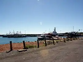
Point Samson, Western Australia
Point Samson is a small coastal settlement 1,579 km north of Perth and 18 km north of Roebourne in the Pilbara region of Western Australia. The town is a popular holiday location for the nearby mining towns, including Wickham, Karratha and Dampier. Fishing is the main industry.
| Point Samson Western Australia | |||||||||
|---|---|---|---|---|---|---|---|---|---|
 Point Samson, Western Australia | |||||||||
 Point Samson | |||||||||
| Coordinates | 20°38′00″S 117°12′00″E | ||||||||
| Population | 231 (2016 census)[1] | ||||||||
| Established | 1880s | ||||||||
| Postcode(s) | 6720 | ||||||||
| Location | 38 km (24 mi) from Karratha | ||||||||
| LGA(s) | City of Karratha | ||||||||
| State electorate(s) | North West | ||||||||
| Federal Division(s) | Durack | ||||||||
| |||||||||
From 1938 to 1966 blue asbestos or crocidolite was carried here by rail from Wittenoom for shiploading by Australian Blue Asbestos Pty. Ltd.[2]
The townsite was investigated for further development in the 1980s.[3]
The population of Point Samson was 231 at the 2016 census,[1] down from 298 in 2011 and 274 in 2006.[4][5]
References
- Australian Bureau of Statistics
- Campbell Environmental Ltd; Western Australia. Dept. of Occupational Health, Safety and Welfare; Western Australia. Dept. of Land Administration; Western Australia. Environmental Protection Authority (1990), Monitoring and cleanup of asbestos at Point Samson for new site development, Campbell Environmental], retrieved 5 May 2012
- Allen, D. J; Western Australia. Dept of Land Administration. Land Planning Development and Management Division (1986), Point Samson townsite proposed development : planning report, Dept. of Land Administration, Land Planning Development and Management Division, retrieved 5 May 2012
- Australian Bureau of Statistics (31 October 2012). "2011 Community Profiles: Point Samson (State Suburb)". 2011 Census of Population and Housing. Retrieved 3 February 2014.

- Australian Bureau of Statistics (25 October 2007). "Community Profile Series : Point Samson (State Suburb)". 2006 Census of Population and Housing. Retrieved 2 October 2008.
This article is issued from Wikipedia. The text is licensed under Creative Commons - Attribution - Sharealike. Additional terms may apply for the media files.