Paveh
Paveh (Persian: Pâveh, Kurdish: Pawe, also Romanized as Pāveh, Pawah, and Pāweh)[2] is a city and capital of Paveh County, Kermanshah Province, Iran. It is located in a region called Hawraman.
Paveh
Pāwe | |
|---|---|
City | |
.jpg.webp) Paveh | |
 Paveh | |
| Coordinates: 35°02′36″N 46°21′23″E | |
| Country | |
| Province | Kermanshah |
| County | Paveh |
| Bakhsh | Central |
| Elevation | 1,560 m (5,120 ft) |
| Population (2016 Census) | |
| • Total | 25,771[1] |
| Time zone | UTC+3:30 (IRST) |
| • Summer (DST) | UTC+4:30 (IRDT) |
| Area code(s) | +(98)83 |
The first language spoken by the population in the city is mostly Kurdish, but the language which is used in schools and offices is Persian, the official language of Iran in which almost everyone in the city is fluent.
History
An old myth regarding the name of the city is that the Emperor Yazdgerd III sent his son named Pav to this area to renew his religious Zoroastrian faith. Both Persians and the local Kurdish inhabitants practiced Zoroastrianism during the Sasanian Empire from which this myth is derived.
Geography
Location, topography
Paveh is located in western Iran and is 112 km far from Kermanshah. It lies in a sub-region along the Iran-Iraq border commonly referred to as Hewraman, which is situated within the larger geographical region of Kurdistan. The city is considered by inhabitants of the region as the capital of Hewraman.
Climate
| Climate data for Paveh | |||||||||||||
|---|---|---|---|---|---|---|---|---|---|---|---|---|---|
| Month | Jan | Feb | Mar | Apr | May | Jun | Jul | Aug | Sep | Oct | Nov | Dec | Year |
| Average high °C (°F) | 4.3 (39.7) |
6.4 (43.5) |
12.2 (54.0) |
16.6 (61.9) |
23.8 (74.8) |
30.5 (86.9) |
35.0 (95.0) |
34.3 (93.7) |
30.2 (86.4) |
23.2 (73.8) |
14.8 (58.6) |
7.4 (45.3) |
19.9 (67.8) |
| Average low °C (°F) | −5.9 (21.4) |
−4.5 (23.9) |
0.4 (32.7) |
4.2 (39.6) |
8.6 (47.5) |
12.2 (54.0) |
16.7 (62.1) |
15.9 (60.6) |
11.0 (51.8) |
6.1 (43.0) |
1.2 (34.2) |
−3.3 (26.1) |
5.2 (41.4) |
| Average precipitation mm (inches) | 120 (4.7) |
111 (4.4) |
124 (4.9) |
97 (3.8) |
45 (1.8) |
0 (0) |
0 (0) |
0 (0) |
0 (0) |
21 (0.8) |
69 (2.7) |
87 (3.4) |
674 (26.5) |
| Source: Climate-Data.org[3] | |||||||||||||
The town is encircled by fruit gardens. Paveh is situated along a mountainside like most cities and villages in the Hewraman region. Behind the city is the Shaho mountain and ahead of the city is a view of Atashgah, another mountain that was once the site of pilgrimages for ancient religions in the region. Among the most visited places is the Quri Qaleh caveman which is considered as the longest watery cave in the Middle East. The cave is located around 25 kilometers from Paveh's city center.
Demographics
At the 2017 census, its population was 25,771, in 7932 families.[4] The inhabitants of Paveh are Kurds and speak Auramani (also:Hewrami). They follow the Shafi‘i branch of Sunni Islam.
Landmarks
Rivers
Sirwan River is one of the biggest rivers in Paveh. It rises near Sanandaj, in the Zagros Mountains of Iran. It then descends through the mountains, where for some 32 km it forms the border between the two countries. It finally feeds into the Tigris below Baghdad. Navigation of the upper reaches of the Diyala is not possible because of its narrow defiles, but the river's valley provides an important trade route between Iran and Iraq.
Mountains
Paveh is established among mountains on Zagros Mountains. The mountain chain of Shaho is located in the west of Paveh. Shaho is the highest mountain in Kermanshah with an elevation of 3390.[5]
Notable people
References
- "Statistical Center of Iran > Home". www.amar.org.ir.
- Paveh can be found at GEOnet Names Server, at this link, by opening the Advanced Search box, entering "-3078102" in the "Unique Feature Id" form, and clicking on "Search Database".
- "Climate: Paveh". Retrieved 2020-04-14.
- "Kermanshah Census". www.amar.org.ir. Statistical Centre of Iran. Retrieved 4 February 2015.
- "Shaho Mountain". mountain-forecast.com. Retrieved 4 February 2015.
External links
![]() Media related to Paveh at Wikimedia Commons
Media related to Paveh at Wikimedia Commons
- Omid Sālehi, Customs of the Land of Stone and Wind (Ā'in-e Sar'zamin-e Sang va Bād), in Persian, Jadid Online, 5 May 2009
- Audio slideshow (5 min 39 sec).
| Capital | 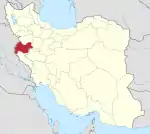 | |
|---|---|---|
| Counties and cities | ||
| Sights |
| |
| populated places | ||
| Capital | |||||||||||||||||||||||||||||
|---|---|---|---|---|---|---|---|---|---|---|---|---|---|---|---|---|---|---|---|---|---|---|---|---|---|---|---|---|---|
| Districts |
| ||||||||||||||||||||||||||||
