Pennsylvania Route 965
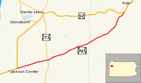
Pennsylvania Route 965 (PA 965) is an 11.6-mile-long (18.7 km) state highway located in Mercer County and Venango County, Pennsylvania. The route terminates at each end at U.S. Route 62 (US 62). In the west, it begins in Jackson Township, before traveling through rural areas to its end in Frenchcreek Township.
| ||||
|---|---|---|---|---|
 | ||||
| Route information | ||||
| Maintained by PennDOT | ||||
| Length | 11.552 mi[1] (18.591 km) | |||
| Major junctions | ||||
| West end | ||||
| East end | ||||
| Location | ||||
| Counties | Mercer, Venango | |||
| Highway system | ||||
| ||||

Route description
PA 965 begins at an intersection with US 62 in the community of Nesbits Corners in Jackson Township, Mercer County, heading east-northeast on two-lane undivided Henderson Road. The road passes through a mix of farms and woods with some homes before passing through open agricultural areas and crossing into Worth Township. The route becomes Jackson Center Polk Road and runs through wooded areas with some fields and residences, crossing PA 173 in Perrine Corners. Past this intersection, PA 965 heads northeast through more rural areas and passes through Henderson.[2][3] PA 965 enters Mineral Township in Venango County and heads through forested areas with some homes, passing through the community of Mount Pleasant. The road continues northeast through more woodland with some farmland and residences. Farther northeast, PA 965 crosses the Sandy Creek into Frenchcreek Township and ends at another intersection with US 62 in Waterloo Bridge.[2][4]
Major intersections
| County | Location | mi[1] | km | Destinations | Notes |
|---|---|---|---|---|---|
| Mercer | Jackson Township | 0.000 | 0.000 | Western terminus | |
| Worth Township | 2.945 | 4.740 | |||
| Venango | Frenchcreek Township | 11.552 | 18.591 | Eastern terminus | |
| 1.000 mi = 1.609 km; 1.000 km = 0.621 mi | |||||
See also
 U.S. Roads portal
 Pennsylvania portal
References
- "Pennsylvania state roads". Pennsylvania Spatial Data Access. Pennsylvania Department of Transportation. 2013. Retrieved March 14, 2013.
- Google (August 13, 2011). "overview of Pennsylvania Route 965" (Map). Google Maps. Google. Retrieved August 13, 2011.
- Mercer County, Pennsylvania Highway Map (PDF) (Map). PennDOT. 2011. Retrieved May 19, 2011.
- Venango County, Pennsylvania Highway Map (PDF) (Map). PennDOT. 2011. Archived from the original (PDF) on September 6, 2011. Retrieved May 23, 2011.