Pennsylvania Route 351
Pennsylvania Route 351 (PA 351) is a 17.2-mile-long (27.7 km) state highway located in Lawrence and Beaver counties in Pennsylvania. The western terminus is at the Ohio border in Little Beaver Township (just south of S.N.P.J). The eastern terminus is at PA 65/PA 288 in Ellwood City.
| |||||||
|---|---|---|---|---|---|---|---|
 | |||||||
| Route information | |||||||
| Maintained by PennDOT | |||||||
| Length | 17.227 mi[1] (27.724 km) | ||||||
| Major junctions | |||||||
| West end | |||||||
| |||||||
| East end | |||||||
| Location | |||||||
| Counties | Lawrence, Beaver | ||||||
| Highway system | |||||||
| |||||||

Route description
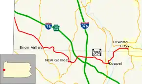
PA 351 begins at the Ohio border in Little Beaver Township, Lawrence County, where the road continues into Ohio as SR 617. From the state line, the route heads southeast on a two-lane undivided road, heading through open agricultural areas with some woods and homes. The road turns to the east-southeast and continues through more rural areas, crossing the North Fork Little Beaver Creek and reaching an intersection with PA 551. At this point, PA 351 forms a concurrency with PA 551, heading through more areas of farms, woods, and residences as it passes through Old Enon. The road heads into the borough of Enon Valley and becomes State Street, heading into residential areas and merging onto Main Street. PA 351 splits from PA 551 by turning east onto Vine Street, heading into agricultural areas and crossing back into Little Beaver Township, where it becomes an unnamed road. The road passes over Norfolk Southern's Fort Wayne Line and turns to the south, heading into wooded areas with some homes.[2][3]
PA 351 enters Darlington Township in Beaver County and becomes Crescent Drive, turning southeast into a mix of farmland and woodland with some homes. The route crosses the North Fork Little Beaver Creek again and heads into more wooded areas, crossing into the borough of Big Beaver. The road turns south near more fields and heads into the borough of New Galilee, becoming Cleveland Drive and curving southwest past homes. PA 351 turns northeast onto Cleveland Street Extended before turning east onto Monroe Street, crossing Norfolk Southern's Fort Wayne Line. The route passes more homes before intersecting PA 168 and turning south to join that route on Centennial Avenue. PA 351 splits from PA 168 by turning east onto Fairlane Boulevard, crossing back into Big Beaver. The road turns to the northeast through woodland, coming to a bridge over the Pennsylvania Turnpike (Interstate 76, I-76). From here, the route turns northeast through a mix of farms and woods with some homes, crossing over I-376. A short distance later, PA 351 comes to an intersection with Shenango Road, which provides access to both I-76 and I-376. Past this, the road passes a few fields and homes before continuing southeast through more forested areas. The route turns east through wooded areas of homes before coming to a junction with PA 18. At this intersection, PA 351 crosses into the borough of Koppel and becomes Arthur Street, passing residences and businesses. The route crosses Norfolk Southern's Koppel Secondary railroad line and turns north onto 5th Avenue, heading past more development. The road curves northeast and passes near industry, crossing under a CSX railroad line before becoming unnamed and heading northeast through woodland. PA 351 comes to the Koppel Bridge that crosses over CSX's Pittsburgh Subdivision rail line before passing over the Beaver River into North Sewickley Township and heading over Norfolk Southern's Youngstown Line and another CSX railroad line. Past the bridge, the route turns north onto River Road and heads through wooded areas with some commercial development.[2][4]
PA 351 heads into Wayne Township in Lawrence County and becomes West Lawrence Avenue, turning northeast and running through the residential community of Park Gate. The road heads into the borough of Ellwood City and turns to the east, becoming Lawrence Avenue and passing through business areas. Farther east, the route heads through the commercial downtown before turning south onto 4th Street. A block later, PA 351 turns east onto Crescent Avenue and passes homes before ending at PA 65/PA 288.[2][3]
History
| |
|---|---|
| Location | New Galilee-Koppel |
| Length | 4.0 mi (6.4 km) |
| Existed | 1928–May 1937[5] |
PA 351 was signed in 1926, running from the Ohio state line to PA 451 New Galilee. In 1936, PA 451 was decommissioned, allowing PA 351 to extend its eastern segment to PA 18 in Koppel. Later that same year, PA 351 was extended one last time to its current eastern terminus at PA 65/PA 288 in Ellwood City.
Major intersections
| County | Location | mi[1] | km | Destinations | Notes |
|---|---|---|---|---|---|
| Lawrence | Little Beaver Township | 0.000 | 0.000 | Western terminus of PA 351 at Ohio state line | |
| 4.051 | 6.519 | Western terminus of PA 551 concurrency | |||
| Enon Valley | 5.488 | 8.832 | Eastern terminus of PA 551 concurrency | ||
| Beaver | New Galilee | 9.132 | 14.697 | Western terminus of PA 168 concurrency | |
| 9.307 | 14.978 | Eastern terminus of PA 168 concurrency | |||
| Big Beaver | 11.495 | 18.499 | |||
| Koppel | 13.674 | 22.006 | |||
| Lawrence | Ellwood City | 17.227 | 27.724 | Eastern terminus of PA 351 | |
1.000 mi = 1.609 km; 1.000 km = 0.621 mi
| |||||
PA 351 Truck
Koppel
| |
|---|---|
| Location | Koppel, Pennsylvania |
| Length | 16.4 mi[6] (26.4 km) |
| Existed | 2013–present |
Pennsylvania Route 351 Truck is a truck route that bypasses the weight-restricted Koppel Bridge that carries the route over the Beaver River and CSX and Norfolk Southern railroad lines in Koppel, on which trucks over 31 tons are prohibited. The route follows PA 18, PA 588, PA 65, and PA 65/288. PA 351 Truck was signed in 2013.[6][7]
Ellwood City
| |
|---|---|
| Location | Ellwood City, Pennsylvania |
| Length | 0.80 mi[8] (1.3 km) |
| Existed | 2013–present |
Pennsylvania Route 351 Truck is a truck route that bypasses a portion of PA 351 in Ellwood City. The truck route follows the one-way pair of 5th Street north in the eastbound direction and Spring Avenue west and 6th Street south in the westbound direction before both directions head north along 5th Street and then east and south along PA 65/PA 288. The route was signed in 2013.[8]
See also
 U.S. Roads portal
 Pennsylvania portal
- Raymond Robinson (Green Man)
References
- Bureau of Maintenance and Operations (January 2019). Roadway Management System Straight Line Diagrams (Report) (2019 ed.). Pennsylvania Department of Transportation. Retrieved March 1, 2019.
- Lawrence County (PDF)
- Beaver County (PDF)
- Google (August 5, 2011). "overview of Pennsylvania Route 351" (Map). Google Maps. Google. Retrieved August 5, 2011.
- Lawrence County, Pennsylvania Highway Map (PDF) (Map). PennDOT. 2011. Archived from the original (PDF) on August 5, 2011. Retrieved May 21, 2011.
- Beaver County, Pennsylvania Highway Map (PDF) (Map). PennDOT. 2011. Archived from the original (PDF) on August 5, 2011. Retrieved May 14, 2011.
- "Route Numbers Change on Roads". New Castle News. New Castle, Pennsylvania. May 4, 1937. p. 18. Retrieved May 12, 2016 – via Newspapers.com.

- Google (April 14, 2016). "overview of Pennsylvania Route 351 Truck Koppel" (Map). Google Maps. Google. Retrieved April 14, 2016.
- "Risk-Based Bridge Postings - State and Local Bridges" (PDF). Pennsylvania Department of Transportation. October 8, 2013. Retrieved January 20, 2016.
- Google (April 14, 2016). "overview of Pennsylvania Route 351 Truck Ellwood City" (Map). Google Maps. Google. Retrieved April 14, 2016.
External links
| Wikimedia Commons has media related to Pennsylvania Route 351. |