Beaver Falls, Pennsylvania
Beaver Falls is a city in Beaver County, Pennsylvania, United States. The population was 8,987 at the 2010 census. It is located 31 miles (50 km) northwest of Pittsburgh, and on the Beaver River, six miles (9 km) north of its confluence with the Ohio River.
Beaver Falls, Pennsylvania | |
|---|---|
| City of Beaver Falls | |
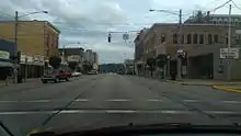
.JPG.webp) View of Beaver Falls, from the borough of New Brighton. | |
| Nicknames: Birthplace of College Basketball | |
 Location in Beaver County and the U.S. state of Pennsylvania. | |
| Coordinates: 40°45′32″N 80°19′11″W | |
| Country | United States |
| State | Pennsylvania |
| County | Beaver County |
| Incorporated | November 9, 1868 (borough) |
| Government | |
| • Mayor | George Quay (interim) |
| Area | |
| • Total | 2.35 sq mi (6.09 km2) |
| • Land | 2.13 sq mi (5.51 km2) |
| • Water | 0.22 sq mi (0.58 km2) |
| Population (2010) | |
| • Total | 8,987 |
| • Estimate (2019)[2] | 8,332 |
| • Density | 3,915.41/sq mi (1,511.77/km2) |
| Time zone | UTC−5 (EST) |
| • Summer (DST) | UTC−4 (EDT) |
| ZIP Code | 15010 |
| FIPS code | 42-04792 |
| Website | City website |
History
| Historical population | |||
|---|---|---|---|
| Census | Pop. | %± | |
| 1870 | 3,112 | — | |
| 1880 | 5,104 | 64.0% | |
| 1890 | 9,735 | 90.7% | |
| 1900 | 10,054 | 3.3% | |
| 1910 | 12,191 | 21.3% | |
| 1920 | 12,802 | 5.0% | |
| 1930 | 17,147 | 33.9% | |
| 1940 | 17,098 | −0.3% | |
| 1950 | 17,375 | 1.6% | |
| 1960 | 16,240 | −6.5% | |
| 1970 | 14,635 | −9.9% | |
| 1980 | 12,525 | −14.4% | |
| 1990 | 10,687 | −14.7% | |
| 2000 | 9,920 | −7.2% | |
| 2010 | 8,987 | −9.4% | |
| 2019 (est.) | 8,332 | [2] | −7.3% |
| U.S. Decennial Census[3] | |||
In the 1870s, Beaver Falls was home to a Chinatown and had up to 225 Chinese residents, brought in to work at Beaver Falls Cutlery Company.[4][5]
On May 31, 1985, an F3 tornado hit just north of the city as it went across northern portions of Beaver County, as part of the 1985 United States-Canadian tornado outbreak.[6]
The population declined nearly 50% between 1940 and 2000, which is attributed mostly to its central location in the Rust Belt.[7][8][9]
Geography
Beaver Falls is located at 40°45′32″N 80°19′11″W (40.758865, -80.319737).[10]
Demographics
.jpg.webp)
As of the census[11] of 2000, there were 9,920 people, 3,798 households, and 2,259 families residing in the city. The population density was 4,681.6 people per square mile (1,806.7/km2). There were 4,380 housing units at an average density of 2,067.1 per square mile (797.7/km2). The racial makeup of the city was 78.82% White, 17.53% African American, 0.13% Native American, 0.62% Asian, 0.02% Pacific Islander, 0.50% from other races, and 2.37% from two or more races. Hispanic or Latino of any race were 1.06% of the population.
Notable people
- Joe Namath, Hall of Fame AFL and NFL quarterback[12]
Neighborhoods
Sites of interest
Transportation
Air
The closest airport to the city is Beaver County Airport. Though located in Allegheny County, Pittsburgh International Airport is within close proximity of Beaver Falls, and is easily accessible by way of I-376 (former PA 60).[13]
References
- "2019 U.S. Gazetteer Files". United States Census Bureau. Retrieved July 28, 2020.
- "Population and Housing Unit Estimates". United States Census Bureau. May 24, 2020. Retrieved May 27, 2020.
- "Census of Population and Housing". Census.gov. Retrieved June 4, 2015.
- "Chinese Workers In Beaver Falls". Archived from the original on 2011-06-09.
- Anon (1993). "Gone but not forgotten: the Beaver Falls Cutlery Company". Industrious Beaver Falls. Darlington, Pennsylvania: Beaver County Industrial Museum. This is based on Anon (1992). "The history and lore of Beaver Co.: the Chinese in Beaver Falls 1872". The Beaver Countian Vol III no.1. Beaver Falls, Pennsylvania. pp. 1–3.
- Britten, Kenneth, Beaver Falls Gem of Beaver County, Arcadia Publishing, 2002, ISBN 0-7385-2382-8.
- "Archived copy". Archived from the original on 2010-03-27. Retrieved 2017-12-07.CS1 maint: archived copy as title (link)
- "Archived copy". Archived from the original on 2010-05-05. Retrieved 2017-12-07.CS1 maint: archived copy as title (link)
- https://www.census.gov/prod/cen1990/cph2/cph-2-1-1.pdf
- "US Gazetteer files: 2010, 2000, and 1990". United States Census Bureau. 2011-02-12. Retrieved 2011-04-23.
- "U.S. Census website". United States Census Bureau. Retrieved 2008-01-31.
- Wilson, Earl (Nov 27, 1969). "Small Towns Have Produced Many Big Stars". The Milwaukee Sentinel. pp. A33. Retrieved 22 May 2015.
- Highway now I-376 from Monroeville to Mercer
External links
| Wikimedia Commons has media related to Beaver Falls, Pennsylvania. |
| Wikivoyage has a travel guide for Beaver Falls. |
- City website
 Texts on Wikisource:
- "Beaver Falls". New International Encyclopedia. 1905.
- "Beaver Falls". Collier's New Encyclopedia. 1921.
- "Beaver Falls, Pa.". The New Student's Reference Work. 1914.

| Counties |  Map of the Pittsburgh Tri-State with green counties in the metropolitan area and yellow counties in the combined area | |
|---|---|---|
| Major cities | ||
| Cities and towns 15k–50k (in 2010) | ||
| Airports | ||
| Topics | ||
| ||
Municipalities and communities of Beaver County, Pennsylvania, United States | ||
|---|---|---|
| Cities | 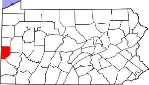 | |
| Boroughs |
| |
| Townships | ||
| Census-designated places | ||
| Other unincorporated communities | ||
| Footnotes | ‡This populated place also has portions in an adjacent county or counties. | |
| ||
| Authority control |
|---|