Pennsylvania Route 405
Pennsylvania Route 405 (PA 405) is a 27.963-mile-long (45.002 km) state highway that runs in the north-central part of the U.S. state of Pennsylvania. The southern terminus of PA 147 in West Chillisquaque Township near the borough of Milton. The route heads northward along the West Branch Susquehanna River through Milton, Watsontown and Muncy until entering Hughesville, where it terminates at an intersection with U.S. Route 220 (US 220).
| ||||
|---|---|---|---|---|
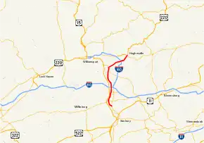 Major highways in the Williamsport area with PA 405 in red | ||||
| Route information | ||||
| Maintained by PennDOT | ||||
| Length | 27.963 mi[1] (45.002 km) | |||
| Existed | 1941[2]–present | |||
| Major junctions | ||||
| South end | ||||
| North end | ||||
| Location | ||||
| Counties | Lycoming, Northumberland | |||
| Highway system | ||||
| ||||

PA 405 originated as the Muncy and Hughesville Plank Road, a 5-mile (8.0 km) plank road from Muncy to Hughesville, created in 1853. The plank road also consisted of a bridge over the Muncy Canal on the outskirts of the community. PA 405 was assigned in 1941, after switching between numerous designations, including alignments of US 15, US 111, US 220, and US 711. The alignment of PA 405 was extended to its current southern terminus when PA 147 was realigned onto a new highway. As part of the Central Susquehanna Valley Thruway project, PA 405 will continue south from its current southern terminus, replacing the stretch of PA 147 until its junction with PA 61 in Sunbury, its new southern terminus. PA 147 will have a new alignment between those two junctions and will not be duplexed with PA 405 at any point.
Route description
PA 147 to Watsontown
.JPG.webp)
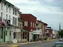
PA 405 begins at an intersection with PA 147 in Chillisquaque. The route heads to the northwest, heading along a parallel to PA 147 near rural farms and houses. The route reaches the center of Chillisquaque, where it turns westward for a distance through an isolated area along the West Branch of the Susquehanna River. The route meets the shoreline, where PA 405 turns to the northwest along a rural, unpopulated stretch of West Chillisquaque Township. The route heads northward, crossing through a deep patch of forests. A short distance later, the forests dissipate, and PA 405 intersects with PA 45 (the Purple Heart Highway) just across the river from the borough of Lewisburg. PA 405 continues northward along the Susquehanna River, intersecting with a former alignment of PA 45 a short distance later. The route continues through the rural farmland along the river, entering the small community of East Lewisburg. North of East Lewisburg, PA 405 passes a large farmland plot before leaving the shoreline of the Susquehanna West Branch. The route continues northward a short distance from the Susquehanna River before entering the borough of Milton.[3]
In Milton, PA 405 crosses over a set of railroad tracks and turns onto Ferry Lane. The route heads eastward until turning northward onto Garfield Street, heading past homes and businesses and intersecting with PA 642 (Mahoning Street). The route continues northward onto South Arch Street, intersecting with Center Street, where it turns northward. At the end of the block, PA 405 intersects with PA 254 (Broadway). The highway continues northward, intersecting with local streets and paralleling railroad tracks. At the intersection with 10th Street, PA 405 turns to the northwest and leaves the community of Milton. The route returns to the shoreline of the West Branch of the Susquehanna River, continuing northward along the Turbot Hills Golf Course. The route continues northward, intersecting with Golf Course Road, where the route becomes surrounded by forests. A short distance later, PA 405 crosses under the four lane alignment of Interstate 80 (I-80) and intersects an old alignment of the Susquehanna Trail. The route continues northward along the West Branch of the Susquehanna River, passing a large industrial complex before reaching a merge in the railroad tracks. At the merge, PA 405 enters the borough of Watsontown.[3]
Watsontown to Hughesville
After entering Watsontown, PA 405 passes the local memorial park and intersects with PA 44 (South Main Street). PA 405 and PA 44 become concurrent along Main Street into downtown Watsontown. The two highways continue several blocks from the Susquehanna River, intersecting with Brimmer Avenue. The surroundings of the highways are highly populated, and the two routes continue in Watsontown until an intersection with East 11th Street, when the two roads leave the community. PA 405 and PA 44 continue northward, intersecting with local roads in a rural region north of Watsontown. The highways continue, entering the community of Dewart, where PA 44 turns to the west towards the Susquehanna West Branch. PA 405 continues northward, bypassing around Dewart and crossing the railroad tracks it had been paralleling for the distance. The route continues northward, leaving Dewart at an intersection with Delaware Drive. The route heads northward, crossing through the rural areas before intersecting with PA 54, where they merge. PA 405 and PA 54 continue through a deep patch of forests before crossing the river, entering the borough of Montgomery.[3]
In Montgomery, PA 405 and PA 54 continue for a short distance along Second Street, until Montgomery Street, where PA 405 turns to the northeast, while PA 54 turns to the northwest. PA 405 continues along Montgomery Street, passing through downtown. At an intersection with School House Road, the highway leaves Montgomery. PA 405 continues to the northeast along a set of railroad tracks and at an intersection with Saegers Station Road, enters the community of Saegers. At a merge with Private 158 Road, PA 405 turns to the north, passing the small community to the north. At an intersection with Armstrong Road, the highway turns to the northeast, leaving Saegers. The route continues to the east, crossing over the West Branch once again, entering the borough of Muncy. In Muncy, the highway heads to the southeast along Water Street into the community center, where it turns to the northeast. The route leaves Muncy a short distance later, interchanging with I-180 Exit 13. PA 405 passes south of a park and ride lot and heads to the northeast until reaching Muncy Creek, where it turns to the southeast, intersecting with the western terminus of PA 442. PA 405 continues farther, intersecting with local roads, running along South Main Street for a distance, entering the borough of Hughesville, where the highway becomes densely populated. The route heads northward, intersecting with the western terminus of PA 118. The route continues northward for a short distance, with the Route 405 designation terminating at an intersection with US 220.[3]
History

Old roads
The short alignment of PA 405 from Muncy to Hughesville contains the most of the highway's history. The bridge over the West Branch of the Susquehanna River was originally privately maintained, with the charter for its construction coming down from the Pennsylvania State Legislature on March 13, 1835.[4] The charter designated the company that owned the bridge as the Susquehanna Bridge Company at Walton's Landing (now Muncy) and the state appointed eleven commissioners to help erect the toll bridge.[5] In 1853, a portion of land from the Susquehanna River West Branch (which was a canal at the time) was chartered to become a canal. The canal was constructed in 1848 by a privately maintained company for $3,000 (1848 USD). The bridge over the canal that currently uses PA 405 was constructed in 1854 at a cost of $27,000 (1854 USD), nine times the amount to construct the canal. The portion of PA 405 from Muncy to Hughesville was also chartered in 1853, consisting of a plank road between the two towns.[6]
Designation
On May 31, 1911, the state of Pennsylvania signed the Sproul Road Bill, which started a drastic state takeover of highways. Originally, only several routes were assigned around the state. The stretch of PA 405 from the southern terminus to the current day intersection with PA 44 was designated as Legislative Route 18. The portion of PA 405 along the PA 44 concurrency to Delwart was designated as Legislative Route 240 (most of this alignment is PA 44). The stretch from Delwart to Montgomery was not designated in 1911. From Montgomery to Muncy, PA 405 follows more of Legislative Route 240. After Muncy, PA 405 follows Legislative Route 19 until the current terminus in Hughesville.[7]
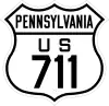
When the switch was made in 1924 from the old highway system in Pennsylvania, the alignment of PA 405 was designated as PA 4 from the community of Chillisquaque to the intersection with the Susquehanna Trail. PA 4 was designated in 1925 along the main alignment of the Susquehanna Trail.[8][9] The route designation remained in place for a short time. The stretch from Muncy to Hughesville (which followed the alignment of the Penn's Plank Road), was designated in 1926 as an alignment of US 220.[10] The portion of PA 4 from Chillisquaque to the Susquehanna trail was also designated as US 111 and US 711, both decommissioned spurs of US 11 in 1926. US 111 remained in place until 1936, while US 711 and PA 4 were decommissioned in 1928[11] and 1930 respectively.[12] In 1928, the segment of PA 4 from Watsontown to Muncy was re-designated as PA 14.[11] In 1936, US 111 was decommissioned, and the route from Chillisquaque to Watsontown was redesignated as part of US 15.[13] PA 14, US 220 and US 15 remained on most of PA 405's alignment until 1941, when the alignment of all three routes were changed.[14] Upon the decommissioning, PA 405 was designated onto the alignment from the Susquehanna Trail (where it intersected with PA 147) to Hughesville.[2] The alignment of PA 405 south of the Susquehanna Trail was part of PA 147[15] until 1972, when it was realigned, and PA 405 was extended to Chillisquaque.[16]
Proposed extension
PA 405 currently has its southern terminus at PA 147 in the community of Chillisquaque. Near that intersection, PA 147 turns into a super-2 freeway towards Williamsport. The Central Susquehanna Valley Thruway project is proposing to extend the super-two freeway alignment of PA 147 on a new freeway along the opposite side of the Susquehanna. The designation of PA 405 is proposed to be extended over the non-freeway alignment of PA 147 down to an intersection with PA 61 in Sunbury. An interchange with PA 405 would also be constructed.[17] The 12 mi (19 km) long project will also involve a realignment of US 11/US 15 onto the new alignment as well, a proposal that lost funding in the 1970s.[18] As of July 2009, the design is 40% completed, while the project was put on a freeze by Governor Edward Rendell. The project, which will take $9 million (2009 USD) to study and design, and another $525 million (2009 USD) to construct.[19]
Major intersections
| County | Location | mi[1] | km | Destinations | Notes |
|---|---|---|---|---|---|
| Northumberland | West Chillisquaque Township | 0.000 | 0.000 | Interchange, southern terminus | |
| 2.746 | 4.419 | ||||
| Milton | 6.428 | 10.345 | |||
| 6.775 | 10.903 | Western terminus of PA 254 | |||
| Watsontown | 10.998 | 17.700 | Southern terminus of concurrency | ||
| Delaware Township | 13.276 | 21.366 | Northern terminus of concurrency | ||
| 16.733 | 26.929 | Southern terminus of concurrency | |||
| Lycoming | Montgomery | 17.820 | 28.679 | Northern terminus of concurrency | |
| Muncy | 24.086– 24.106 | 38.763– 38.795 | Exit 13 (I-180) | ||
| Muncy Creek Township | 24.790 | 39.896 | Western terminus of PA 442 | ||
| Hughesville | 27.610 | 44.434 | Western terminus of PA 118 | ||
| 27.963 | 45.002 | Northern terminus | |||
1.000 mi = 1.609 km; 1.000 km = 0.621 mi
| |||||
See also
 U.S. Roads portal
 Pennsylvania portal
- West Branch of the Susquehanna River
References
- Bureau of Maintenance and Operations (January 2015). Roadway Management System Straight Line Diagrams (Report) (2015 ed.). Pennsylvania Department of Transportation. Retrieved June 30, 2015.
- Northumberland County (PDF)
- Lycoming County (PDF)
- "New 1941 Official Highway Map Ready for Distribution". Elizabethville Echo. June 26, 1941. p. 3. Retrieved November 13, 2017 – via Newspapers.com.

- Microsoft; Nokia (July 15, 2015). "Overview map of Pennsylvania Route 405" (Map). Bing Maps. Microsoft. Retrieved July 15, 2015.
- Beitel, Calvin Gustavus (1874). A digest of titles of corporations chartered by the legislature of Pennsylvania, between the years 1700 and 1873 inclusive: giving the dates of acts of incorporation, with the several supplements thereto, with a reference to the pages of the pamphlet laws, where they may be found (2 ed.). J. Cambbell & Son. p. 151. Retrieved August 6, 2009.
- "An act to incorporate a company to erect a toll bridge over the West Branch of the river Susquehanna at Walton's landing". Pennsylvania State Legislature. March 13, 1835. Retrieved August 6, 2009.
- Meginness, John Franklin (1857). Otzinachson. John Meginness. p. 423. Retrieved August 6, 2009.
Muncy and Hughesville Plank Road.
- Map of State Roads (PDF) (Map). Pennsylvania Department of Highways. 1911. Retrieved July 24, 2009.
- "U.S. Route 22 - The William Penn Highway". United States Department of Transportation. 2009. Retrieved July 24, 2009.
- Map Showing Pennsylvania State Highway Routes (Map). Cartography by Pennsylvania Department of Highways. Pennsylvania Department of Highways. 1925.
- Bureau of Public Roads & American Association of State Highway Officials (November 11, 1926). United States System of Highways Adopted for Uniform Marking by the American Association of State Highway Officials (Map). 1:7,000,000. Washington, DC: U.S. Geological Survey. OCLC 32889555. Retrieved November 7, 2013 – via University of North Texas Libraries.
- Map Showing Pennsylvania State Highways (Map). Pennsylvania Department of Highways. 1928.
- Tourist Map of Pennsylvania State Highways (Map). Cartography by Pennsylvania Department of Highways. Pennsylvania Department of Highways. 1930.
- Official Pennsylvania Road Map (Map). Cartography by Pennsylvania Department of Highways. Pennsylvania Department of Highways. 1937.
- Pennsylvania Official Road Map (Map). Pennsylvania Department of Highways. 1941.
- Pennsylvania (Map). Pennsylvania Department of Highways. 1963.
- Pennsylvania (Map). Pennsylvania Department of Highways. 1972.
- "Proposed Roadway Route Designations" (PDF). Central Susquehanna Valley Transportation Project. 2009. Archived from the original (PDF) on July 8, 2011. Retrieved August 6, 2009.
- Carney, Christopher P. (July 17, 2007). "Oberstar: I Am Very Optimsitc About This Project". Office of Christopher P. Carney, 10th Legislative District. Archived from the original on August 5, 2009. Retrieved August 6, 2009.
- Morton, Gina (July 17, 2009). "Thruway makes progress (on paper)". The Daily Item. Archived from the original on January 20, 2013. Retrieved August 6, 2009.
External links
 Media related to Pennsylvania Route 405 at Wikimedia Commons
- Kitsko, Jeffrey J. (2009). "PA 405". Pennsylvania Highways. Retrieved August 6, 2009.
