Northumberland County, Pennsylvania
Northumberland County is a county located in the U.S. state of Pennsylvania. As of the 2010 census, the population was 94,528.[1] Its county seat is Sunbury.[2] The county was formed in 1772 from parts of Lancaster, Berks, Bedford, Cumberland, and Northampton Counties and named for the county of Northumberland in northern England. Northumberland County is a fifth class county according to the Pennsylvania's County Code.[3]
Northumberland County | |
|---|---|
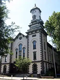 Northumberland County Courthouse | |
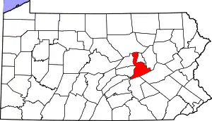 Location within the U.S. state of Pennsylvania | |
 Pennsylvania's location within the U.S. | |
| Coordinates: 40°51′N 76°43′W | |
| Country | |
| State | |
| Founded | March 21, 1772 |
| Named for | Northumberland |
| Seat | Sunbury |
| Largest city | Sunbury |
| Area | |
| • Total | 478 sq mi (1,240 km2) |
| • Land | 458 sq mi (1,190 km2) |
| • Water | 19 sq mi (50 km2) 4.0%% |
| Population | |
| • Estimate (2018) | 91,083 |
| • Density | 204/sq mi (79/km2) |
| Time zone | UTC−5 (Eastern) |
| • Summer (DST) | UTC−4 (EDT) |
| Congressional districts | 9th, 12th |
| Website | www |
Northumberland County comprises the Sunbury, PA Micropolitan Statistical Area, which is also included in the Bloomsburg-Berwick-Sunbury, PA Combined Statistical Area.
Among its famous residents, Joseph Priestley, the Enlightenment chemist and theologian, left England in 1796 due to religious persecution and settled on the Susquehanna River. His former house (originally purchased by chemists from Pennsylvania State University after a colloquium that founded the American Chemical Society[4]) is a historical museum.[5]
History
Before European settlement the area was inhabited by the Akhrakouaeronon or Atrakouaehronon, a subtribe of the Susquehannock. By 1813 the area once comprising the sprawling county of Northumberland had been divided over time and allotted to other counties such that lands once occupied by Old Northumberland at its greatest extent are now found in Centre, Columbia, Luzerne, Lycoming, Mifflin, Union, Clearfield, Clinton, Montour, Bradford, Lackawanna, Susquehanna, Wyoming, Tioga, Potter, McKean, Warren, Venango, Snyder, and Schuylkill Counties.
Geography

.JPG.webp)
According to the U.S. Census Bureau, the county has a total area of 478 square miles (1,240 km2), of which 458 square miles (1,190 km2) is land and 19 square miles (49 km2) (4.0%) is water.[6]
The county has a humid continental climate (Dfa/Dfb). Average temperatures in Sunbury range from 27.3 °F in January to 72.7 °F in July, while in Mount Carmel they range from 25.0 °F in January to 70.2 °F in July.
The main river in Northumberland County is the Susquehanna River and the divergence of the 977 miles (1,572 km) long river into its two branches of navigable river and former divisions of the Pennsylvania Canal System. The Susquehanna River's tributaries in the county include the West Branch Susquehanna River, Chillisquaque Creek, Shamokin Creek, and the west flowing Mahanoy Creek, whose valley is a rail and road transportation corridor to Tamaqua and points thereafter either east, north, or south such that: east along rail or US 209 through Nesquehoning and historic Jim Thorpe; else northeast via Beaver Meadows leading north into Hazelton and the lower Wyoming Valley, or into the central Wyoming Valley skirting along the western Poconos via White Haven and Mountain Top; or otherwise head south through the Schuylkill Gap into Port Carbon and thence west to the Lancaster County or east via the greater Reading area into the lower Schuylkill Valley and Philadelphia. The county has mountains in the south and north, with the rest being mostly rolling hills.
Mountains
| Name | Height |
| Mahanoy Mountain | 433 meters |
| Big Mountain | 402 meters |
Major highways
Adjacent counties
- Lycoming County (north)
- Montour County (northeast)
- Columbia County (east)
- Schuylkill County (southeast)
- Dauphin County (south)
- Perry County (southwest)
- Juniata County (west)
- Snyder County (west)
- Union County (west)
Demographics
| Historical population | |||
|---|---|---|---|
| Census | Pop. | %± | |
| 1790 | 17,147 | — | |
| 1800 | 27,797 | 62.1% | |
| 1810 | 36,327 | 30.7% | |
| 1820 | 15,424 | −57.5% | |
| 1830 | 18,133 | 17.6% | |
| 1840 | 20,027 | 10.4% | |
| 1850 | 23,272 | 16.2% | |
| 1860 | 28,922 | 24.3% | |
| 1870 | 41,444 | 43.3% | |
| 1880 | 53,123 | 28.2% | |
| 1890 | 74,698 | 40.6% | |
| 1900 | 90,911 | 21.7% | |
| 1910 | 111,420 | 22.6% | |
| 1920 | 122,079 | 9.6% | |
| 1930 | 128,504 | 5.3% | |
| 1940 | 126,887 | −1.3% | |
| 1950 | 117,115 | −7.7% | |
| 1960 | 104,138 | −11.1% | |
| 1970 | 99,190 | −4.8% | |
| 1980 | 100,381 | 1.2% | |
| 1990 | 96,771 | −3.6% | |
| 2000 | 94,556 | −2.3% | |
| 2010 | 94,528 | 0.0% | |
| 2018 (est.) | 91,083 | [7] | −3.6% |
| U.S. Decennial Census[8] 1790–1960[9] 1900–1990[10] 1990–2000[11] 2010–2017[1] | |||
As of the census[12] of 2000, there were 94,556 people, 38,835 households, and 25,592 families residing in the county. The population density was 206 people per square mile (79/km2). There were 43,164 housing units at an average density of 94 per square mile (36/km2). The racial makeup of the county was 97.09% White, 1.52% Black or African American, 0.10% Native American, 0.22% Asian, 0.02% Pacific Islander, 0.47% from other races, and 0.58% from two or more races. 1.10% of the population were Hispanic or Latino of any race. 32.5% were of German, 12.9% Polish, 9.9% American, 8.2% Italian, 8.1% Irish and 5.8% Dutch ancestry. 95.8% spoke English and 1.5% Spanish as their first language.
There were 38,835 households, out of which 27.30% had children under the age of 18 living with them, 52.40% were married couples living together, 9.60% had a female householder with no husband present, and 34.10% were non-families. 30.20% of all households were made up of individuals, and 15.50% had someone living alone who was 65 years of age or older. The average household size was 2.34 and the average family size was 2.89.
In the county, the population was spread out, with 21.90% under the age of 18, 7.00% from 18 to 24, 27.70% from 25 to 44, 24.40% from 45 to 64, and 19.00% who were 65 years of age or older. The median age was 41 years. For every 100 females there were 96.30 males. For every 100 females age 18 and over, there were 92.80 males.
Northumberland County's live birth rate was 1,167 births in 1990. Northumberland County's live birth rate in 2000 declined to 919 births, while in 2011 it was 961 babies.[13] Over the past 50 years (1960 to 2010), rural Pennsylvania saw a steady decline in both the number and proportion of residents under 18 years old. In 1960, 1.06 million rural residents, or 35 percent of the rural population, were children.
- County poverty demographics
According to research by The Center for Rural Pennsylvania, which is a legislative agency of the Pennsylvania General Assembly, the poverty rate for Northumberland County was 15.9% in 2014.[14] The statewide poverty rate was 13.6% in 2014. The 2012 childhood poverty rate by school district was: Line Mountain School District - 38.4% living at 185% or below than the Federal Poverty Level, Milton Area School District - 51.9, Mount Carmel Area School District - 59.5%, Shikellamy School District - 45%, Shamokin Area School District - 59.5% and Warrior Run School District - 32.2%.[15]
According to the US Census Bureau, from 2009 to 2014 Northumberland County saw a 62% increase in the number of families in the federal food assistance program called SNAP (Supplemental Nutrition Assistance Program).[16] The number of people or families receiving monthly SNAP (food stamps) assistance dollars rose from 2,965 in 2009 to 4,814 people in 2014.[17]
- Teen Pregnancy rate
The Pennsylvania Department of Health reports the annual teens aged 15–19 birth rate. From 2011 to 2015, Northumberland County experienced a 10% decline in teen pregnancies.[18] In Pennsylvania the majority of pupils graduate from high school at age 18 years old. Northumberland County is home to an Amish population, where pregnancies at 17–19 years old are common.[19]
- 2015 - 643
- 2014 - 664
- 2013 - 689
- 2012 - 709
- 2011 - 715
In 2016, more than 200 children in Northumberland County were in foster care. The majority of the children are from the eastern side of the county in Shamokin and Mount Carmel. They are placed in foster care largely due to drug and alcohol abuse by parents/caregivers.[20]
Micropolitan Statistical Area
The United States Office of Management and Budget[21] has designated Northumberland County as the Sunbury, PA Micropolitan Statistical Area (µSA). As of the 2010 census[22] the micropolitan area ranked 2nd most populous in the State of Pennsylvania and the 37th most populous in the United States with a population of 94,528. Northumberland County is also a part of the Bloomsburg–Berwick–Sunbury, PA Combined Statistical Area (CSA), which combines the population of Northumberland County as well as the Columbia, Montour, Snyder and Union County areas. The Combined Statistical Area ranked 8th in the State of Pennsylvania and 115th most populous in the United States with a population of 264,739.
Politics and government
| Year | Republican | Democratic | Third parties |
|---|---|---|---|
| 2020 | 68.3% 28,952 | 29.9% 12,677 | 1.8% 754 |
| 2016 | 68.9% 25,427 | 26.5% 9,788 | 4.6% 1,692 |
| 2012 | 58.5% 19,518 | 39.2% 13,072 | 2.3% 766 |
| 2008 | 55.8% 19,018 | 42.0% 14,329 | 2.3% 767 |
| 2004 | 60.0% 22,262 | 39.3% 14,602 | 0.7% 270 |
| 2000 | 54.6% 18,142 | 41.1% 13,670 | 4.3% 1,442 |
| 1996 | 41.8% 13,551 | 41.4% 13,418 | 16.8% 5,431 |
| 1992 | 42.1% 15,057 | 35.8% 12,814 | 22.1% 7,921 |
| 1988 | 58.1% 20,207 | 41.0% 14,255 | 1.0% 338 |
| 1984 | 61.1% 22,109 | 38.0% 13,748 | 0.9% 308 |
| 1980 | 56.8% 20,608 | 37.9% 13,750 | 5.3% 1,932 |
| 1976 | 49.6% 19,283 | 48.7% 18,939 | 1.7% 654 |
| 1972 | 64.2% 25,912 | 34.4% 13,885 | 1.5% 588 |
| 1968 | 53.4% 22,366 | 40.6% 17,013 | 6.0% 2,520 |
| 1964 | 37.7% 17,046 | 62.1% 28,082 | 0.3% 116 |
| 1960 | 55.3% 27,568 | 44.6% 22,233 | 0.1% 40 |
| 1956 | 62.5% 28,583 | 37.5% 17,141 | 0.1% 41 |
| 1952 | 61.7% 28,861 | 38.0% 17,789 | 0.3% 119 |
| 1948 | 58.1% 23,535 | 40.7% 16,478 | 1.2% 472 |
| 1944 | 51.8% 21,995 | 47.9% 20,333 | 0.3% 122 |
| 1940 | 46.4% 22,914 | 53.3% 26,315 | 0.3% 139 |
| 1936 | 40.1% 21,758 | 58.6% 31,849 | 1.3% 711 |
| 1932 | 42.3% 17,982 | 54.3% 23,114 | 3.5% 1,468 |
| 1928 | 61.3% 30,949 | 38.1% 19,249 | 0.6% 292 |
| 1924 | 56.2% 17,516 | 24.3% 7,571 | 19.5% 6,090 |
| 1920 | 58.4% 17,288 | 33.3% 9,854 | 8.3% 2,439 |
| 1916 | 45.0% 8,722 | 48.2% 9,333 | 6.9% 1,329 |
| 1912 | 12.4% 2,371 | 35.5% 6,802 | 52.1% 9,971 |
| 1908 | 52.0% 10,439 | 42.8% 8,590 | 5.3% 1,058 |
| 1904 | 62.4% 11,219 | 33.0% 5,936 | 4.6% 822 |
| 1900 | 49.4% 8,366 | 47.1% 7,989 | 3.5% 596 |
| 1896 | 51.7% 8,659 | 44.0% 7,367 | 4.4% 730 |
| 1892 | 45.0% 6,170 | 50.6% 6,942 | 4.5% 615 |
| 1888 | 49.0% 6,288 | 48.7% 6,257 | 2.3% 297 |
As of November 2008, there were 53,983 registered voters in Northumberland County.[24]
- Republican: 24,769 (45.88%)
- Democratic: 24,111 (44.66%)
- Other Parties: 5,103 (9.45%)
While county-level politics tend to be competitive, Northumberland is a Republican county in most statewide elections. The margins of victory in the county for the Republican presidential candidate in 2000, 2004, and 2008 have been 13, 21, and 14 percentage points, respectively. Governor Ed Rendell narrowly carried it against Lynn Swann while Republican Rick Santorum narrowly carried it against Bob Casey in 2006. The only Democratic statewide candidate to carry the county in 2008 was incumbent Auditor General Jack Wagner. In 2011, the election of Stephen Bridy resulted in a three-way split among the county commissioners.
In 2016 Donald Trump won 69% of the vote, receiving the highest percentage of any presidential candidate since at least 1888.[25]
County commissioners
- Kymberley Best, Democrat
- Joseph Klebon, Republican
- Samuel Schiccatano, Republican
Other county offices
- Clerk of Courts and Prothonotary, Justin Dunkelberger, Republican
- Controller, Christopher L. Grayson, Democrat
- District Attorney, Anthony Matulewicz III, Republican
- Recorder of Deeds and Register of Wills, Mary Zimmerman, Republican
- Sheriff, Robert J.Wolfe, Republican
- Treasurer, Kevin P. Gilroy, Republican
- Coroner, James F. Kelley, Democrat
State House of Representatives[26]
- Kurt Masser, Republican, 107th district
- Lynda Schlegel-Culver, Republican, 108th district
State Senator[26]
- John Gordner, Republican, 27th district
United States Representative
- Dan Meuser, Republican, 9th district
- Fred Keller, Republican, 12th district
United States Senate
Education
Early child education
According to the Office of Child Development and Early Learning of the Pennsylvania Department of Education June 2007 report, Northumberland County is rated at a high risk level for children who are "at risk" and therefore might benefit from more taxpayer funded services. Northumberland County was rated 3.14 ARL, in the highest 25% of counties for average risk level.[27]
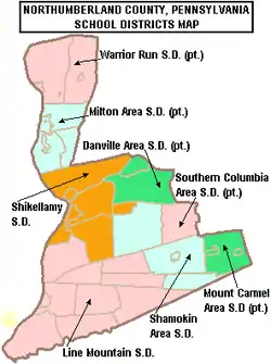
Public school districts
- Danville Area School District (also in Montour County)
- Line Mountain School District
- Milton Area School District (also in Union County)
- Mount Carmel Area School District (also in Columbia County)
- Shamokin Area School District
- Shikellamy School District
- Southern Columbia Area School District (also in Columbia County)
- Warrior Run School District (also in Montour and Union Counties)
Charter school
SusQ Cyber Charter School – provided by Intermediate Unit 16 Grades 9–12th
Career Tech school
Northumberland County Career Technology Center located in Coal Township
Intermediate Unit
Central Susquehanna Intermediate Unit 16 – The primary service area consists of: Columbia, Montour, Northumberland, Snyder and Union counties in central Pennsylvania. Provides a wide variety of education related services to school districts, private and parochial schools and hame schooled students. Funded by: state and federal grants; state contracts and service contracts. Intermediate units do not have the power to levy taxes. The IU's board is made up of representatives from the schools districts it serves.
Independent schools
- Bethesda Alternative School, Milton 7–12th grade
- Keefertown Parochial School 1–8th grade
- Maranatha Mennonite Christian School K-12th grade
- Meadowbrook Christian Academy PreK-12th grade
- Meadowview Christian Academy PreK-10th grade
- Northumberland Christian School PreK-12th grade
- Northwestern Academy 5–12th grade
- Our Lady of Lourdes Regional School preK–12th grade[28]
- Schwaben Creek School 1–8th grade
- Spring View Parochial School, Watsontown 1–9th grade
- St Louis De Monfort Academy, Herdon 7–12 grade[29]
- Sunbury Christian Academy, Northumberland K-12th grade[30]
- Sunny Slope Amish Parochial School 1–8th grade
- Telos Educational Services Tutoring Center, Montandon[31]
- Transfiguration Elementary School, Shamokin PreK-8th grade
- Watsontown Christian Academy, Watsontown PreK-12th grade
data from ies – National Center For Education Statistics – PSS Private School Universe Survey data for the 2007–2008 school year, U.S. Department of Education Institute of Education Sciences[32]
CSIU16 School Directory 2014[33]
Additionally there are nearly 1000 children attending Mennonite and Amish schools per the Central Susquehanna Intermediate Unit 16.[34]
The St Monica School PreK-8th grade which was located in Sunbury Pennsylvania was closed by the Bishop in June 2013.[35]
Child abuse cases reported
In 2014, 1,148 child abuse reports were made to the Northumberland Children and Youth Agency. In 2015, reported cases increased to 2,084, an 82% increase in reports.[36] The increase in cases was attributed to a new state law specifying more professions are mandated reporters, including teachers, college professors, coaches, advisors of youth organizations and public school employees.[37]
Communities
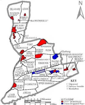
Under Pennsylvania law, there are four types of incorporated municipalities: cities, boroughs, townships, and, in one case, a town. The following cities, boroughs, and townships are located in Northumberland County:
Boroughs
Townships
Census-designated places
Census-designated places are geographical areas designated by the U.S. Census Bureau for the purposes of compiling demographic data. They are not actual jurisdictions under Pennsylvania law. Other unincorporated communities, such as villages, may be listed here as well.
Unincorporated community
Population ranking
The population ranking of the following table is based on the 2010 census of Northumberland County.[38]
† county seat
| Rank | City/Town/etc. | Municipal type | Population (2010 Census) |
|---|---|---|---|
| 1 | † Sunbury | City | 9,905 |
| 2 | Shamokin | City | 7,374 |
| 3 | Milton | Borough | 7,042 |
| 4 | Mount Carmel | Borough | 5,893 |
| 5 | Northumberland | Borough | 3,804 |
| 6 | Kulpmont | Borough | 2,924 |
| 7 | Paxinos | CDP | 2,467 |
| 8 | Edgewood | CDP | 2,384 |
| 9 | Watsontown | Borough | 2,351 |
| 10 | Elysburg | CDP | 2,194 |
| 11 | Fairview-Ferndale | CDP | 2,139 |
| 12 | Riverside | Borough | 1,932 |
| 13 | Trevorton | CDP | 1,834 |
| 14 | Dewart | CDP | 1,471 |
| 15 | Marshallton | CDP | 1,441 |
| 16 | Montandon | CDP | 903 |
| 17 | Kapp Heights | CDP | 863 |
| 18 | Atlas | CDP | 809 |
| 19 | Turbotville | Borough | 705 |
| 20 | Marion Heights | Borough | 611 |
| 21 | Ranshaw | CDP | 510 |
| 22 | Tharptown (Uniontown) | CDP | 498 |
| 23 | Dalmatia | CDP | 488 |
| 24 | Snydertown | Borough | 339 |
| 25 | Herndon | Borough | 324 |
| 26 | McEwensville | Borough | 279 |
| 27 | Strong | CDP | 147 |
Marcellus Shale Impact fee
Northumberland County receives annual payments from the Commonwealth of Pennsylvania from taxes collected on marcellus shale gas drillers.[39] According to an April 2017 report from the Pennsylvania Department of Environmental Protection there are no operating marcellus shale wells in Northumberland County.[40]
- Shale fee funds to Northumberland County
The use of the funds are strictly prescribed by state law.[43] In Northumberland County, the $2,454,592 in marcellus shale fee funds have been used for:
- Carbon Run AMD Remediation Projects - $353,252
- Closure #7 Rehabilitation - $110,480
- Shamokin Creek Flood Mitigation - $110,480
- Concrete and Floodwall Repairs - $228,000
- Butternut Creek Flood Protection - $80,210
- Lake Augusta Stream bank Restoration - $165,000
- Liberty Hollow Run Trail - $94,000
- Coal Township Recreation Center - $188,000
- Boat Launch improvements - $198,550
- Anthracite Outdoor Adventure Area Portal - $215,000
- Anthracite Outdoor Adventure Area Mountain bike trails - $222,100
- Anthracite Outdoor Adventure Area Whaleback Observation Deck - $150,000
Natural gas pipeline
In March 2016, Northumberland County announced a $700,000 deal with Williams Transco pipeline company. The county is granting a 9,700 foot right-of-way through its Anthracite Outdoor Adventure Area recreation park. Two parcels of county owned land are impacted: one in East Cameron Township and the other in Coal Township. The one time payment for the East Cameron Township parcel will be shared: County - 33.27%, township - 42.61% and Shamokin Area School District will receive 24.12%. For the Coal Township parcel: the county receives 33.13%, Coal Township gets 27.86% and the school district receives 39.01%. of the right-of-way payment. The county will also receive the value of the timber taken when the land is stripped. The recreation area is an environmentally restored former coal mining area.[44] The pipeline will strip all vegetation and trees from the right-of-way in the outdoor recreation area. The Atlantic Sunrise Pipeline Project is a 178 mile long project, crossing 10 Pennsylvania counties and impacting 30 property owners in Northumberland County.[45]
References
- "State & County QuickFacts". United States Census Bureau. Archived from the original on June 6, 2011. Retrieved November 20, 2013.
- "Find a County". National Association of Counties. Archived from the original on May 31, 2011. Retrieved June 7, 2011.
- "PA County Code Newspaper Handbook". Pennsylvania Newspaper Association. 2005. Archived from the original on February 25, 2017.
- Archived March 23, 2012, at the Wayback Machine
- Joseph Priestley House Archived July 21, 2011, at the Wayback Machine. Joseph Priestley House. Retrieved on July 23, 2013.
- "2010 Census Gazetteer Files". United States Census Bureau. August 22, 2012. Retrieved March 9, 2015.
- "Population and Housing Unit Estimates". Retrieved October 12, 2018.
- "U.S. Decennial Census". United States Census Bureau. Retrieved March 9, 2015.
- "Historical Census Browser". University of Virginia Library. Archived from the original on August 11, 2012. Retrieved March 9, 2015.
- Forstall, Richard L., ed. (March 24, 1995). "Population of Counties by Decennial Census: 1900 to 1990". United States Census Bureau. Archived from the original on March 20, 2015. Retrieved March 9, 2015.
- "Census 2000 PHC-T-4. Ranking Tables for Counties: 1990 and 2000" (PDF). United States Census Bureau. April 2, 2001. Archived (PDF) from the original on December 18, 2014. Retrieved March 9, 2015.
- "U.S. Census website". United States Census Bureau. Retrieved January 31, 2008.
- Pennsylvania Department of Health, Birth Age County Reports 1990 and 2011, 2011
- US Census Bureau (2015). "Poverty Rates by County Small Area Income and Poverty Estimates". Archived from the original on December 22, 2015.
- Pennsylvania Budget and Policy Center (2012). "Student Poverty Concentration 2012". Archived from the original on December 22, 2015. Retrieved December 11, 2015.
- Emma Ginader., Union Shows Highest spike in food need, The Daily Item, February 17, 2016
- US Census Bureau, 2014 Community Survey, 2015
- Rick Dandes., Fewer Kids Having Kids, The Daily Item, March 13, 2016
- Joseph F. Donnermeyer, PHD (2013). "Amish Settlements across America: 2013" (PDF). Archived (PDF) from the original on March 5, 2016.
- Justin Strawser., Guidelines provide needed stability for foster children, The Daily Item, December 20, 2016
- "Office of Management and Budget". The White House. Archived from the original on April 29, 2018. Retrieved August 5, 2015.
- Center for New Media and Promotions(C2PO). "2010 Census". census.gov. Retrieved August 5, 2015.
- Leip, David. "Dave Leip's Atlas of U.S. Presidential Elections". uselectionatlas.org. Archived from the original on March 23, 2018. Retrieved May 3, 2018.
- Running for Office Archived November 26, 2008, at the Wayback Machine. Dos.state.pa.us. Retrieved on July 23, 2013.
- Leip, David. "Dave Leip's Atlas of U.S. Presidential Elections". uselectionatlas.org.
- Center, Legislativate Data Processing. "Find Your Legislator". The official website for the Pennsylvania General Assembly. Archived from the original on April 28, 2017. Retrieved April 27, 2017.
- "Pennsylvania Department of Education". state.pa.us. Archived from the original on October 9, 2009. Retrieved August 5, 2015.
- "Our Lady of Lourdes ONLINE!". Archived from the original on August 6, 2007.
- "St Louis de Montfort Academy". Archived from the original on December 26, 2013.
- "Sunbury Christian Academy". Archived from the original on February 4, 2014.
- Daily Item.com, New tutoring center opens, April 10, 2016
- "Search for Private Schools - Search Results". ed.gov. Archived from the original on April 2, 2015. Retrieved August 5, 2015.
- "CSIU16 School Directory 2014" (PDF). January 20, 2014. Archived from the original (PDF) on February 23, 2014.
- School Choice Topic of Meeting tonight, Joseph Deinlein, The Daily Item, April 5, 2011
- Nikki Krize (May 31, 2012). "Celebrating Saint Monica School". WNEP TV News. Archived from the original on February 22, 2014.
- John Zaklansky. Increase in referrals, abuse cases. The Daily Item, April 10, 2016
- John Zaklansky. Child Abuse Awareness takes on new meaning. The Daily Item, April 10, 2016
- Promotions, Center for New Media and. "US Census Bureau 2010 Census".
- John Finnerty., Critics Fear tax hike may hurt projects, The Daily Item, March 5, 2017
- PA Department of Environmental Protection (April 2017). "Oil & Gas Reporting Website - Production - Waste Reports".
- PUC (2017). "Local Government Impact Fee Distributions". Archived from the original on February 4, 2017.
- Pennsylvania Utility Commission (2015). "County Disbursement for 2015". Archived from the original on July 2, 2017.
- PUC (2017). "Act 13 (Impact Fee)". Archived from the original on March 15, 2016.
- Justin Strawser., Deal gives county $700K, The Dailiy Item, March 4, 2016
- Williams, Transco Atlantic Sunrise Pipeline Project, 2015
External links
Municipalities and communities of Northumberland County, Pennsylvania, United States | ||
|---|---|---|
| Cities | | |
| Boroughs | ||
| Townships | ||
| CDPs | ||
| Unincorporated communities | ||
| ||

| Authority control |
|---|