Venango County, Pennsylvania
Venango County is a county located in the Commonwealth of Pennsylvania. As of the 2010 census, the population was 54,984.[1] Its county seat is Franklin.[2] The county was created in 1800 and later organized in 1805.[3]
Venango County | |
|---|---|
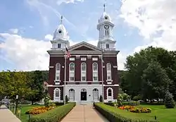 Venango County Courthouse | |
 Seal | |
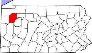 Location within the U.S. state of Pennsylvania | |
 Pennsylvania's location within the U.S. | |
| Coordinates: 41°24′N 79°46′W | |
| Country | |
| State | |
| Founded | September 1, 1805 |
| Named for | Native American word for otter |
| Seat | Franklin |
| Largest city | Oil City (population) Sugarcreek (area) |
| Area | |
| • Total | 683 sq mi (1,770 km2) |
| • Land | 674 sq mi (1,750 km2) |
| • Water | 8.6 sq mi (22 km2) 1.3%% |
| Population | |
| • Estimate (2018) | 51,266 |
| • Density | 79/sq mi (31/km2) |
| Time zone | UTC−5 (Eastern) |
| • Summer (DST) | UTC−4 (EDT) |
| Congressional district | 15th |
| Website | www |
Venango County comprises the Oil City, PA Micropolitan Statistical Area. It is defined as part of the Pittsburgh media market.
History
Venango County was created on March 12, 1800 from parts of Allegheny and Lycoming Counties. The name "Venango" comes from the Native American name of the region, Onenge, meaning Otter. This was corrupted in English as the Venango River.[4] The settlement at its mouth was likewise called Venango, and is the site of present-day South Side of Oil City, Pennsylvania.
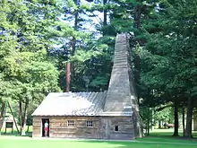
Venango County was home to an oil boom in the years following discovery of natural oil (petroleum) in the mid-1850s.
George Bissell, a Yale University Chemistry professor, and Edwin L. Drake, a former railroad conductor, made the first successful use of a drilling rig on August 28, 1859 near Titusville, Pennsylvania. (Although Titusville is in Crawford County, the first oil well was drilled outside of town, less than a mile inside of the Venango County boundary.) This single well soon exceeded the entire cumulative oil output of Europe since the 1650s. Within weeks oil derricks were erected all over the area. Other oil boom towns located in Venango County included Franklin, Oil City, and the now defunct Pithole City. The principal product of the oil was kerosene.
McClintocksville was a small community in Cornplanter Township in Venango County. In 1861, it was the location of Wamsutta Oil Refinery, the first business venture of Henry Huttleston Rogers, who became a leading United States capitalist, businessman, industrialist, financier, and philanthropist. Rogers and his young wife Abbie Palmer Gifford Rogers lived in a one-room shack there along Oil Creek for several years beginning in 1862.
_pic.088_Oil_Rush_in_Venango_County%252C_PA%252C_in_1866.jpg.webp)
Shortly later, Rogers met oil pioneer Charles Pratt who purchased the entire output of the tiny Wamsutta Oil Refinery. In 1867, Rogers joined Pratt in forming Charles Pratt and Company, which was purchased by Standard Oil in 1874. Rogers became one of the key men in John D. Rockefeller's Standard Oil Trust.
After joining Standard Oil, Rogers invested heavily in various industries, including copper, steel, mining, and railways. The Virginian Railway is widely considered his final life's achievement. Rogers amassed a great fortune, estimated at over $100 million, and became one of the wealthiest men in the United States. He was also a generous philanthropist, providing many public works for his hometown of Fairhaven, Massachusetts, and financially assisting helping such notables as Mark Twain, Helen Keller, and Dr. Booker T. Washington.
Perhaps in one of history's ironies, another resident of Venango County about the same time as Henry and Abbie Rogers was a little girl named Ida M. Tarbell, whose father was an independent producer whose small business was ruined by the South Improvement Company scheme of 1871 and the conglomerate which became Standard Oil. Introduced to each other in 1902 by their mutual friend Mark Twain, Tarbell who had become an investigative journalist and Rogers, who knew of her work, shared meetings and information over a two-year period which led to her epoch work, The History of the Standard Oil Company, published in 1904, which many historians feel helped fuel public sentiment against the giant company and helped lead to the court-ordered break-up of it in 1911.
The oil heritage of Venanago County is remembered by a Pennsylvania State Park and many heritage sites which help tell the story and memorialize the people of the oil boom of the late 19th and early 20th centuries.
Geography
According to the U.S. Census Bureau, the county has a total area of 683 square miles (1,770 km2), of which 674 square miles (1,750 km2) is land and 8.6 square miles (22 km2) (1.3%) is water.[5]
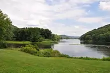
French Creek is formed near French Creek, New York and extends for a length of 117 miles (188 km) with a drainage area of 1,270 square miles (3,289 km2). It joins the Allegheny River near Franklin, Pennsylvania. The watershed area includes parts of Erie, Crawford, Venango, and Mercer Counties in Pennsylvania as well as Chautauqua County, New York.
Adjacent counties
- Crawford County (northwest)
- Warren County (north)
- Forest County (northeast)
- Clarion County (east)
- Butler County (south)
- Mercer County (west)
Demographics
| Historical population | |||
|---|---|---|---|
| Census | Pop. | %± | |
| 1800 | 1,130 | — | |
| 1810 | 3,060 | 170.8% | |
| 1820 | 4,915 | 60.6% | |
| 1830 | 9,470 | 92.7% | |
| 1840 | 17,900 | 89.0% | |
| 1850 | 18,310 | 2.3% | |
| 1860 | 25,043 | 36.8% | |
| 1870 | 47,925 | 91.4% | |
| 1880 | 43,670 | −8.9% | |
| 1890 | 46,640 | 6.8% | |
| 1900 | 49,648 | 6.4% | |
| 1910 | 56,359 | 13.5% | |
| 1920 | 59,184 | 5.0% | |
| 1930 | 63,226 | 6.8% | |
| 1940 | 63,958 | 1.2% | |
| 1950 | 65,328 | 2.1% | |
| 1960 | 65,295 | −0.1% | |
| 1970 | 62,353 | −4.5% | |
| 1980 | 64,444 | 3.4% | |
| 1990 | 59,381 | −7.9% | |
| 2000 | 57,555 | −3.1% | |
| 2010 | 54,984 | −4.5% | |
| 2018 (est.) | 51,266 | [6] | −6.8% |
| U.S. Decennial Census[7] 1790–1960[8] 1900–1990[9] 1990–2000[10] 2010–2017[1] | |||

As of the census[11] of 2000, there were 57,565 people, 22,747 households, and 15,922 families residing in the county. The population density was 85 people per square mile (33/km2). There were 26,904 housing units at an average density of 40 per square mile (15/km2). The racial makeup of the county was 97.64% White, 1.09% Black or African American, 0.18% Native American, 0.23% Asian, 0.02% Pacific Islander, 0.17% from other races, and 0.67% from two or more races. 0.52% of the population were Hispanic or Latino of any race. 43.9% English or Welsh, 12.5% were of German, 11.1% American, 9.9% Irish, 8.3% Scotch-Irish, 2.8% Dutch, 2.1% Italian, and 1.6% French ancestry.
There were 22,747 households, out of which 30.40% had children under the age of 18 living with them, 55.80% were married couples living together, 9.90% had a female householder with no husband present, and 30.00% were non-families. 26.20% of all households were made up of individuals, and 12.50% had someone living alone who was 65 years of age or older. The average household size was 2.45 and the average family size was 2.93.
In the county, the population was spread out, with 24.20% under the age of 18, 7.20% from 18 to 24, 26.70% from 25 to 44, 25.10% from 45 to 64, and 16.80% who were 65 years of age or older. The median age was 40 years. For every 100 females there were 95.40 males. For every 100 females age 18 and over, there were 92.10 males.
Micropolitan Statistical Area
The United States Office of Management and Budget[12] has designated Venango County as the Oil City, PA Micropolitan Statistical Area (µSA).[13] As of the 2010 U.S. Census[14] the micropolitan area ranked 9th most populous in the State of Pennsylvania and the 182nd most populous in the United States with a population of 54,984.
Law and government
| Year | Republican | Democratic | Third parties |
|---|---|---|---|
| 2020 | 70.0% 18,569 | 28.6% 7,585 | 1.4% 374 |
| 2016 | 68.1% 16,021 | 26.8% 6,309 | 5.1% 1,200 |
| 2012 | 62.1% 13,815 | 35.7% 7,945 | 2.2% 497 |
| 2008 | 58.4% 13,718 | 39.3% 9,238 | 2.2% 525 |
| 2004 | 61.2% 14,472 | 38.1% 9,024 | 0.7% 163 |
| 2000 | 56.7% 11,642 | 39.9% 8,196 | 3.4% 703 |
| 1996 | 43.0% 8,398 | 42.0% 8,205 | 15.1% 2,946 |
| 1992 | 39.6% 8,545 | 38.2% 8,230 | 22.2% 4,779 |
| 1988 | 56.6% 11,468 | 42.6% 8,624 | 0.8% 171 |
| 1984 | 59.4% 13,507 | 40.1% 9,114 | 0.5% 104 |
| 1980 | 56.0% 11,547 | 37.9% 7,800 | 6.1% 1,257 |
| 1976 | 57.6% 12,270 | 40.6% 8,653 | 1.8% 388 |
| 1972 | 67.3% 13,991 | 30.3% 6,302 | 2.4% 501 |
| 1968 | 56.1% 12,323 | 37.9% 8,319 | 6.0% 1,307 |
| 1964 | 42.9% 9,873 | 56.8% 13,065 | 0.4% 84 |
| 1960 | 68.0% 17,193 | 31.9% 8,064 | 0.1% 23 |
| 1956 | 75.3% 17,107 | 24.6% 5,594 | 0.1% 14 |
| 1952 | 72.2% 17,006 | 27.0% 6,356 | 0.9% 204 |
| 1948 | 68.0% 11,920 | 29.3% 5,144 | 2.7% 472 |
| 1944 | 68.9% 14,916 | 29.7% 6,426 | 1.4% 304 |
| 1940 | 71.9% 17,728 | 27.9% 6,873 | 0.2% 57 |
| 1936 | 64.1% 17,676 | 33.4% 9,212 | 2.5% 677 |
| 1932 | 64.1% 12,230 | 32.3% 6,174 | 3.6% 684 |
| 1928 | 79.0% 17,450 | 20.5% 4,531 | 0.5% 108 |
| 1924 | 74.3% 10,841 | 12.9% 1,886 | 12.8% 1,865 |
| 1920 | 65.7% 7,718 | 22.7% 2,669 | 11.6% 1,359 |
| 1916 | 41.0% 3,856 | 41.9% 3,938 | 17.2% 1,616 |
| 1912 | 18.3% 1,660 | 27.6% 2,507 | 54.2% 4,925 |
| 1908 | 49.7% 4,868 | 28.8% 2,815 | 21.5% 2,105 |
| 1904 | 57.3% 5,892 | 17.0% 1,747 | 25.7% 2,639 |
| 1900 | 52.8% 5,931 | 35.7% 4,014 | 11.6% 1,299 |
| 1896 | 49.8% 5,133 | 44.6% 4,599 | 5.6% 572 |
| 1892 | 49.3% 4,099 | 39.6% 3,288 | 11.1% 926 |
| 1888 | 50.5% 4,424 | 39.7% 3,475 | 9.9% 863 |
Venango County has long been powerfully Republican. Only twice since the Civil War has the county selected a Democratic presidential candidate, and only Lyndon Johnson in his 1964 landslide has gained an absolute majority for the Democratic Party. In 1984 Venango County actually voted fractionally more Democratic than the nation at-large due to hostility towards Reaganomics in industrial districts, but by 2016 Donald Trump had gained 68.1 percent to Hillary Clinton's 26.8 percent – figures which were long typical of the county.
County Commissioners
- Samuel H. Breene (Republican)
- Michael C. Dulaney (Republican)
- Albert "Chip" Abramovic (Democrat)
State Senate[16]
State House of Representatives[16]
United States House of Representatives
United States Senate
Economy
Major employers
Pennzoil and Quaker State left the Venango area for Texas. After leaving the area they merged and stopped refining oil. They now concentrate on retail oil and automotive additives produced for them by other companies. As of 2007, the two companies only exist as brand names after the company disappeared because of successive mergers.
With global crude oil prices touching US$100 in early 2008, long-dormant interest reawakened in Venango County's remaining oil reserves, 70% undrilled by one estimate. High prices make less accessible oil deposits worth extracting. For instance, a Canadian firm proposed drilling several large mines and allowing oil to flood the tunnels.[17]
Education
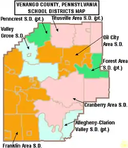
Public school districts
Partial districts
These public school districts are only partially in Venango County:
Colleges and universities
Transportation
Airport
Recreation
Pennsylvania State Parks and Forests
Attractions and tourism
- DeBence Antique Music World
- Oil Region Astronomical Observatory
- Franklin Silver Cornet Band
- Franklin Public Library. The Franklin Public Library was founded in 1894 and has had several homes, although its current location on Twelfth Street in Franklin, Venango County, PA has been its home since 1921. The original structure on Twelfth Street was built in 1849 as a residence and required extensive renovations in 1921 to make it suitable for library use.
Communities
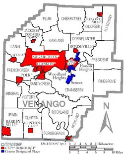
Under Pennsylvania law, there are four types of incorporated municipalities: cities, boroughs, townships, and, in at most two cases, towns. The following cities, boroughs and townships are located in Venango County:
Boroughs
Townships
Census-designated places
Census-designated places are geographical areas designated by the U.S. Census Bureau for the purposes of compiling demographic data. They are not actual jurisdictions under Pennsylvania law. Other unincorporated communities, such as villages, may be listed here as well.
Unincorporated communities
- Bredinsburg
- Cranberry
- Dempseytown
- Fertigs
- Petroleum Center
- Raymilton
- Siverly[18]
- Venus
Population ranking
The population ranking of the following table is based on the 2010 census of Venango County.[14]
† county seat
| Rank | City/Town/etc. | Municipal type | Population (2018 Census) |
|---|---|---|---|
| 1 | Oil City | City | 9,897 |
| 2. | Cranberry | Township | 6,789 |
| 3 | † Franklin | City | 6,231 |
| 4 | Sugar Creek | Borough | 5,008 |
| 5. | Cornplanter | Township | 2,316 |
| 6 | Hasson Heights | CDP | 1,437 |
| 7 | Woodland Heights | CDP | 1,726 |
| 8 | Cherrytree | Township | 1,378 |
| 9 | Seneca | CDP | 1,289 |
| 10 | Pleasantville | Borough | 887 |
| 11 | Polk | Borough | 826 |
| 12 | Emlenton (partially in Clarion County) | Borough | 625 |
| 13 | Rouseville | Borough | 523 |
| 14 | Clintonville | Borough | 508 |
| 15 | Cooperstown | Borough | 460 |
| 16 | Kennerdell | CDP | 247 |
| 17 | Barkeyville | Borough | 207 |
| 18 | Utica | Borough | 189 |
| 19 | Hannasville | CDP | 176 |
Notable people
- Orrin Dubbs Bleakley
- Cornplanter
- William Holmes Crosby, Jr.
- Hildegarde Dolson
- Frank Evans
- Gabby Gabreski
- Leon H. Gavin
- Alexander Hays
- Kathryn Kuhlman
- Judge Robert Lamberton
- Ted Marchibroda
- Jesse L. Reno
- George C. Rickards
- Henry H. Rogers
- Joseph Sibley
- Peter Moore Speer
- Ida M. Tarbell
- John Wesley Van Dyke
See also
References
- "State & County QuickFacts". United States Census Bureau. Retrieved November 22, 2013.
- "Find a County". National Association of Counties. Retrieved June 7, 2011.
- "Pennsylvania: Individual County Chronologies". Pennsylvania Atlas of Historical County Boundaries. The Newberry Library. 2008. Retrieved March 13, 2015.
- Donehoo, George (1995). "French Creek". Indian Villages and Place Names in Pennsylvania. Gateway Press. Retrieved January 24, 2007.
- "2010 Census Gazetteer Files". United States Census Bureau. August 22, 2012. Retrieved March 11, 2015.
- "Population and Housing Unit Estimates". Retrieved October 17, 2018.
- "U.S. Decennial Census". United States Census Bureau. Retrieved March 11, 2015.
- "Historical Census Browser". University of Virginia Library. Retrieved March 11, 2015.
- Forstall, Richard L., ed. (March 24, 1995). "Population of Counties by Decennial Census: 1900 to 1990". United States Census Bureau. Retrieved March 11, 2015.
- "Census 2000 PHC-T-4. Ranking Tables for Counties: 1990 and 2000" (PDF). United States Census Bureau. April 2, 2001. Retrieved March 11, 2015.
- "U.S. Census website". United States Census Bureau. Retrieved May 14, 2011.
- "Office of Management and Budget – The White House". Retrieved November 29, 2018.
- "Archived copy". Archived from the original on September 24, 2015. Retrieved December 7, 2017.CS1 maint: archived copy as title (link)
- CNMP, US Census Bureau. "This site has been redesigned and relocated. – U.S. Census Bureau". census.gov. Retrieved November 29, 2018.
- Leip, David. "Dave Leip's Atlas of U.S. Presidential Elections". uselectionatlas.org. Retrieved November 29, 2018.
- Center, Legislativate Data Processing. "Find Your Legislator". The official website for the Pennsylvania General Assembly. Retrieved May 9, 2017.
- "As Oil Prices Soar, Prospectors Return to Pennsylvania". The Wall Street Journal. February 19, 2008. Archived from the original on February 28, 2008. Retrieved February 25, 2008.
- "Siverly Populated Place Profile / Venango County, Pennsylvania Data". pennsylvania.hometownlocator.com. Retrieved November 29, 2018.
External links
| Wikimedia Commons has media related to Venango County, Pennsylvania. |
- Venango County Government Home Page
- Venango County interactive map
- Franklin Area Chamber of Commerce
- Venango County History and Genealogy Archive
- Venango Area Chamber of Commerce
Municipalities and communities of Venango County, Pennsylvania, United States | ||
|---|---|---|
| Cities | | |
| Boroughs | ||
| Townships | ||
| CDPs | ||
| Unincorporated communities | ||
| Ghost town | ||
| Footnotes | ‡This populated place also has portions in an adjacent county or counties | |
| ||

| Authority control |
|---|