Pershore
Pershore is a market town in Worcestershire, England, on the banks of the River Avon. Pershore is in the Wychavon district and is part of the West Worcestershire parliamentary constituency. At the 2011 census the population was 7,125. The town is best known for Pershore Abbey, Pershore College (now a campus of Warwickshire College), and the plums[2] and pears grown locally.
| Pershore | |
|---|---|
 High Street, Pershore | |
 Pershore Location within Worcestershire | |
| Population | 7,125 |
| OS grid reference | SO945455 |
| • London | 104.5 miles (168.2 km) |
| Civil parish |
|
| District | |
| Shire county | |
| Region | |
| Country | England |
| Sovereign state | United Kingdom |
| Post town | PERSHORE |
| Postcode district | WR10 |
| Dialling code | 01386 |
| Police | West Mercia |
| Fire | Hereford and Worcester |
| Ambulance | West Midlands |
| UK Parliament | |
| Website | http://pershorepage.com |
Pershore is situated on the River Avon, 6 miles west of Evesham and 6 miles east of Upton-upon-Severn in the Vale of Evesham, a district rich in fruit and vegetable production The town lies near the A44 midway from Worcester to Evesham. The nearest motorway junctions are junction 7 of the M5 (South Worcester) or junction 1 of the M50. There is a railway station on the Cotswold Line, enabling direct travel to Paddington station, London, via Evesham, Moreton-in-Marsh, Oxford, Didcot and Reading, although Pershore station is more than a mile from the centre of the town towards Pinvin.
Bus services in Pershore are operated by First Midland Red, Astons Coaches and N.N. Cresswell with links to Evesham, Stratford and Worcester.
History
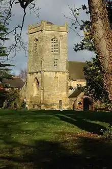
The town contains much elegant Georgian architecture. In 1964 the Council for British Archaeology included Pershore in its list of 51 British "Gem Towns" worthy of special consideration for historic preservation,[3] and it has been listed as an outstanding conservation area. Parts of the abbey, which stand in an expanse of public grassland close to the centre of the town, date from the 11th century. The current structure is far smaller than the original building, which was plundered during the reign of Henry VIII at the Dissolution. The original nave was destroyed. The north transept collapsed later. The present nave occupies the western part of what would originally have been the choir.
Education
Schools in Pershore follow the three-tier first school (ages 5–9), middle school (ages 9–12), high school (ages 12–18) system practised by parts of Worcestershire County Council. Pershore High School has a sixth form with all-weather sports pitches and sports hall.
Abbey Park First School and Abbey Park Middle School are on Abbey Road, they are both situated down the same drive. Pershore High School is on Station Road, which is on the outskirts of Pershore, bordering Pinvin, a small village.
Holy Redeemer Roman Catholic Primary School, situated on Priest Lane beside Holy Redeemer, Pershore's only Catholic church, stands outside the 3-tier model. It is a primary school (ages 5–11) which acts as a feeder school to Blessed Edward Oldcorne Catholic College in Worcester.
Pershore College, a school of horticulture and other land-based activities,[4] became a campus for Warwickshire College (now WCG) following a merger in 2007.
Arts
The town has a community arts centre, a Volunteer Centre, and a morris dance tradition.[5]
Annual events
Plum Festival
The Pershore Plum Festival is held in August to celebrate the local tradition of growing plums including the local varieties Pershore Purple, Pershore Yellow Egg Plum and Pershore Emblem.[2] Activities include crowning the plum princess, a family fun run, plum themed art exhibition and the Plum Fayre. There is also a classic car rally and nearby Worcester Racecourse revived The Land O'Plums Chase from 72 years ago.[6] The festival won the Best Tourism Event and Festival in the Worcestershire Welcome Awards 2011.[7]
Pershore Carnival
On the spring bank holiday, usually the last Monday in May, a carnival is held for the entertainment and enjoyment of the townsfolk and people from a wide surrounding area. Each year has a different theme, the programme covers being designed by children attending Pershore schools. The day starts with a procession of a variety of entries that passes through the town ending at Abbey Park. During the procession a bucket collection is taken in support of the year's two carnival charities. In the park there are stalls, a show arena, a dog show and other attractions, each year being different. The day ends with an evening concert and firework display. Various fundraising events take place prior to the carnival, such as a quiz night, a race night and a duck race on the river.
Sport
Pershore's football club, Pershore Town F.C., play in the West Midlands (Regional) League Premier Division. It also has a women's team, Pershore Town Ladies, who play in the new Herefordshire and Worcestershire Women's County Football League. Pershore Sports club, which houses Pershore Cricket Club who play in the Birmingham and District League, is situated at The Bottoms on Defford Road. Pershore Rugby Club has a clubhouse and pitches by the river in nearby Wyre Piddle. Multiple BTCC title winning team, Team Dynamics, is also based there. Wychavon Kayak & Canoe Club [8] is situated on the river at Pershore Riverside Centre. Pershore Plum Plodders is an England Athletics affiliated running club serving Pershore and the surrounding villages. The Abbey Park includes a bowls club, children's play area and skateboard park (2006), consisting of a mini ramp and a street section. Pershore Tennis Club, based at the Horticultural College, has three indoor and five outdoor courts, with junior, social and adult sections.
Economy
The high street has retail and food outlets, just off the High Street is a covered market and there are two supermarkets, one in the town and one on the outskirts.
Pershore Old Bridge
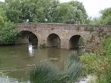
About 0.5 miles (0.80 km) outside the town is Pershore Old Bridge over the River Avon. A bridge was originally built on the site, in about 1413, by monks, supposedly after their abbot, Upton, was drowned falling from stepping-stones. The scene is included in the historical window installed in 1862–64 in Pershore Abbey.
In 1644, during the English Civil War, a later bridge was damaged and almost destroyed. In subsequent years the bridge was maintained by re-using stones from nearby Elmley Castle and from the abbey. In 1926 the bridge was taken out of service for road traffic and is now used only as a footbridge.
Notable people
See also Category:People from Pershore
Natives
- Hugh Bennett (1862–1943), cricketer.
- Claude Choules (1901–2011), was the world's last living veteran of both world wars and supercentenarian.
- Giles Collier (1622–1678), Anglican divine.
- George Dowty (1901–1975), inventor and businessman.
- Florence Feek (1876-1940)[9] Suffragette
- George Mason I (1629–1686), progenitor of the politically significant Mason family in America.
Residents
- Nigel Clark, singer with pop band Dodgy[10]
- Michael Collie (1966–present), TV presenter, BBC Midlands Today.
- Kay Kinsman, (1909-1998), visual artist and mature student at Bishop's University, Lennoxville, Quebec
- Maurice McCanlis (1906–1991), sportsman.
- Charles Shadwell (1898–1979), musician.
- Toyah Willcox, actor and singer, and her husband Robert Fripp of rock band King Crimson.[11]
- Ian Catskilkin, guitarist with alt pop band Art Brut
- Lee Jackson, drummer with punk rock noiseniks Fights and Fires
Twin towns
Pershore is twinned with Bad Neustadt an der Saale in Germany and Plouay in France.
Climate
Like much of the British Isles, Pershore has a temperate maritime climate. Maximums range from 7.7 °C (45.9 °F) in January to 22.4 °C (72.3 °F) in July and minimums from 1.7 °C (35.1 °F) in January and February to 11.9 °C (53.4 °F) in August.[12] The January record high strangely occurred when it was dark; On 9 January 2015, temperatures rose to 16.1 °C (61.0 °F).[13] On 12 December 1981 the lowest reading of −22.0 °C (−7.6 °F) was recorded.[14] The warmest temperature ever recorded was 35.6 °C (96.1 °F) on 3 August 1990.[15] On 30 March 2017, Pershore recorded its warmest March day on record, beating the previous record set in 2012.[16]
| Climate data for Pershore 35m amsl (1991–2020) (extremes 1973–present) | |||||||||||||
|---|---|---|---|---|---|---|---|---|---|---|---|---|---|
| Month | Jan | Feb | Mar | Apr | May | Jun | Jul | Aug | Sep | Oct | Nov | Dec | Year |
| Record high °C (°F) | 16.1 (61.0) |
18.8 (65.8) |
21.1 (70.0) |
26.0 (78.8) |
28.4 (83.1) |
34.0 (93.2) |
34.8 (94.6) |
35.6 (96.1) |
28.8 (83.8) |
28.4 (83.1) |
18.6 (65.5) |
16.0 (60.8) |
35.6 (96.1) |
| Mean maximum °C (°F) | 13.1 (55.6) |
13.7 (56.7) |
16.8 (62.2) |
20.5 (68.9) |
24.8 (76.6) |
27.7 (81.9) |
29.2 (84.6) |
28.3 (82.9) |
24.4 (75.9) |
20.1 (68.2) |
15.6 (60.1) |
13.7 (56.7) |
29.8 (85.6) |
| Average high °C (°F) | 7.7 (45.9) |
8.6 (47.5) |
11.1 (52.0) |
14.1 (57.4) |
16.6 (61.9) |
20.0 (68.0) |
22.4 (72.3) |
21.4 (70.5) |
19.3 (66.7) |
14.9 (58.8) |
10.8 (51.4) |
7.9 (46.2) |
14.6 (58.2) |
| Daily mean °C (°F) | 4.7 (40.5) |
5.2 (41.4) |
6.9 (44.4) |
9.3 (48.7) |
11.8 (53.2) |
15.0 (59.0) |
17.0 (62.6) |
16.7 (62.1) |
14.5 (58.1) |
11.0 (51.8) |
7.5 (45.5) |
4.9 (40.8) |
10.4 (50.7) |
| Average low °C (°F) | 1.7 (35.1) |
1.7 (35.1) |
2.7 (36.9) |
4.4 (39.9) |
6.9 (44.4) |
9.9 (49.8) |
11.6 (52.9) |
11.9 (53.4) |
9.6 (49.3) |
7.0 (44.6) |
4.1 (39.4) |
1.8 (35.2) |
6.1 (43.0) |
| Mean minimum °C (°F) | −5.5 (22.1) |
−5.1 (22.8) |
−3.6 (25.5) |
−2.3 (27.9) |
0.3 (32.5) |
3.9 (39.0) |
6.7 (44.1) |
5.7 (42.3) |
2.4 (36.3) |
0.2 (32.4) |
−3.2 (26.2) |
−5.7 (21.7) |
−8.1 (17.4) |
| Record low °C (°F) | −19.4 (−2.9) |
−12.7 (9.1) |
−9.4 (15.1) |
−7.3 (18.9) |
−2.5 (27.5) |
−1.0 (30.2) |
2.7 (36.9) |
0.0 (32.0) |
−1.0 (30.2) |
−5.1 (22.8) |
−10.5 (13.1) |
−22.0 (−7.6) |
−22.0 (−7.6) |
| Average rainfall mm (inches) | 52.2 (2.06) |
38.2 (1.50) |
36.6 (1.44) |
42.3 (1.67) |
50.8 (2.00) |
46.5 (1.83) |
49.7 (1.96) |
53.9 (2.12) |
46.6 (1.83) |
63.5 (2.50) |
58.5 (2.30) |
52.3 (2.06) |
591.1 (23.27) |
| Average rainy days (≥ 1.0 mm) | 11.1 | 9.5 | 8.8 | 8.7 | 8.3 | 9.0 | 8.5 | 9.2 | 7.7 | 10.6 | 10.5 | 10.9 | 112.8 |
| Average relative humidity (%) | 85.6 | 82.6 | 77.3 | 73.7 | 72.2 | 71.0 | 71.5 | 73.7 | 77.0 | 79.3 | 83.4 | 86.9 | 77.9 |
| Mean monthly sunshine hours | 63.9 | 84.0 | 126.0 | 159.1 | 195.9 | 190.9 | 197.2 | 174.5 | 136.9 | 101.1 | 65.8 | 61.2 | 1,556.5 |
| Percent possible sunshine | 24.5 | 29.7 | 34.2 | 37.9 | 40.3 | 38.1 | 39.3 | 38.6 | 36.2 | 30.8 | 24.9 | 25.3 | 33.3 |
| Source 1: Met Office[17] | |||||||||||||
| Source 2: en.tutiempo[18][16][19][20][21] | |||||||||||||
References
- http://www.pershoretowncouncil.gov.uk/
- "About Pershore Plums". Retrieved 2 September 2011.
- http://isgap.org.uk/gem-towns
- "Warwickshire College Group | Colleges | Pershore College | Study options |". www.warwickshire.ac.uk. Retrieved 3 June 2017.
- Pershore Morrismen,
- "Pershore Plum Festival". Retrieved 2 September 2011.
- "Best Tourism Event and Festival in the Worcestershire Welcome Awards 2011". Archived from the original on 7 September 2011. Retrieved 2 September 2011.
- Wychavon Kayak & Canoe Club
- "Casualty". www.cwgc.org. Retrieved 19 October 2019.
- "Nigel Clark | Free Music, Mixes, Tour Dates, Photos, Videos". Uk.myspace.com. Archived from the original on 10 January 2013. Retrieved 15 June 2013.
- "Toyah at Taste of Pershore". Evesham Journal. 18 October 2007.
- http://en.tutiempo.net/climate/ws-35290.html
- https://en.tutiempo.net/climate/01-2015/ws-35290.html
- https://en.tutiempo.net/climate/12-1981/ws-35290.html
- "Climate, Pershore". tutiempo.net. Retrieved 8 December 2015.
- http://www.metoffice.gov.uk/public/weather/observation/map/gcq8uy4x6#?zoom=9&map=SatelliteVis&fcTime=1490929200&lon=-1.90&lat=52.20
- "Pershore Climate Period: 1981–2010". Met Office. Retrieved 5 July 2020.
- http://en.tutiempo.net/climate/ws-35290.html
- http://www.metoffice.gov.uk/climatechange/science/monitoring/ukcp09/download/longterm/fivekm_monthly.html
- https://www.google.co.uk/search?newwindow=1&safe=off&rlz=1C1CHBF_en-GBGB784GB784&ei=CBOMW7-7COTQgAbztLjgAQ&q=pershore+climate&oq=pershore+climate&gs_l=psy-ab.3..0.787.787.0.1485.1.1.0.0.0.0.55.55.1.1.0....0...1.1.64.psy-ab..0.1.53....0.Jq181MqRUFI
- http://www.bablakeweather.co.uk/1991-2020-30-year-averages
External links
| Wikimedia Commons has media related to Pershore. |
- Pershore Tourist Information
- . Encyclopædia Britannica (11th ed.). 1911.
| Authority control |
|---|