Picogen
Picogen is a rendering system for the creation and rendering of artificial terrain, based on ray tracing. It is free software.
 | |
| Developer(s) | Sebastian Mach |
|---|---|
| Stable release | 0.3
/ July 20, 2010 |
| Repository | |
| Written in | C++ |
| Operating system | Linux, Windows |
| Platform | Cross-platform |
| Type | Scenery generator |
| License | GPL, Version 3, or newer |
| Website | picogen |

Overview
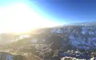
While the primary purpose of picogen is to display realistic 3D terrain, both in terms of terrain formation and image plausibility, it also is a heightmap-creation tool,[1] in which heightmaps are programmed in a syntax reminiscent of Lisp.[2]
Example features
- Whitted-Style ray tracer for quick previews
- Rudimentary path tracer for high quality results
- Partial implementation of Preetham's Sun-/Skylight Model [4]
- Procedural heightmaps, though before rendering they are tesselated
Frontends
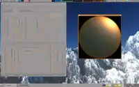
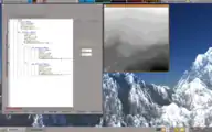
Currently there is a frontend to picogen, called picogen-wx (based on wxWidgets). It is encapsulated from picogen and thus communicates with it on command-line level. Picogen-wx provides several panels to design the different aspects of a landscape, e.g. the Sun/Sky- or the Terrain-Texture-Panel. Each panel has its own preview window, though each preview window can be reached from any other panel.
Landscapes can be loaded and saved through an own, simple XML-based file format, and images of arbitrary size (including antialiasing) can be saved.
References
External links
- Official website
- picogens DeviantArt-Group-Page
| Open-source | 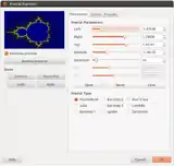 | ||||
|---|---|---|---|---|---|
| GNU | |||||
| Freeware | |||||
| Retail |
| ||||
| Scenery generator | |||||
| Found objects | |||||
| Related | |||||
| |||||