Placer, Masbate
Placer, officially the Municipality of Placer, is a 2nd class municipality in the province of Masbate, Philippines. According to the 2015 census, it has a population of 55,826 people. [3]
Placer | |
|---|---|
| Municipality of Placer | |
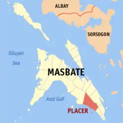 Map of Masbate with Placer highlighted | |
OpenStreetMap 
| |
.svg.png.webp) Placer Location within the Philippines | |
| Coordinates: 11°52′N 123°55′E | |
| Country | |
| Region | Bicol Region (Region V) |
| Province | Masbate |
| District | 3rd district |
| Founded | 1948 |
| Barangays | 35 (see Barangays) |
| Government | |
| • Type | Sangguniang Bayan |
| • Mayor | Eusebio Dumoran Jr. |
| • Vice Mayor | Alito D. Quilongquilong |
| • Representative | Wilton T. Kho |
| • Electorate | 35,994 voters (2019) |
| Area | |
| • Total | 193.03 km2 (74.53 sq mi) |
| Elevation | 8.0 m (26.2 ft) |
| Population | |
| • Total | 55,826 |
| • Density | 290/km2 (750/sq mi) |
| • Households | 11,934 |
| Economy | |
| • Income class | 2nd municipal income class |
| • Poverty incidence | 47.22% (2015)[4] |
| • Revenue | ₱129,181,999.42 (2016) |
| Time zone | UTC+8 (PST) |
| ZIP code | 5408 |
| PSGC | |
| IDD : area code | +63 (0)56 |
| Climate type | tropical rainforest climate |
| Native languages | Cebuano Masbateño language Tagalog |
| Website | www |
By virtue of Republic Act No. 292, passed on June 16, 1948, the barrio of Placer was constituted as its own municipality, separate from Cataingan. At the time of its creation, Placer included the entire present-day municipality of Esperanza, which was then a barrio of Placer (its largest barrio).[5] It is one of the only two municipalities in Masbate which is dominantly Cebuano-speaking, the other being the adjacent municipality of Esperanza; Esperanza separated from Placer in 1959.[6]
Barangays
Placer is politically subdivided into 35 barangays. [2]
- Aguada
- Ban-Ao
- Burabod
- Cabangcalan
- Calumpang
- Camayabsan
- Daanlungsod
- Dangpanan
- Daraga
- Guin-Awayan
- Guinhan-Ayan
- Katipunan
- Libas
- Locso-An
- Luna
- Mahayag
- Mahayahay
- Manlut-Od
- Matagantang
- Naboctot
- Nagarao
- Nainday
- Naocondiot
- Pasiagon
- Pili
- Poblacion
- Puro
- Quibrada
- San Marcos
- Santa Cruz
- Taboc
- Tan-Awan
- Taverna
- Tubod
- Villa
Climate
| Climate data for Placer, Masbate | |||||||||||||
|---|---|---|---|---|---|---|---|---|---|---|---|---|---|
| Month | Jan | Feb | Mar | Apr | May | Jun | Jul | Aug | Sep | Oct | Nov | Dec | Year |
| Average high °C (°F) | 29 (84) |
29 (84) |
31 (88) |
32 (90) |
32 (90) |
31 (88) |
30 (86) |
30 (86) |
30 (86) |
30 (86) |
29 (84) |
29 (84) |
30 (86) |
| Average low °C (°F) | 23 (73) |
22 (72) |
23 (73) |
23 (73) |
25 (77) |
25 (77) |
24 (75) |
25 (77) |
24 (75) |
24 (75) |
24 (75) |
23 (73) |
24 (75) |
| Average precipitation mm (inches) | 39 (1.5) |
34 (1.3) |
42 (1.7) |
36 (1.4) |
73 (2.9) |
109 (4.3) |
118 (4.6) |
108 (4.3) |
129 (5.1) |
136 (5.4) |
112 (4.4) |
89 (3.5) |
1,025 (40.4) |
| Average rainy days | 12.6 | 9.7 | 12.0 | 13.0 | 20.5 | 25.3 | 26.2 | 24.8 | 25.2 | 25.9 | 21.9 | 17.9 | 235 |
| Source: Meteoblue [7] | |||||||||||||
Demographics
|
| |||||||||||||||||||||||||||||||||||||||
| Source: Philippine Statistics Authority [3] [8] [9][10] | ||||||||||||||||||||||||||||||||||||||||
In the 2015 census, the population of Placer, Masbate, was 55,826 people, [3] with a density of 290 inhabitants per square kilometre or 750 inhabitants per square mile.
References
- Municipality of Placer | (DILG)
- "Province: Masbate". PSGC Interactive. Quezon City, Philippines: Philippine Statistics Authority. Retrieved 12 November 2016.
- Census of Population (2015). "Region V (Bicol Region)". Total Population by Province, City, Municipality and Barangay. PSA. Retrieved 20 June 2016.
- "PSA releases the 2015 Municipal and City Level Poverty Estimates". Quezon City, Philippines. Retrieved 1 January 2020.
- "An act creating the municipality of Placer in the province of Masbate". LawPH.com. Retrieved 2011-04-09.
- https://www.officialgazette.gov.ph/1959/05/07/executive-order-no-337-s-1959/
- "Placer: Average Temperatures and Rainfall". Meteoblue. Retrieved 23 June 2020.
- Census of Population and Housing (2010). "Region V (Bicol Region)". Total Population by Province, City, Municipality and Barangay. NSO. Retrieved 29 June 2016.
- Censuses of Population (1903–2007). "Region V (Bicol Region)". Table 1. Population Enumerated in Various Censuses by Province/Highly Urbanized City: 1903 to 2007. NSO.
- "Province of Masbate". Municipality Population Data. Local Water Utilities Administration Research Division. Retrieved 17 December 2016.
External links
- Placer Profile at PhilAtlas.com
- Philippine Standard Geographic Code
- Philippine Census Information
- Local Governance Performance Management System
Places adjacent to Placer, Masbate | |
|---|---|
Masbate City (capital) | |
| Municipalities | |
| Component city | |