Poinson-lès-Grancey
Poinson-lès-Grancey is a commune in the Haute-Marne department in north-eastern France.
Poinson-lès-Grancey | |
|---|---|
Location of Poinson-lès-Grancey 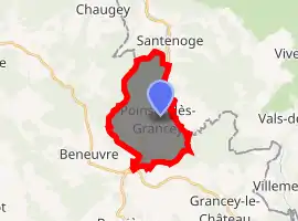
| |
 Poinson-lès-Grancey  Poinson-lès-Grancey | |
| Coordinates: 47°42′30″N 4°59′11″E | |
| Country | France |
| Region | Grand Est |
| Department | Haute-Marne |
| Arrondissement | Langres |
| Canton | Villegusien-le-Lac |
| Intercommunality | Auberive Vingeanne et Montsaugeonnais |
| Government | |
| • Mayor (2020–2026) | Jacques Boiget |
| Area 1 | 11.68 km2 (4.51 sq mi) |
| Population (2017-01-01)[1] | 45 |
| • Density | 3.9/km2 (10.0/sq mi) |
| Time zone | UTC+01:00 (CET) |
| • Summer (DST) | UTC+02:00 (CEST) |
| INSEE/Postal code | 52395 /52160 |
| Elevation | 369–489 m (1,211–1,604 ft) (avg. 433 m or 1,421 ft) |
| 1 French Land Register data, which excludes lakes, ponds, glaciers > 1 km2 (0.386 sq mi or 247 acres) and river estuaries. | |
Geography
The Ource flows northeastward through the southern part of the commune, then forms its north-eastern border.
References
- "Populations légales 2017". INSEE. Retrieved 6 January 2020.
| Wikimedia Commons has media related to Poinson-lès-Grancey. |
This article is issued from Wikipedia. The text is licensed under Creative Commons - Attribution - Sharealike. Additional terms may apply for the media files.