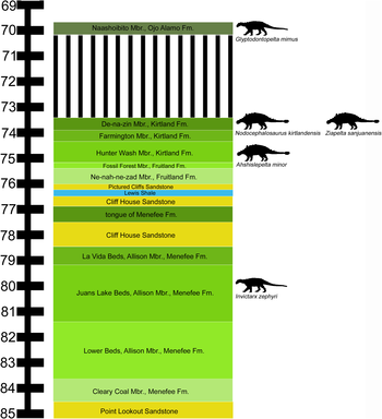
Point Lookout Sandstone
The Point Lookout Sandstone is a Cretaceous bedrock formation occurring in New Mexico and Colorado.
| Point Lookout Sandstone Stratigraphic range: Upper Cretaceous | |
|---|---|
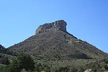 Point Lookout, Mesa Verde National Park | |
| Type | Formation |
| Unit of | Mesaverde Group |
| Sub-units | Hosta Tongue |
| Underlies | Menefee Formation |
| Overlies | Crevasse Canyon Formation |
| Thickness | 300 ft (91 m) |
| Lithology | |
| Primary | Sandstone |
| Other | Shale |
| Location | |
| Coordinates | 37.3158126°N 108.4188265°W |
| Region | Paradox Basin, San Juan Basin |
| Country | United States |
| Type section | |
| Named for | Point Lookout |
| Named by | A. J. Collier |
| Year defined | 1919 |

Description
The formation consists of two informal members. The lower is a sequence of thinly bedded sandstone and shale,[1] while the upper is a massive medium- to fine-grained cross-bedded sandstone, light gray to buff in color, that is a conspicuous cliff-forming unit.[1][2] Maximum thickness is 131 meters (430 feet).[1]
The lower contact is placed at the first thin sandstone bed above the shale of the Mancos Shale. The formation is overlain by the Menefee Formation.[1]
The Point Lookout Sandstone was deposited in the Cretaceous Interior Seaway, as part of a regressive sequence as the seaway was receding. It is transitional between the marine environment of the underlying Mancos and the coastal plain environment of the overlying Menefee Formation.
Fossils
Dinosaur remains are among the fossils that have been recovered from the formation, although none have yet been referred to a specific genus.[3]
The ammonite Clioscaphites vermiformis was identified in the formation.[4]
History of investigation
The sandstone was first described by A. J. Collier for exposures in cliffs at Point Lookout, in Mesa Verde National Park, Montezuma County, Colorado, in the Paradox Basin,[5] and later described by Allen and Balk in 1954 as part of the Mesaverde Group in the San Juan Basin in New Mexico.[6]
See also
- List of dinosaur-bearing rock formations
Footnotes
- Lucas and Heckert 2005
- Cather 2010
- Weishampel et al. 2004
- Tschudy 1976
- Collier 1919
- Allen and Balk 1954
References
- Allen, J.E.; Balk, Robert (1954). "Mineral Resources of Fort Defiance and Tohatchi quadrangles, Arizona and New Mexico". New Mexico Bureau of Mines and Mineral Resources Bulletin. 36.
- Cather, Steven (2010). "Preliminary geologic map of the San Lucas Dam quadrangle, McKinley County, New Mexico". New Mexico Bureau of Geology and Mineral Resources, Open-File Geologic Map. OF-GM 212. Retrieved 4 June 2020.
- Collier, A.J. (1919). "Coal south of Mancos, Montezuma County, Colorado". Contributions to economic geology, 1918; Part 2, Mineral fuels: U.S. Geological Survey Bulletin. 691-K: K293–K310.
- Lucas, Spencer G.; Heckert, Andrew B. (2005). "Mesozoic stratigraphy at Durango, Colorado" (PDF). New Mexico Geological Society Field Conference Series. 56. Retrieved 8 June 2020.
- Tschudy, R.H. (1976). "Palynology of Crevasse Canyon and Menefee Formation of San Juan basin, New Mexico". In Beaumont, E.C.; Shomaker, J.W.; Stone, W.J. (eds.). Guidebook to coal geology of northwest New Mexico: New Mexico Bureau of Mines and Mineral Resources Circular. 154. pp. 48–55.
- Weishampel, David B.; Dodson, Peter; Osmólska, Halszka. The Dinosauria (2nd ed.). Berkeley: University of California Press. ISBN 0-520-24209-2.