Mancos Shale
The Mancos Shale or Mancos Group is a Late Cretaceous (Upper Cretaceous) geologic formation of the Western United States.
| Mancos Shale Stratigraphic range: Mid Albian-Campanian ~110–80 Ma | |
|---|---|
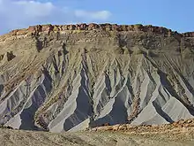 Mancos Shale badlands in Capitol Reef National Park, southern Utah. | |
| Type | Geologic formation |
| Sub-units | See text |
| Underlies | Mesaverde Formation |
| Overlies | Dakota Group |
| Lithology | |
| Primary | Shale |
| Location | |
| Coordinates | 37.3525426°N 108.2969254°W |
| Region | Arizona, Colorado, New Mexico, Utah, Wyoming |
| Country | |
| Extent | Basin and Range, Colorado Plateau & San Juan Mountains Provinces |
| Type section | |
| Named for | Mancos, Colorado |
The Mancos Shale was first described by Cross and Purington in 1899[1] and was named for exposures near the town of Mancos, Colorado.
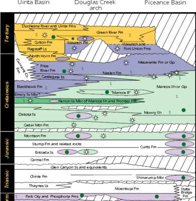
Geology
It is dominated by mudrock that accumulated in offshore and marine environments of the Cretaceous North American Inland Sea. The Mancos was deposited during the Cenomanian (locally Albian) through Campanian ages, approximately from 95 Ma to 80 Ma.
Stratigraphically the Mancos Shale fills the interval between the Dakota Group and the Mesaverde Formation Group.[2]
The Mancos Shale rests conformably on the Dakota and in its upper part grades into and intertongues with the Mesaverde Group. The shale tongues typically have sharp basal contacts and gradational upper contacts.
The classification broadly correspondences with the Colorado Group classification of the Great Plains region; as such, various units of the Colorado Group are recognized within the Mancos.[3]
Occurrences
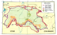
The Mancos occurs in the Basin and Range Province, the Colorado Plateau Province, and the San Juan Mountains Province.
Structural basins
It also occurs in the following structural basins:[4]
|
|
Subunits
The Mancos occurs with the following subunit names (listed alphabetically):[4] (bold: principle reference section at the type location)[6][7]
|
|
|
See also
References
- Cross, W. and Purington, C. W. (1899) "Description of the Telluride quadrangle, Colorado" United States Geological Survey Atlas, Folio 57
- Weimar, R.J. (1960). "Upper Cretaceous Stratigraphy, Rocky Mountain Area". AAPG Bulletin. 44: 1-20. doi:10.1306/0BDA5F6F-16BD-11D7-8645000102C1865D.
- Charlse H. Rankin. "Stratigraphy of the Colorado Group, Upper Cretaceous, in Northern New Mexico" (PDF). New Mexico Bureau of Mines and Mineral Resources Bulletins. New Mexico School of Mines (20): 5. Retrieved 2018-08-13.
...that all divisions of the Colorado group (Mancos shale) as described in southern Colorado, except the Fort Hays limestone and the Apishapa shale, can be recognized in northern New Mexico.
- "Colorado River Basin Stratigraphy: Mancos Shale" United States Geological Survey
- New Mexico Geological Association.edu: "SURFACE and SUBSURFACE STRATIGRAPHY of the BURRO CANYON FORMATION, DAKOTA SANDSTONE, and INTERTONGUED MANCOS SHALE of the CHAMA BASIN, NEW MEXICO"; 2005.
- R. Mark Leckie, James I. Kirkland, and William P. Elder (1997). "Stratigraphic Framework and Correlation of a Principle Reference Section of the Mancos Shale (Upper Cretaceous), Mesa Verde, Colorado" (PDF). 48th Annual NMGS Fall Field Conference Guidebook. Mesozoic Geology and Paleontology of the Four Corners Area: 288. Retrieved 2018-08-04.CS1 maint: uses authors parameter (link)
- Russell K. Lewis, Stratigraphy and depositional environments of the Late Cretaceous (Late Turonian) Codell sandstone and Juana Lopez members of the Carlile shale, southeast Colorado (PDF), 2013 - Mines Theses & Dissertations, retrieved 2018-08-14
