Ponca, Nebraska
Ponca is a city and county seat of Dixon County, Nebraska, United States.[10] The population was 961 at the 2010 census.[11]
Ponca, Nebraska | |
|---|---|
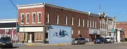 The downtown Ponca Historic District is listed in the National Register of Historic Places.[2] | |
| Motto(s): "A Great Place To Visit, A Better Place To Live"[3] | |
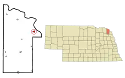 Location within Dixon County (left) and Nebraska (right) | |
| Coordinates: 42°33′50″N 96°42′38″W | |
| Country | United States |
| State | Nebraska |
| County | Dixon |
| Established | 1856[3] |
| Incorporated | 1871[4] |
| Area | |
| • Total | 0.76 sq mi (1.96 km2) |
| • Land | 0.76 sq mi (1.96 km2) |
| • Water | 0.00 sq mi (0.00 km2) |
| Elevation | 1,148 ft (350 m) |
| Population | |
| • Total | 961 |
| • Estimate (2019)[7] | 912 |
| • Density | 1,203.17/sq mi (464.76/km2) |
| Time zone | UTC-6 (Central (CST)) |
| • Summer (DST) | UTC-5 (CDT) |
| ZIP code | 68770 |
| Area code(s) | 402 |
| FIPS code | 31-39695[8] |
| GNIS feature ID | 0832300[9] |
| Website | www |
History
Ponca was established in 1856 and is Nebraska's fourth oldest town.[3] It was named for the Ponca Indian tribe native to the region.[12][13] Ponca was incorporated as a village in 1871.[4]
Ponca experienced growth when the Covington, Columbus and Black Hills Railroad was extended to it in 1876.[14]
Ponca also hosts one of the oldest rodeos in Nebraska, called the “Days of ‘56” to honor the founding members of the community. The rodeo is held at the town's rodeo grounds during the last full weekend in June. The 2018 rodeo marked the 50th anniversary of the event.[15]
Geography
Ponca is located at 42°33′50″N 96°42′38″W (42.563964, -96.710563).[16]
According to the United States Census Bureau, the city has a total area of 0.73 square miles (1.89 km2), all land.[17]
Demographics
| Historical population | |||
|---|---|---|---|
| Census | Pop. | %± | |
| 1880 | 594 | — | |
| 1890 | 1,009 | 69.9% | |
| 1900 | 1,043 | 3.4% | |
| 1910 | 1,000 | −4.1% | |
| 1920 | 1,014 | 1.4% | |
| 1930 | 920 | −9.3% | |
| 1940 | 1,003 | 9.0% | |
| 1950 | 893 | −11.0% | |
| 1960 | 924 | 3.5% | |
| 1970 | 984 | 6.5% | |
| 1980 | 1,057 | 7.4% | |
| 1990 | 877 | −17.0% | |
| 2000 | 1,062 | 21.1% | |
| 2010 | 961 | −9.5% | |
| 2019 (est.) | 912 | [7] | −5.1% |
| U.S. Decennial Census[18] | |||
Ponca is part of the Sioux City, IA–NE–SD Metropolitan Statistical Area.
2010 census
At the 2010 census there were 961 people in 403 households, including 256 families, in the city. The population density was 1,316.4 inhabitants per square mile (508.3/km2). There were 428 housing units at an average density of 586.3 per square mile (226.4/km2). The racial makeup of the city was 97.8% White, 0.4% African American, 0.2% Native American, 0.1% from other races, and 1.5% from two or more races. Hispanic or Latino of any race were 1.8%.[6]
Of the 403 households 30.0% had children under the age of 18 living with them, 51.9% were married couples living together, 8.4% had a female householder with no husband present, 3.2% had a male householder with no wife present, and 36.5% were non-families. 32.8% of households were one person and 19.1% were one person aged 65 or older. The average household size was 2.28 and the average family size was 2.88.
The median age was 43.9 years. 24.3% of residents were under the age of 18; 6.2% were between the ages of 18 and 24; 21% were from 25 to 44; 27.1% were from 45 to 64; and 21.5% were 65 or older. The gender makeup of the city was 49.1% male and 50.9% female.
2000 census
At the 2000 census there were 1,062 people in 403 households, including 286 families, in the city. The population density was 1,508.2 people per square mile (585.8/km2). There were 425 housing units at an average density of 603.5 per square mile (234.4/km2). The racial makeup of the city was 96.89% White, 0.56% Native American, 0.94% from other races, and 1.60% from two or more races. Hispanic or Latino of any race were 2.64%.[8]
Of the 403 households 35.5% had children under the age of 18 living with them, 57.1% were married couples living together, 11.2% had a female householder with no husband present, and 28.8% were non-families. 25.6% of households were one person and 13.4% were one person aged 65 or older. The average household size was 2.51 and the average family size was 3.00.
The age distribution was 26.6% under the age of 18, 7.9% from 18 to 24, 25.1% from 25 to 44, 20.6% from 45 to 64, and 19.8% 65 or older. The median age was 39 years. For every 100 females, there were 92.0 males. For every 100 females age 18 and over, there were 83.5 males.
The median household income was $31,750, and the median family income was $41,250. Males had a median income of $28,472 versus $21,681 for females. The per capita income for the city was $15,782. About 7.0% of families and 8.6% of the population were below the poverty line, including 10.5% of those under age 18 and 12.1% of those age 65 or over.
Parks and recreation
Ponca State Park is two miles north of the city. The park is located on the heavily forested high bluffs and steep hills along the Nebraska banks of the Missouri River. Ponca State Park is the eastern terminus for float trips through the federally designated National Wild and Scenic River.[3]
Notable people
- Tommy Atkins, Baseball player[19]
- Pug Bennett, Baseball player[20]
References
- "Nebraska National Register Sites in Dixon County". Nebraska State Historical Society. Retrieved 2010-11-26.
- "Nebraska National Register Sites in Dixon County". Nebraska State Historical Society. Retrieved 2010-11-26.
- "Ponca Nebraska". Ponca Nebraska. Retrieved October 19, 2012.
- "Ponca Nebraska". City-Data.com. Retrieved October 19, 2012.
- "2019 U.S. Gazetteer Files". United States Census Bureau. Retrieved July 26, 2020.
- "U.S. Census website". United States Census Bureau. Retrieved 2012-06-24.
- "Population and Housing Unit Estimates". United States Census Bureau. May 24, 2020. Retrieved May 27, 2020.
- "U.S. Census website". United States Census Bureau. Retrieved 2008-01-31.
- "US Board on Geographic Names". United States Geological Survey. 2007-10-25. Retrieved 2008-01-31.
- "Find a County". National Association of Counties. Retrieved 2011-06-07.
- http://www.yankton.net/articles/2011/03/03/community/doc4d6f181b374f9967268554.txt
- "Profile for Ponca, Nebraska, NE". ePodunk. Archived from the original on August 29, 2016. Retrieved October 19, 2012.
- Chicago and North Western Railway Company (1908). A History of the Origin of the Place Names Connected with the Chicago & North Western and Chicago, St. Paul, Minneapolis & Omaha Railways. p. 160.
- "Ponca, Dixon County". Center for Advanced Land Management Information Technologies. University of Nebraska. Retrieved 4 August 2014.
- http://www.daysof56.com
- "US Gazetteer files: 2010, 2000, and 1990". United States Census Bureau. 2011-02-12. Retrieved 2011-04-23.
- "US Gazetteer files 2010". United States Census Bureau. Archived from the original on 2012-01-25. Retrieved 2012-06-24.
- "Census of Population and Housing". Census.gov. Retrieved June 4, 2015.
- "Tommy Atkins Stats". Baseball Almanac. Retrieved October 19, 2012.
- "Pug Bennett Stats". Baseball Almanac. Retrieved October 19, 2012.
External links
| Wikimedia Commons has media related to Ponca, Nebraska. |
Municipalities and communities of Dixon County, Nebraska, United States | ||
|---|---|---|
| Cities | Map of Nebraska highlighting Dixon County | |
| Villages | ||
| Townships | ||
| Indian reservations | ||
| Unincorporated community | ||
| Ghost town | ||
| Footnotes | ‡This populated place also has portions in an adjacent county or counties | |
| ||
