Dixon County, Nebraska
Dixon County is a county in the U.S. state of Nebraska. As of the 2010 United States Census, the population was 6,000.[1] Its county seat is Ponca.[2] The county was created in 1856 and attached to Dakota County. It was organized in 1858.[3][4]
Dixon County | |
|---|---|
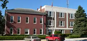 Dixon County courthouse in Ponca | |
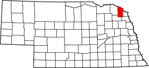 Location within the U.S. state of Nebraska | |
 Nebraska's location within the U.S. | |
| Coordinates: 42°30′N 96°52′W | |
| Country | |
| State | |
| Founded | 1856 (authorized) 1858 (organized) |
| Seat | Ponca |
| Largest city | Wakefield |
| Area | |
| • Total | 483 sq mi (1,250 km2) |
| • Land | 476 sq mi (1,230 km2) |
| • Water | 6.7 sq mi (17 km2) 1.4%% |
| Population | |
| • Estimate (2018) | 5,709 |
| • Density | 12.1/sq mi (4.7/km2) |
| Time zone | UTC−6 (Central) |
| • Summer (DST) | UTC−5 (CDT) |
| Congressional district | 3rd |
| Website | [<span%20class="url"> |
Dixon County is part of the Sioux City, IA–NE–SD Metropolitan Statistical Area.
In the Nebraska license plate system, Dixon County is represented by the prefix 35 (it had the 35th-largest number of vehicles registered in the county when the license plate system was established in 1922).
Geography
Dixon County lies at the northeast edge of the state. Its northern boundary line abuts the southern boundary line of the state of South Dakota, across the Missouri River. According to the US Census Bureau, the county has an area of 483 square miles (1,250 km2), of which 476 square miles (1,230 km2) is land and 6.7 square miles (17 km2) (1.4%) is water.[5]
Major highways
National protected area
State protected area
- Buckskin Hills State Wildlife Management Area[6]
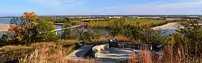
- Ponca State Park
- Tarbox Hollow Living Prairie[7]
Adjacent counties
- Union County, South Dakota - northeast
- Dakota County - east
- Thurston County - southeast
- Wayne County - southwest
- Cedar County - west
- Clay County, South Dakota - northwest
Demographics
| Historical population | |||
|---|---|---|---|
| Census | Pop. | %± | |
| 1860 | 274 | — | |
| 1870 | 1,345 | 390.9% | |
| 1880 | 4,177 | 210.6% | |
| 1890 | 8,084 | 93.5% | |
| 1900 | 10,535 | 30.3% | |
| 1910 | 11,477 | 8.9% | |
| 1920 | 11,815 | 2.9% | |
| 1930 | 11,586 | −1.9% | |
| 1940 | 10,413 | −10.1% | |
| 1950 | 9,129 | −12.3% | |
| 1960 | 8,106 | −11.2% | |
| 1970 | 7,453 | −8.1% | |
| 1980 | 7,137 | −4.2% | |
| 1990 | 6,143 | −13.9% | |
| 2000 | 6,339 | 3.2% | |
| 2010 | 6,000 | −5.3% | |
| 2018 (est.) | 5,709 | [10] | −4.8% |
| US Decennial Census[11] 1790-1960[12] 1900-1990[13] 1990-2000[14] 2010-2013[1] | |||
As of the 2000 United States Census,[15] there were 6,339 people, 2,413 households, and 1,705 families in the county. The population density was 13 people per square mile (5/km2). There were 2,673 housing units at an average density of 6 per square mile (2/km2). The racial makeup of the county was 94.64% White, 0.03% Black or African American, 0.49% Native American, 0.27% Asian, 3.79% from other races, and 0.79% from two or more races. 5.49% of the population were Hispanic or Latino of any race. 45.5% were of German, 10.4% Irish, 8.5% Swedish, 5.9% American, 5.9% Norwegian and 5.1% English.
There were 2,413 households, out of which 33.30% had children under the age of 18 living with them, 61.50% were married couples living together, 6.50% had a female householder with no husband present, and 29.30% were non-families. 25.90% of all households were made up of individuals, and 14.40% had someone living alone who was 65 years of age or older. The average household size was 2.58 and the average family size was 3.12.
The county population contained 27.50% under the age of 18, 7.10% from 18 to 24, 24.90% from 25 to 44, 22.40% from 45 to 64, and 18.20% who were 65 years of age or older. The median age was 39 years. For every 100 females, there were 98.50 males. For every 100 females age 18 and over, there were 94.50 males.
The median income for a household in the county was $34,201, and the median income for a family was $41,122. Males had a median income of $27,784 versus $20,573 for females. The per capita income for the county was $15,350. About 7.50% of families and 10.00% of the population were below the poverty line, including 12.40% of those under age 18 and 9.00% of those age 65 or over.
Communities
Unincorporated communities
Politics
Dixon County voters have been reliably Republican for decades. In only one national election since 1936 has the county selected the Democratic Party candidate, and that was the election of 1964, during Lyndon B. Johnson's landslide victory. However, he narrowly won the county then.
| Year | Republican | Democratic | Third Parties |
|---|---|---|---|
| 2016 | 73.4% 2,041 | 20.0% 556 | 6.7% 185 |
| 2012 | 65.0% 1,745 | 32.4% 870 | 2.6% 71 |
| 2008 | 63.9% 1,785 | 33.9% 946 | 2.3% 63 |
| 2004 | 67.4% 2,028 | 31.2% 938 | 1.4% 43 |
| 2000 | 65.7% 1,834 | 29.4% 820 | 4.9% 138 |
| 1996 | 52.0% 1,478 | 32.7% 931 | 15.3% 436 |
| 1992 | 48.6% 1,484 | 27.2% 830 | 24.2% 740 |
| 1988 | 60.5% 1,802 | 39.2% 1,166 | 0.3% 9 |
| 1984 | 68.1% 2,155 | 31.2% 986 | 0.7% 23 |
| 1980 | 68.8% 2,328 | 24.3% 822 | 6.9% 235 |
| 1976 | 59.4% 1,981 | 38.5% 1,286 | 2.1% 71 |
| 1972 | 71.0% 2,299 | 29.0% 941 | |
| 1968 | 65.7% 2,051 | 28.5% 890 | 5.9% 183 |
| 1964 | 49.1% 1,845 | 50.9% 1,912 | |
| 1960 | 66.2% 2,713 | 33.8% 1,384 | |
| 1956 | 59.1% 2,493 | 40.9% 1,726 | |
| 1952 | 70.4% 2,977 | 29.6% 1,249 | |
| 1948 | 52.4% 1,899 | 47.6% 1,722 | |
| 1944 | 62.0% 2,382 | 38.1% 1,463 | |
| 1940 | 61.4% 3,038 | 38.6% 1,912 | |
| 1936 | 43.3% 2,108 | 54.2% 2,640 | 2.5% 122 |
| 1932 | 34.8% 1,620 | 63.5% 2,953 | 1.7% 80 |
| 1928 | 64.8% 2,982 | 34.9% 1,607 | 0.3% 12 |
| 1924 | 51.0% 2,153 | 25.8% 1,090 | 23.2% 980 |
| 1920 | 71.4% 2,435 | 26.7% 911 | 1.9% 63 |
| 1916 | 46.2% 1,208 | 51.6% 1,350 | 2.2% 57 |
| 1912 | 24.0% 582 | 34.0% 823 | 42.0% 1,016 |
| 1908 | 51.7% 1,257 | 45.2% 1,100 | 3.1% 75 |
| 1904 | 64.8% 1,524 | 24.3% 571 | 10.9% 257 |
| 1900 | 52.5% 1,285 | 44.9% 1,101 | 2.6% 64 |
References
- "State & County QuickFacts". US Census Bureau. Archived from the original on June 7, 2011. Retrieved September 19, 2013.
- "Find a County". National Association of Counties. Archived from the original on 31 May 2011. Retrieved 7 June 2011.
- "Nebraska Historic Buildings Survey Reconnaissance Survey Final Report of Dixon and Dakota Counties, Nebraska" (PDF). Nebraska State Historical Society. June 1, 1987. Retrieved December 18, 2014.
- Andreas, A. T. (1882). "Andreas' History of the State of Nebraska". The Kansas Collection. Archived from the original on 2003-05-08. Retrieved December 18, 2014.
- "2010 Census Gazetteer Files". US Census Bureau. August 22, 2012. Archived from the original on November 13, 2013. Retrieved December 6, 2014.
- Buckskin Hills State Wildlife Management Area, Newcastle NE Google Maps (accessed 19 January 2019)
- Tarbox Hollow Living Prairie, Dixon NE Google Maps (accessed 19 January 2019)
- "Archived copy". Archived from the original on 4 July 2008. Retrieved 15 March 2008.CS1 maint: archived copy as title (link)
- Chicago and North Western Railway Company (1908). A History of the Origin of the Place Names Connected with the Chicago & North Western and Chicago, St. Paul, Minneapolis & Omaha Railways. p. 160.
- "Population and Housing Unit Estimates". Retrieved December 28, 2019.
- "US Decennial Census". US Census Bureau. Retrieved December 6, 2014.
- "Historical Census Browser". University of Virginia Library. Retrieved December 6, 2014.
- "Population of Counties by Decennial Census: 1900 to 1990". US Census Bureau. Retrieved December 6, 2014.
- "Census 2000 PHC-T-4. Ranking Tables for Counties: 1990 and 2000" (PDF). US Census Bureau. Retrieved December 6, 2014.
- "U.S. Census website". US Census Bureau. Retrieved 31 January 2008.
- Election Results
Places adjacent to Dixon County, Nebraska | ||||||||||
|---|---|---|---|---|---|---|---|---|---|---|
| ||||||||||
Municipalities and communities of Dixon County, Nebraska, United States | ||
|---|---|---|
| Cities | Map of Nebraska highlighting Dixon County | |
| Villages | ||
| Townships | ||
| Indian reservations | ||
| Unincorporated community | ||
| Ghost town | ||
| Footnotes | ‡This populated place also has portions in an adjacent county or counties | |
| ||

| Authority control |
|---|