Pondosa, Oregon
Pondosa is an unincorporated community and ghost town[1] in Union County, Oregon, United States. Pondosa has an elevation of 3261 feet (994 meters).[2]
Pondosa, Oregon | |
|---|---|
 Pondosa, Oregon  Pondosa, Oregon | |
| Coordinates: 45.008°N 117.643°W | |
| Country | United States |
| State | Oregon |
| County | Union |
| Time zone | UTC-8 (Pacific (PST)) |
| • Summer (DST) | UTC-7 (PDT) |
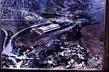
The town came into being in 1927, when the four Stoddard brothers of La Grande bought land in the area.[3] They moved the sawmill operations of the Grande Ronde Lumber Company in nearby Perry to the site.[3] The town was named after the Ponderosa Pines that dotted the area.[3] A post office was established in 1927.[3] In 1931, Truman Collins of The Collins Companies of Portland bought the mill.[4] The mill was sold again in 1956, this time to Boise Cascade, which made plans to shut down the mill.[3] This caused the decline of the town, which had over 500 inhabitants at the time.[3] The post office was discontinued[3] following a severe fire that damaged the majority of the town on June 20, 1959.[1]
References
- Bebout, Bill (June 22, 1959). "Ghost Town Of Pondosa Left In Charred Ruins By Flames". La Grande Observer. La Grande, Oregon. p. 1 – via Newspapers.com.
- "Pondosa". Geographic Names Information System. United States Geological Survey. Retrieved February 25, 2010.
- Barklow, Irene (1987). From Trails to Rails: The Post Offices, Stage Stops and Wagon Roads of Union County. Enterprise, Oregon: Enchantments Publishing of Oregon. pp. 224–227. ISBN 0-9618185-0-6.
- "A History of The Collins Companies". The Collins Companies. 2005. Retrieved February 25, 2010.
Municipalities and communities of Union County, Oregon, United States | ||
|---|---|---|
| Cities | 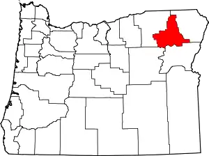 Map of Oregon highlighting Union County | |
| Unincorporated communities | ||
| Indian reservation | ||
| Ghost town | ||
| ||
On April 15, 1959, the Oregonian news paper published an article explaining how researchers determined Pondosa, Oregon the Geographical center of the 50 United States. W.O. and B.J. Holmes, president and vice president of Research Publications, Inc, San Carlos, California explained their designation of the ghost town of Pondosa as the closest geographical center point which is actually 4 miles from the town to the North East. They wrote: "This point is exactly 2,478 miles and 2 inches from the eastern boundary- parallel of longitude which passed through Quoddy Pt., Maine; and exactly the same distance from the western boundary - the parallel of longitude which passes through Cape Prince of Wales, westernmost point of land in the new U.S. not counting the pinpoint island of the Aleutian chain. The Pondosa point is exactly equidistant between parallel of latitude that passes through Point Barrow, our northernmost shore, and the parallel which passes through Pt. Kalae, the southernmost tip of land in the new United States. Incidentally, Pondosa also proved to be 3,107 miles and 3,046 feet from the equator and 3,107 miles, 1,552 feet from the North Pole, almost equidistant between the equator and the North Pole. It is 2,750 miles from Honolulu; 2,250 miles from New York; 2,475 miles from Miami; and 228 miles to Portland." "No other place can claim to be so centrally located," said the Holmes brothers, who manufacture and distribute satellite trackers declared during a visit to Portland Monday en route to a virtual aids conference in Seattle. Further more, the article states that "the Holmes brothers suggest that the point be marked with a compass rose showing its exact distance from all major points that point the new U.S. boundaries and signage to show the geographical center." Also, the in the article the researchers state that other methods used to find the geographic center fail to be accurate as it puts the center in Canada or Mid West.
In 1959, the National Geographic Society came out from LaGrande, OR and erected a sign near the town of Pondosa. (When they came out, snow was on the Catherine Creek pass that prevented the trek to Pondosa, so it was originally erected on the LaGrande side of Catherine Creek pass with a notation saying that the center point was 7 miles further.)
Today, Pondosa has a replica of the original sign posted at the location of the old town. The old mill's boarding hotel, now a country store, remains open for travelers and guests. Visitors can wander around, look at old pictures and hear old stories of when the Pondosa town was booming. There is an annual Pondosa picnic for past residents and families of the ghost town. They meet, eat and share old stories every August. For more information on Pondosa, you may look it up on the internet under: Pondosa, Oregon. The Geographic Center of the 50 United States.