Port Waikato
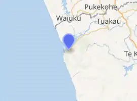
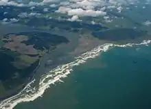
Port Waikato is on the south bank of the Waikato River at its outflow into the Tasman Sea, in northern New Zealand.[1]
Port Waikato | |
|---|---|
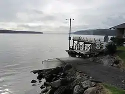 Wharf overlooking the Waikato River | |
| |
| Country | New Zealand |
| Region | Waikato |
| District | Waikato |
| Population (2018) | |
| • Total | 528 |
Port Waikato is a well-known surfing and whitebaiting destination and a popular holiday spot. Fish can be caught off the rocks and surf beach, and off the sand dunes that border the river mouth. Flounder and mullet are also plentiful using drag nets. Port Waikato is a location where sedimentary rock formations of 65–85 million years' antiquity are found,[2] and a Jurassic-period dinosaur fossil was found there.[3] Weathertop footage from the Lord of the Rings was filmed in limestone outcrops just south of the town.
The Port has a Wharf Store, established 1893, a take-away shop, café, campground, library, community hall, fire station, surf lifesaving club, yachting club and an active fishing club.[1] A school camp was established near the town in the 1920s, which boasts a well-formed BMX track. Port Waikato also serves as a popular wedding destination.[4]
History
Port Waikato was an important port during the New Zealand Wars of the 19th century.[5] It was the first of the colonial settlements to be constructed after the wars, being started in 1863. It had until then been called Putataka,[6] but soon the present name was in general use.[5] The Māori name remains for the 354 m (1,161 ft) hill above the town.[7]
For many years Port Waikato was the transhipment point between ships of the Northern Steamship Co and the river steamers of the Waikato Shipping Co, run by Caesar Roose.[8] The frequency increased to twice a week in 1924.[9] At the same time a Cambridge to Port Waikato excursion was being run two or three times a year, taking 12 to 14 hours downstream and a few hours longer upstream.[10] Now the only public transport is a morning and afternoon bus from Pukekohe on Thursdays.[11]
Demographics
| Year | Pop. | ±% p.a. |
|---|---|---|
| 2006 | 729 | — |
| 2013 | 732 | +0.06% |
| 2018 | 783 | +1.36% |
| Source: [12] | ||
The statistical area of Port Waikato-Waikaretu, which at 210 square kilometres is much larger than this village and includes Waikaretu, had a population of 783 at the 2018 New Zealand census, an increase of 51 people (7.0%) since the 2013 census, and an increase of 54 people (7.4%) since the 2006 census. There were 330 households. There were 384 males and 396 females, giving a sex ratio of 0.97 males per female. The median age was 46.3 years, with 144 people (18.4%) aged under 15 years, 120 (15.3%) aged 15 to 29, 384 (49.0%) aged 30 to 64, and 132 (16.9%) aged 65 or older.
Ethnicities were 69.3% European/Pākehā, 39.8% Māori, 3.8% Pacific peoples, 1.9% Asian, and 2.3% other ethnicities (totals add to more than 100% since people could identify with multiple ethnicities).
The proportion of people born overseas was 9.2%, compared with 27.1% nationally.
Although some people objected to giving their religion, 58.6% had no religion, 29.1% were Christian, 0.0% were Hindu, 0.0% were Muslim, 0.0% were Buddhist and 3.8% had other religions.
Of those at least 15 years old, 87 (13.6%) people had a bachelor or higher degree, and 186 (29.1%) people had no formal qualifications. The median income was $27,800. The employment status of those at least 15 was that 309 (48.4%) people were employed full-time, 78 (12.2%) were part-time, and 27 (4.2%) were unemployed.[12]
Port Waikato itself had a population of 528 in the 2018 census, an increase of 57 people since the 2013 census. There were 264 males, and 264 females.[13]
Marae
The local Ōraeroa Marae and its Whareroa meeting house is meeting place for the Waikato Tainui hapū of Ngāti Tāhinga and Ngāti Tiipa.[14][15]
Education
Te Kura Kaupapa Māori o Te Puaha o Waikato is a co-educational state Māori immersion primary school,[16] with a roll of 40 as of March 2020.[17]
See also
| Wikimedia Commons has media related to Port Waikato. |
- Port Waikato electorate
Neighbouring areas | ||||||||||
|---|---|---|---|---|---|---|---|---|---|---|
| ||||||||||
References
- "Port Waikato". www.waikatodistrict.govt.nz. Retrieved 2016-06-06.
- "Kiwi fossil hunter's very big find". The New Zealand Herald. 24 June 2008. Retrieved 24 February 2019.
- "Dinosaur hunter: Joan Wiffen". Stuff.co.nz. 31 January 2009. Retrieved 24 February 2019.
- "Port Waikato School Camp". Port Waikato School Camp. Retrieved 2015-07-10.
- "Port Waikato". New Zealand Herald. 1863-12-09. p. 3. Retrieved 2016-06-05.
- "Waikato". Otago Daily Times. 1864-01-19. p. 6. Retrieved 2016-06-05.
- "Putataka, Waikato - NZ Topo Map". NZ Topo Map. Retrieved 2016-06-05.
- "Page 1 Advertisements Column 4". Waikato Times. 1916-09-27. p. 1. Retrieved 2016-06-06.
- "Waikato River Trade". New Zealand Herald. 1926-03-31. p. 12. Retrieved 2016-06-06.
- Scenic River Trip - New Zealand Herald, Volume LXII, Issue 18947, 19 February 1925, Page 9
- "Southern Bus Timetable" (PDF). AT. 26 August 2018.
- "Statistical area 1 dataset for 2018 Census". Statistics New Zealand. March 2020. Port Waikato-Waikaretu (170400). 2018 Census place summary: Port Waikato-Waikaretu
- "Age and sex by ethnic group (grouped total response), for census usually resident population counts, 2006, 2013, and 2018 Censuses (urban rural areas)". Statistics New Zealand. Retrieved 20 November 2020.
- "Te Kāhui Māngai directory". tkm.govt.nz. Te Puni Kōkiri.
- "Māori Maps". maorimaps.com. Te Potiki National Trust.
- Education Counts: Te Kura Kaupapa Māori o Te Puaha o Waikato
- "Education Review Office Report". ero.govt.nz. Education Review Office.
