Port of Kolkata
Port of Kolkata or Kolkata Port (KoPT) officially known as Syama Prasad Mookerjee Port Trust, is the only riverine major port of India[8] located in the city of Kolkata, West Bengal, around 203 kilometres (126 mi) from the sea.[9] It is the oldest operating port in India[10] and was constructed by the British East India Company.[11] Kolkata is a freshwater port with no variation in salinity.[12] The port has two distinct dock systems — Kolkata Docks at Kolkata and a deep water dock at Haldia Dock Complex, Haldia. In the 19th century, the Kolkata Port was the premier port in British India. After slavery was abolished in 1833, there was a high demand for labourers on sugar cane plantations in the British Empire. From 1838 to 1917, the British used this port to ship off over half a million Indians from all over India — mostly from the Hindi Belt (especially Bhojpur and Awadh) — and take them to places across the world, such as Mauritius, Fiji, South Africa, Trinidad and Tobago, Guyana, Suriname, and other Caribbean islands as indentured labourers. There are millions of Indo-Mauritians, Indo-Fijians, and Indo-Caribbean people in the world today.
| Syama Prasad Mookerjee Port Trust | |
|---|---|
| Location | |
| Country | |
| Location | Kolkata, West Bengal, India |
| Coordinates | 22°32′46″N 88°18′53″E |
| UN/LOCODE | INCCU[1] |
| Details | |
| Opened | 1870 |
| Operated by | Syama Prasad Mookerjee Port Trust |
| Owned by | Syama Prasad Mookerjee Port Trust, Ministry of Ports, Shipping and Waterways, Government of India |
| Type of harbor | Coastal breakwater, riverine, large seaport |
| Size | 4,500 acres[2] |
| Available berths | 28 (Kolkata) 12 (Haldia) |
| Wharfs | 86 |
| Employees | 3,600 [2] |
| Official name | Syama Prasad Mukherjee Port |
| Main trades | Automobiles, motorcycles and general industrial cargo including iron ore, granite, coal, fertilizers, petroleum products, and containers Major exports: Iron ore, leather, cotton textiles Major imports: Wheat, raw cotton, machinery, iron & steel |
| Stacking area | 134722 sqm |
| Statistics | |
| Vessel arrivals | 3670 (2017-2018) [3][4] |
| Annual cargo tonnage | 63.71 million tonnes (2018-19) [3][4] |
| Annual container volume | 8,30,000 (2018-2019)[5]TEUs[6] |
| Passenger traffic | 20,396 (2016-17)[7] |
| Annual revenue | ₹1,242.23 crore (US$170 million) |
| Net income | ₹60 crore (US$8.4 million) (2018-2019)[2] |
| Website www | |
After independence, the port's importance decreased because of factors including the Partition of Bengal (1947), reduction in the size of the port hinterland, and economic stagnation in eastern India.
It has a vast hinterland comprising the entire North East of India including West Bengal, Bihar, Jharkhand, Uttar Pradesh, Madhya Pradesh, Assam, North East Hill States and two landlocked neighbouring countries namely, Nepal and Bhutan and also the Autonomous Region of Tibet (China). With the turn of the century, the volume of throughput has again started increasing steadily. As of March 2018, the port is capable of processing annually 650,000 containers, mostly from Nepal, Bhutan, and India's northeastern states.[11]
History
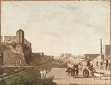
In the early 16th century, the Portuguese first used the present location of the port to anchor their ships, since they found the upper reaches of the Hooghly river, beyond Kolkata, unsafe for navigation. Job Charnock, an employee and administrator of the British East India Company, is believed to have founded a trading post at the site in 1690. Since the area was situated on the river with jungle on three sides, it was considered safe from enemy invasion. After the abolition of slavery in the British Empire in 1833, this port was used to ship lakhs of Indians as ‘indentured labourers’ to far-flung territories throughout the Empire.[13]
After slavery was abolished in 1833, there was a high demand for labourers on sugar cane plantations in the British Empire. From 1838 to 1917, the British used this port to ship off over half a million Indians from all over India — mostly from the Hindi Belt (especially Bhojpur and Awadh) — and take them to places across the world, such as Mauritius, Fiji, South Africa, Trinidad and Tobago, Guyana, Suriname, and other Caribbean islands as indentured labourers. There are millions of Indo-Mauritians, Indo-Fijians, and Indo-Caribbean people in the world today.
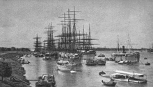
As Kolkata grew in size and importance, merchants in the city demanded the setting up of a port trust in 1863. The colonial government formed a River Trust in 1866, but it soon failed, and administration was again taken up by the government. Finally, in 1870, the Calcutta Port Act (Act V of 1870) was passed, creating the offices of Calcutta Port Commissioners. In 1869 and 1870, eight jetties were built on the Strand. A wet dock was set up at Khidirpur in 1892. The Khidirpur Dock II was completed in 1902. As cargo traffic at the port grew, so did the requirement of more kerosene, leading to the building of a petroleum wharf at Budge Budge in 1896. In 1925, the Garden Reach jetty was added to accommodate greater cargo traffic. A new dock, named King George's Dock, was commissioned in 1928 (it was renamed Netaji Subhash Dock in 1973).[13]
Though the port was conceived to be a commercial port and gateway of eastern India, the port played a very important role in the Second World War. It was bombed[14] twice by the Japanese forces. After independence, the Commissioners for the Port of Kolkata were responsible for the port till January 1975 when Major Port Trusts Act, 1963, came into force. The Port is now run by a Board of Trustees having representatives from the Government, Trade Bodies, various Port Users, Labour Unions and some nominated members. On 12 January 2020, the port was renamed to Syama Prasad Mookerjee Port by Prime Minister Narendra Modi on the occasion of 150 years of operation of Kolkata Port at Netaji Indoor Stadium.[15]
The port is part of the 21st Century Maritime Silk Road that runs from the Chinese coast via the Suez Canal to the Mediterranean, there to the Upper Adriatic region of Trieste with its rail connections to Central and Eastern Europe.[16][17][18]
Terminals
Dock systems
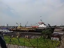
The Kolkata Port Trust (KoPT) manages two separate dock agglomerations, the Kolkata Dock System (KDS) and the Haldia Dock Complex (HDC).
Kolkata Dock System
It is situated on the left bank of the Hooghly River at about 203 km (126 mi) upstream from the sea. The pilotage station is at Gasper/ Saugor roads, 145 Kilometres to the south of the KDS (around 58 km from the sea). The system consists of:[19]
- Kidderpore Docks (K.P. Docks) : 18 Berths, 6 Buoys / Moorings and 3 Dry Docks
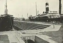
 Khidirpore Dock of Syama Prasad Mukherjee Port Trust
 - Netaji Subhas Docks (N.S. Docks): 10 Berths, 2 Buoys / Moorings and 2 Dry Docks
- Budge Budge River Moorings : 6 Petroleum Wharves
- Anchorages : Diamond Harbour, Saugor Road, Sandheads
Apart from this, there are around 80 major riverine jetties, and many minor jetties, and a large number of ship breaking berths.
Haldia Dock Complex
It is situated at around 60 kilometres (37 mi) away from the pilotage station. The complex consists of:
- Impounded Dock. System with 12 Berths
- 3 Oil Jetties in the River
- 3 Barge Jetties in the River for handling Oil carried by Barges.
- Haldia Anchorage for lash vessels.
All the docks are impounded dock systems with locks from river.
Dry Dock
KoPT has the largest dry dock facility in India . These dry docks cater to the diverse repair and maintenance needs of the vessels calling on the Eastern Ports of India. In addition, shipbuilding facilities are also available in these dry docks. All the dry docks are inside the impounded dock system. There are five dry docks of which three are in Kidderpore Dock and two are in Netaji Subhas Dock.[9]
| Dock | Dry Dock Number | Size |
|---|---|---|
| Netaji Subhas Dock | 1 | 172.21 metres (565.0 ft) x 22.86 metres (75.0 ft) |
| Netaji Subhas Dock | 2 | 172.21 metres (565.0 ft) x 22.86 metres (75.0 ft) |
| Kidderpore Dock | 1 | 160.02 metres (525.0 ft) x 19.5 metres (64 ft) |
| Kidderpore Dock | 2 | 142.95 metres (469.0 ft) x 19.5 metres (64 ft) |
| Kidderpore Dock | 3 | 102.1 metres (335 ft) x 14.63 metres (48.0 ft) |
There is a fully-fledged repair workshop including Diesel Engine Overhauling Unit, Structural Shop, Heavy and Light Machine Shop, Forging Shop, Electrical Shop and a Chain Testing/Repair Shop with 2500 KN capacity Tensile Compression Testing Machine to support various activities in the dry dock.
Pilotage
Due to the constraints of the river (like silting, sandbars etc.) no seagoing vessel above 200 GT is allowed to navigate without a qualified pilot of the Kolkata Port Trust. The total pilotage distance to KDS is 221 kilometres (137 mi), comprising 148 kilometres (92 mi) in river and 75 kilometres (47 mi) in sea, and for HDC is 121 kilometres (75 mi), comprising 46 kilometres (29 mi) in river and 75 kilometres (47 mi) in sea.
Lighthouse
- Sagar Lighthouse is situated at Middleton Point on the Sagar Island 1.5 kilometres (0.93 mi) inshore. It is visible from a distance of 28 kilometres (17 mi) in clear weather.[9]
- Dariapur Lighthouse is situated on the right bank of Hooghly River south of Rasulpur river and about 2.7 kilometres (1.7 mi) inshore. It is visible from a distance of 35 kilometres (22 mi) in clear weather.[9]
Light Vessels
- There are four unmanned light vessels to aid in navigation.
- U.G.L.F. located at
- L.G.L.F. located at
- Talent WK L.V. located at
- Eastern Channel L.V. located at
Automatic Tide Gauges
These are maintained at Tribeni, Garden Reach, Diamond Harbour and Haldia for round-the-clock recording of tidal data, which is used for the prediction of tides and preparation of tide tables by Survey of India.
Semaphores
These are maintained at Akra, Moyapur, Hooghly Point, Balari, Gangra and Sagar for displaying rises of tide for the convenience of various vessels navigating, dredging and surveying in the River Hooghly. The semaphores used to display the tide level at these localities on a mast by the position of the meter and decimeter arms which were manually rotated with the rise and fall of every decimeter of tidal level. However these semaphores are no longer functional and instead, tidal levels are broadcast over VHF radio every half an hour from all the above stations except at Balari.
River Marks and Buoys
A total of 500 (of which 140 are lighted) River Marks and Buoys are maintained by the KoPT. These are extremely useful in facilitating night navigation, pilotage and dredging. These lights are operated either by grid electricity, by battery or by dissolved Marine Acetylene Gas. There is also 1 boat buoy, 30 lighted buoys and 72 unlit buoys marking the navigational channel from Sandheads to Kolkata. It has one of the longest navigational channels in the world.
Differential Global Positioning System (Differential GPS)
In the wide estuary, position fixing with reference to shore objects to be viewed from the deck of a vessel, is very difficult. In 1983 KoPT introduced the Electronic Position Fixing System "Syledis" for position fixing of the vessels plying in the wide estuary of the Hooghly river. The shore-based Syledis Position Fixing System was functioning round the clock with the help of the Syledis Stations located at Haldia, Raichak, Dadanpatra Bar and Frazergunj. The system was effectively utilized for the purpose of hydrographic survey and dredging. KoPT has now replaced the Syledis Position Fixing System by Differential GPS (Differential Global Position Fixing System). This latest state-of the art technology provides improved location accuracy of up to 10 cm.
Satellite ports
Statistics
In the fiscal year 2013–14, Port of Kolkata handled 41.386 million metric tons (45.620 million short tons) of cargo. This is significantly less than 53.143 million metric tons (58.580 million short tons) of cargo it handled in 2005–06. However, the number of vessels handled at Kolkata Port during 2013–2014 was the highest among all Indian Major Ports. KoPT handled 17.1% of the total number of vessels, which worked at Indian Major Ports in 2011–2012; significant improvement over 2011-12 which was 16%. During the fiscal year 2011–2012, 3183 vessels called at KoPT.[20]
The average turn around time per vessel was 4.18 days for Kolkata Dock System and 3.37 for Haldia Dock Complex.[21][22]
| Category | 2014–15 | 2013–14 | 2012–13 | 2011–12 | Unit |
|---|---|---|---|---|---|
| Containers (number) | 630,094 | 562,020 | 600,426 | 552,241 | |
| Import Cargo | 36.25 | 27.42 | 27.02 | 27.97 | million metric tonnes |
| Export Cargo | 10.05 | 13.96 | 12.91 | 15.28 | million metric tonnes |
| Passenger Traffic | 39,552 | 42,514 | 40,349 | 52,239 | |
| Number of Ships Handled | 3,230 | 3,225 | N/A | N/A |
| Category | 2014–15 | 2013–14 | 2012–13 | 2011–12 | 2010–11 |
|---|---|---|---|---|---|
| Operating Income | ₹1,867.69 crore (US$260 million) | ₹1,896.14 crore (US$270 million) | ₹1,402.20 crore (US$200 million) | ₹1,693.19 crore (US$240 million) | ₹1,607.20 crore (US$230 million) |
| Operating Expenditure | ₹1,936.13 crore (US$270 million) | ₹1,966.37 crore (US$280 million) | ₹1,700.42 crore (US$240 million) | ₹1,554.95 crore (US$220 million) | ₹1,463.15 crore (US$210 million) |
| Net Surplus | ₹−68.46 crore (US$−9.6 million) | ₹−70.23 crore (US$−9.8 million) | ₹−298.22 crore (US$−42 million) | ₹138.24 crore (US$19 million) | ₹144.05 crore (US$20 million) |
References
- "UN/LOCODE (IN) India". www.unece.org. Retrieved 11 September 2020.
- "Kolkata Port Trust to lease area as big as London Docklands". www.livemint.com. 26 February 2020. Retrieved 29 February 2020.
- "Top ports record marginal upswing in FY19 cargo handling at 699 MT". economictimes.indiatimes.com. 7 April 2019. Retrieved 7 January 2020.
- "Kolkata Port Trust - Cargo Statistics". Kolkata Port Trust. Retrieved 13 June 2017.
- "Containers handled at major ports up 8% at 9.876 million TEUs in FY19". Business Line. 3 April 2019. Retrieved 7 January 2020.
- "India's major ports see 6.7 percent growth in container volumes". JOC.co. 7 April 2015. Retrieved 27 June 2015.
- "Passenger Traffic at Kolkata Port". Kolkata Port Trust. Retrieved 18 January 2019.
- "Business Portal of India : Infrastructure : National Level Infrastructure : Maritime Transport : Ports". archive.india.gov.in. Retrieved 16 June 2020.
- "Calcutta Port Trust - Brief History". Calcutta Port Trust. Archived from the original on 13 March 2007. Retrieved 11 February 2013.
- Bhattacharya, Snigdhendu (5 May 2017). "Close to 150 years, country's oldest port staring at threats from proposed ports in Odisha and Bengal". Hindustan Times. Retrieved 4 April 2018.
- Acharya, Shangkar (10 March 2018). "Kolkata Port plans upgrade to stave off competition". Kathmandu Post. Retrieved 4 April 2018.
- "Kolkata Port Trust renamed after Syama Prasad Mukherjee, announces PM Modi". The Times Of India. 12 January 2020. Retrieved 31 March 2020.
- "Explained: The significance of the Kolkata port, renamed by PM Modi". The Indian Express. 13 January 2020. Retrieved 16 June 2020.
- "76 years of Japanese bombing in Kolkata: How World War II almost destroyed the city". The Financial Express. 20 December 2018. Retrieved 16 June 2020.
- ""Kolkata Port Trust Renamed As Dr Syama Prasad Mookerjee Port": PM Modi". NDTV.com. 12 January 2020. Retrieved 12 January 2020.
- Kolkata - lone Indian link in China's mega Maritime Silk Road
- The Great Maritime Game
- India’s Take on China’s Silk Road: Ambivalence With Lurking Worries
- "Kolkata Dock System (KDS)".
- "Kolkata Port Trust - Cargo Statistics". Kolkata Port Trust. Archived from the original on 5 September 2013. Retrieved 17 December 2014.
- "Administrative Report 2014-15". Kolkata Port Trust. 2015. Retrieved 8 July 2016.
- "Kolkata Port Trust - Performance Indicators". Kolkata Port Trust. Archived from the original on 11 February 2014. Retrieved 17 December 2014.
- "Kolkata Port Trust - Container Statistics". Kolkata Port Trust. Archived from the original on 4 December 2013. Retrieved 11 February 2013.
- "TRAFFIC HANDLED AT KOLKATA PORT". Kolkata Port Trust. Archived from the original on 17 December 2014. Retrieved 17 December 2014.
External links
| Wikimedia Commons has media related to Port of Kolkata. |