Porter Brook
The Porter Brook is a river which flows through the City of Sheffield, England, descending over 1,000 feet (300 m) from its source on Burbage Moor to the west of the city to its mouth where it joins the River Sheaf in a culvert beneath Sheffield railway station. Like the other rivers in Sheffield, its steep gradient made it ideal for powering water mills and works associated with the metalworking and cutlery industries, and around 20 dams were constructed over the centuries to facilitate this. At its lower end, it is extensively culverted, but parts of it are gradually being restored to open channels, as part of a daylighting scheme for the city.
| Porter Brook | |
|---|---|
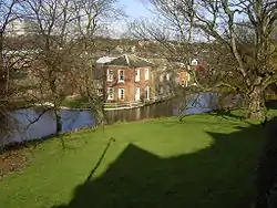 The Porter Brook at Wilson's Sharrow Mill. | |
| Location | |
| Country | England |
| Physical characteristics | |
| Source | |
| • location | Pennines |
| Length | 6.5 mi (10.5 km) |
Route
The Porter Brook rises from a series of springs among the sedge grass of Burbage Moor, the highest of which is close to the 370-metre (1,210 ft) contour near Brown Edge Farm. Its source is just inside the Peak District National Park, to the north-west of the village of Ringinglow. It passes through Clough Hollow, and under Fulwood Lane, where it leaves the National Park.[1] Nearby, at the junction of Fulwood Lane and Greenhouse Lane is a Rotary Club funded toposcope, Finder Cairn, which indicates the direction of local landmarks.[2][3] Just before it reaches the bridge carrying Woodcliffe over it, the river is joined by Mayfield Brook, which rises at a similar level but a little further to the north. Before the junction, Mayfield Brook supplied power to Fulwood corn mill, the highest mill on the system. Soon the combined flow reaches Forge Dam, now a large lake with an island.[1] In Sheffield, "dam" referred to the body of water, rather than the structure which impounded it. Mills used for grinding were known as wheels, and the tail race was known as a goit.[4]
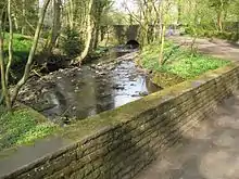
Beyond Forge Dam, where the Porter is defined as a main river, the brook passes Wire Mill Dam, where there is a monument celebrating the life of Thomas Boulsover, the inventor of Sheffield Plate. The grade II listed structure was constructed in 1927 by a Master Cutler called David Flather, and may have been built from materials taken from the Wire Mill.[5] Below Whiteley Wood Road bridge it is joined by a small tributary, flowing northwards from springs in the Porter Valley Woodlands Nature Reserve. Next it reaches Hangingwater Road bridge, a massive structure built around 1800, with two small segmental arches.[6] Immediately below the bridge is the dam for Shepherd's Wheel, with the buildings at its downstream end. The dam, goit, buildings and weir are grade II* listed, as internally, the machinery is complete and still operational. The site is run as a museum.[7]
The river continues through Whiteley Woods, passing Ibbotson dam before crossing under Oakbrook Road and back again to reach Nether Spurgear dam. Oak Brook flows southwards from the grounds of Tapton Hall to join the north bank, and Holme dam is close to the river as it enters Endcliffe Wood.[1] Almost the entire length of the river from Fulwood Lane is part of the grade II listed Porter Valley Parks, a series of green spaces and parks created along the river valley between 1885 and 1938. 20 acres (8.1 ha) of land in Endcliffe Woods, at the eastern end of the linear park, was bought by Sheffield Corporation in 1885, to create public walks and pleasure grounds, but they also had another motive. The river at the time was a serious health risk, as sewage from newly built houses to the north of the river was flowing into the channel. Once they owned the woods, they were able to build a sewer through it. They then asked William Goldring to create a public park in the woods, which included gravelled paths, flower beds, ornamental shrubberies, rustic bridges, seating and a refreshment room. Several dams were repurposed, with Endcliffe dam used for bathing, Holme dam for skating, and Nether Spurgear dam for wildfowl. In 1924, Sheffield's committment to public spaces was recognised by Patrick Abercrombie in his Civic Survey, where he described the Porter Valley parks as "the finest example to be found in this country of a radial park strip, an elongated open space, leading from a built-up part of the city direct into the country."[8]
At the eastern end of Endcliffe Park the river is crossed by the B6069 Brocco Bank road, close to the roundabout on Eccleshall Road, now the A625. Eccleshall Road became a toll road in 1810, and the toll gate is situated in the centre of the roudabout, although it is not in its original location, as it was moved in the early 20th century.[9] Beyoud Brocco Bank is a small bridge built in 1899 to serve the George Woodindin almshouses, arranged in a crescent on the north side of the river.[10] The river then enters a section of culvert, to emerge on the south side of Eccleshall Road, and weaves its way between housing to reach Sharrow Vale dam and snuff mill. The main building, dating from 1737 onwards, straddles the river,[11] with a newer building dating from 1880 to the north, containing the original machinery which was still in use in 2004.[12] At the eastern end of the buildings is a bridge dating from the late 18th century.[13]
The river then runs between Ecclesall Road and Sheffield General Cemetery, past the former Wards brewery.[14] The section of the river from Renton Street, near to the location of Sharrow Forge (No. 15), is now built over running through culverts beneath the intersection of London Road and Eyre Street. It re-emerges by Eyre Street after which it flows alongside Mary Street, beneath the bridge on Matilda Street, through the new Matilda Street Pocket Park and behind the BBC offices on Shoreham Street, passing beneath Leadmill Road towards the culvert at Cross Turner Street outside Sheffield Station. It meets the River Sheaf in tunnels beneath the Station, under Platform 5a.[15] The Sheaf & Porter Rivers Trust intent to replace the wooden access cover on the platform which is directly above the confluence with a steel grating cover, allowing the public to look down into the river and also provide an information board.
Porter Brook derives its name from its brownish colour, similar to the colour of Porter, a brownish discolouration obtained as it passes over iron-ore deposits on its course from the source. The headwaters of the Porter Brook were previously culverted in Victorian times, and were opened up through a daylighting scheme completed in 2013.[16]
Water power
Porter Brook | |||||||||||||||||||||||||||||||||||||||||||||||||||||||||||||||||||||||||||||||||||||||||||||||||||||||||||||||||||||||||||||||||||||||||||||||||||||||||||||||||||||||||||||||||||||||||||||||||||||||||||||||||||||||||||||||||||||||||||||||||||||||||||||||||||||||||||||||||||||||||||||||||||||||||||||
|---|---|---|---|---|---|---|---|---|---|---|---|---|---|---|---|---|---|---|---|---|---|---|---|---|---|---|---|---|---|---|---|---|---|---|---|---|---|---|---|---|---|---|---|---|---|---|---|---|---|---|---|---|---|---|---|---|---|---|---|---|---|---|---|---|---|---|---|---|---|---|---|---|---|---|---|---|---|---|---|---|---|---|---|---|---|---|---|---|---|---|---|---|---|---|---|---|---|---|---|---|---|---|---|---|---|---|---|---|---|---|---|---|---|---|---|---|---|---|---|---|---|---|---|---|---|---|---|---|---|---|---|---|---|---|---|---|---|---|---|---|---|---|---|---|---|---|---|---|---|---|---|---|---|---|---|---|---|---|---|---|---|---|---|---|---|---|---|---|---|---|---|---|---|---|---|---|---|---|---|---|---|---|---|---|---|---|---|---|---|---|---|---|---|---|---|---|---|---|---|---|---|---|---|---|---|---|---|---|---|---|---|---|---|---|---|---|---|---|---|---|---|---|---|---|---|---|---|---|---|---|---|---|---|---|---|---|---|---|---|---|---|---|---|---|---|---|---|---|---|---|---|---|---|---|---|---|---|---|---|---|---|---|---|---|---|---|---|---|---|---|---|---|---|---|---|---|---|---|---|---|---|---|---|---|---|---|---|---|---|---|---|---|---|---|---|---|---|---|---|---|---|
| |||||||||||||||||||||||||||||||||||||||||||||||||||||||||||||||||||||||||||||||||||||||||||||||||||||||||||||||||||||||||||||||||||||||||||||||||||||||||||||||||||||||||||||||||||||||||||||||||||||||||||||||||||||||||||||||||||||||||||||||||||||||||||||||||||||||||||||||||||||||||||||||||||||||||||||
The Porter Brook, like the other rivers in Sheffield, is ideally suited for providing water power, as the final section falls some 450 feet (140 m) in a little over 4 miles (6.4 km). This enabled dams to be constructed reasonably close together, without the outflow from one mill being restricted by the next downstream dam.[17] In addition to this water-power, natural sandstone was available in abundance in the nearby hills of Sheffield and the Peak District National Park. Lying at the edge of these hills, mill-owners found Millstone Grit was an easily extractable resource. By 1740 Sheffield became the most extensive user of water-power in Britain and probably in Europe. Ninety mills had been built, two-thirds of them for grinding. By 1850 these mills numbered well over 100. In the Porter valley alone 21 mill dams served 19 water-wheels, mostly used for grinding corn, operating forge-hammers, and rolling mills, grinding knives and the various types of blade that made Sheffield famous. Most were active during the 18th and 19th centuries.
- Fulwood Cornmill
A mill is known to have existed at Fulwood in 1641, when Ulysses Fox its builder appeared before the Court of Kings Bench changed with "trespass", as the rights to grind corn were owned by the manor. Despite having to pay £35 8s 9d (£35.43) the mill survived. Later, there were two wheels served by two dams[18] lying between Mill Lane and Mark Lane in Mayfield Valley above Forge Dam. In 1760 the mill was used by Thomas Boulsover for the production of Sheffield-plate buttons. A steam engine was used at the Nether or lower mill from 1847, and both were unused by 1884. The complex was given to Sheffield Corporation in 1937, but most of it has since been demolished. Unlike most installations in Sheffield, the dam impounded the whole of the flow from the Mayfield Brook, with the result that the dam (the normal local term for the lake, rather than the structure that creates the lake) has completely silted up.[18]
Thomas Boulsover first used this site for the production of writing paper, but this was unsuccessful, as the water contained ochre. By 1765, it had become a forge and rolling mill, and by 1832 was used for the production of saws, while two drop-hammers were used to beat heated metal ingots into wrought-iron. Two water wheels were supplemented by a steam engine in 1835, and the operation ceased around 1887. A showman called Herbert Maxfield used the dam as a boating pool between 1900 and 1920, and the site was bought by Sheffield Corporation in 1939. The workers’ cottages became a café. The 40-foot (12 m) weir is still in good condition, but the dam has suffered from silting, as its layout was similar to the Fulwood dam.[4]
- Wiremill Dam (extant) Previously Whiteley Wood Rolling Mill, also known as Bowser Bottom or Thomas Boulsover's Rolling Mill.
The mill produced thin steel plate suitable for sawplate and for other items fashioned from strip steel, and wire used mainly in the cutlery industry. Wiremill Dam was once the site of the largest diameter water-wheel in Sheffield. Two overshot wheels were recorded in 1829, each 34.5 feet (10.5 m) in diameter and 4.25 feet (1.30 m) wide. They rotated at 6 rpm and were fed by a head of water of about 10 feet (3.0 m).[20]
- Nether Wheel
- Shepherd Wheel (extant)
This was originally called Porter Wheel, and was mentioned in a will read in 1566. From 1749, it was leased to Edward Shepherd, and the wheel was then known by his name. He worked there until he died in 1794, when it passed to his son-in-law. Samuel Hind began working there when aged ten in 1818, and the Hind(e) family were associated with it until about 1930, when commercial opration ceased. The leaseholder was John Eyre, who bought the wheel from the Duke of Norfolk's estate in 1811, and ownership passed to Sheffield Corporation in the late 1890s, although the transaction was not completed until 1908. After 1930, the wheel was maintained and occasionally demonstrated by the forerunner of the South Yorkshire Industrial History Society until 1941. Its condition deteriorated, and it was almost demolished, but the Council for the Conservation of Sheffield Antiquities renovated it, and it was given to the City Museums.[21] It is now run as a museum by the Sheffield Industrial Museums Trust.
- Ibbotson’s Wheel (extant) previously Upper Spurgear Wheel or 4th Endcliffe Wheel.
The first wheel on this site was erected by Stephen Hawksworth in 1754, but it was operated by Josepoh Ibbotson from 1759, and became known by his name from 1775. After his death, it was bought by Ebenezer Marsden, who opposed the Water Works Bill in 1835, and was charged an extra £7 rate because of his stance. In 1847, the wheel was subjected to rattening, when unknown people entered the building and broke five of the grindstones. Ownership was transferred to Sheffield Corporation, who gave the Ibbotsons notice to quit in 1902. A proposal in the 1930s for it to become an industrial museum came to nothing, and it was demolished around 1950.[22] During the early 1900s the dam became Porter Glen Boating Lake.
- Nether Spurgear Wheel (extant) also known as 3rd Endcliffe Wheel
- Second Endcliffe Wheel
- Holme Wheel (extant) also known as Nether Mill, Leather Wheel, or Whiteley Woods Bottoms Wheel (1754).
The dam became Endcliffe Boating Lake when Endcliffe Park was re-opened in 1887 to commemorate the Jubilee of Queen Victoria following major re-design and landscaping by landscape architect William Goldring. Porter Valley Parks are all part of the Sheffield Round Walk.
- First Endcliffe Wheel
For a short while this dam at Hunter's Bar became Endcliffe Bathing Pool. It was closed at the outbreak of World War II. Some 20 years later it was drained and filled in.
- Upper Lescar Wheel This cutlers wheel and the Nether Lescar Wheel took their names from the marshy area, Leeche Carr by the Porter Brook,[23] carr (or kjarr) being Old Norse for a wetland undergoing transition to a woodland. The wheel existed in 1587. This dam was to supply power to the Porter Steel Works until 1890 when the works closed.
- Nether Lescar Wheel Dam Records indicate that this cutlers wheel existed in 1587. In 1630 John Bamforth paid £2-00 and two hens per annum to the Lord of the Manor to rent this wheel. This dam also supplied power to the Porter Steel Works.[23]
- Porter Works Dam
Both Lescar Wheels and Porter Works Dams were drained to provide housing between Ecclesall Road and Sharrow Vale Road.
Sharrow Wheel was in use by cutlers by 1604, and was sometimes known as Bamforth Wheel, as it was leased to members of the Bamforth family from then until 1719. In the mid 1740s, Joseph Wilson enlarged the wheel, and in 1757 plans were drawn up for changes to the tail goit, which was carried under the river in a culvert, to rejoin the river further downstream. A snuff mill was erected in 1763, and the cutler wheel was not mentioned subsequently. The Wilson family bought the freehold from the Duke of Norfolk's estate in 1798, and have run the mill ever since. The water-powered snuff grinding equipment remains in place, although it is no longer used to grind snuff commerically.[24]
- Stalker Wheel also known as Three-Square Dams
Lying between Ecclesall Road and the high wall stone wall of Sheffield General Cemetery.
- Sharrow Forge
Drained and filled in, c. 1870. The land was developed to build houses in Napier Street and St Matthias Primary School.
- Broomhall Cornmill
Also drained and filled in, c. 1870.
- Bennett's Wheel also known as Little Sheffield Moor or Vulcan Works Dam
The original grinding wheel (1810–1851) closed and the dam was leased to the Vulcan Works a forge, and rolling-mill providing water for boilers.
- Leadmill Dam also known as Marriott's Wheel (1732–1780s).
The White Lead Works was erected in 1759 producing pigments for paint and pottery glazes and continued in use until the later 19th century. When it closed, the dam was filled in and the site used to construct a tram-depot c. 1910.
- Ponds Lane Dam[25]
The Peak Park Anniversary Cycle Route follows the Porter Brook from Bingham Park to Porter Clough near Ringinglow.
Water quality
The Environment Agency measure the water quality of the river systems in England. Each is given an overall ecological status, which may be one of five levels: high, good, moderate, poor and bad. There are several components that are used to determine this, including biological status, which looks at the quantity and varieties of invertebrates, angiosperms and fish, and chemical status, which compares the concentrations of various chemicals against known safe concentrations. Chemical status is rated good or fail. The Porter Brook is designated as "heavily modified", which means that the channels have been altered by human activity, and the criteria for this designation are defined by the Water Framework Directive.[26]
The water quality of the Porter Brook was as follows in 2019.
| Section | Ecological Status | Chemical Status | Overall Status | Length | Catchment |
|---|---|---|---|---|---|
| Porter from Source to River Sheaf[27] | Moderate | Fail | Moderate | 4.8 miles (7.7 km) | 6.59 square miles (17.1 km2) |
The water quality in the river has deteriorated since 2009, when it was rated good for ecological and overall status. Like many rivers in the UK, the chemical status changed from good to fail in 2019, due to the presence of polybrominated diphenyl ethers (PBDE), perfluorooctane sulphonate (PFOS) and mercury compounds, none of which had previously been included in the assessment.
In popular culture
The river is one of several which inspired the song "Wickerman" by Pulp.[28]
The Sheffield morris dance group, Five Rivers Morris, who take their name from the city's waterways, have a dance called 'Porter' after the Porter Brook.[29]
The Porter Brook featured heavily in a 2016 BBC Radio 4 documentary entitled "A River of Steel",[30] produced by sound recordist Chris Watson, ex-member of Caberet Voltaire. The programme includes discussion of the recently completed Porter Brook daylighting scheme, which also features in a 2017 article in The Guardian.[31]
Planned flood alleviation programme
In September 2014 Sheffield City Council announced plans for a flood alleviation scheme on the Porter Brook and its tributary the Mayfield Brook. It is planned to create storage dams at Mayfield, Whiteley Woods and Endcliffe Park. Downstream of Endcliffe Park, parts of the watercourse will be contained by walled defences.[32][33]
Points of interest
| Point | Coordinates (Links to map resources) |
OS Grid Ref | Notes |
|---|---|---|---|
| Junction with River Don | 53.3853°N 1.4622°W | SK358877 | by Blonk Street bridge |
| Start of Sheffield Station culvert | 53.3771°N 1.4632°W | SK358868 | |
| Porter Brook daylighting scheme | 53.3756°N 1.4679°W | SK354866 | |
| Start of St Mary's Gate culvert | 53.3725°N 1.4818°W | SK345863 | |
| Sharrow Snuff Mill | 53.3685°N 1.4930°W | SK338858 | |
| A625 Ecclesall Road bridge | 53.3685°N 1.4990°W | SK334858 | |
| Oakbrook Road bridge | 53.3685°N 1.5205°W | SK320858 | |
| Fulwood Lane bridge | 53.3532°N 1.5742°W | SK284841 | |
| Clough Hollow | 53.3530°N 1.5780°W | SK281840 | source |
Culverts
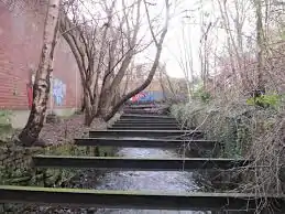
Although the 'Megatron' arches which carry the combined waters of the River Sheaf and Porter Brook under Sheffield Station and the Castlegate area, the Porter Brook is also heavily culverted as it meets the city.
As the Porter Brook descends from behind Ward's brewery, it runs under Waitrose, briefly emerging beside Baan Thai on Cemetery road. It then continues under the ring road until meeting Decathlon's car park where a section of culvert has recently been removed, opening more of the river up to the public.
Sheaf & Porter Rivers Trust
In early 2019, the Sheaf & Porter Rivers Trust was set up to encourage the regeneration and improvement of the River Sheaf & Porter Brook.[34]
Aims and Objectives of the Organisation
- Deculverting – the first priority is likely seizing the immediate opportunity at the Castle Market site where a 100 metre section of culvert is in an advanced state of decay and requires repair or removal. Other possible opportunities may arise from the master planning of the lower Sheaf Valley around the accommodation of High Speed Rail 2 at Midland Station – for instance the section of culverted river which runs between Ponds Forge leisure centre and Sheaf Street
- Daylighting – whilst removal of the culverts under the railway tracks of Midland Station is probably unrealistic the potential of sinking light‐pipes into the dark tunnels to allow fish and animal passage could be considered as part of the environmental mitigation of the scheme c) Improved public access to existing open channel sections and newly deculverted ones including access for fishing, kayaking and stewardship eg Pond Hill, Sheaf Gardens, Cutlers Walk, the Primrose etc
- Marking, celebrating the concealed course of the river where it remains hidden for now, using public art, trails etc and guided visits using trained guides
- Interpretation of the river’s history, wildlife and environmental functions and engagement with its neighbouring communities
- Promotion of good practice by riparian owners
- More sustainable urban drainage in the Sheaf corridor following the example of Grey to Green
Porter Brook Path
A new riverside path is planned between where the Porter Brook first goes underground at Hunters Bar Roundabout, through Sharrowvale, past the general cemetery and towards the cultural industries quarter. From here, it will meet the Matilda Street Pocket Park and continue to Sheffield Station.
This is a long term plan and current relies on several riverside redevelopment sites which have promised to create new sections of riverside walk.
Matilda Street Pocket Park
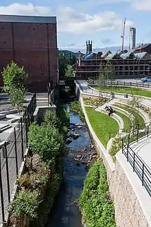
The Matilda Street Pocket Park was one of Sheffield's first examples of natural flood management in an urban environment. The newly created pocket park provides both a public park and extra space for the previously narrow river to hold back and slow flood water.[35]
The new park was a joint effort between South Yorkshire Forest, the Environment Agency, Wild Trout Trust and Sheffield City Council.
The project was announced as the Winner in the ‘Contribution to the Built Environment’ category at the 2016 Living Waterways Awards ceremony, held at Birmingham Town Hall (14 September 2016)[36]
Funding came from the Councils City Centre Breathing Spaces programme, the Environment Agency Local Levy and the European Union under the Interreg IVB SEEDS project, which funded the Feasibility Study.
Bibliography
- Armstrong, Julia (16 April 2020). "Fancy a pint of Ward's". The Star. Archived from the original on 27 April 2020.
- Ball, Christine; Crossley, David; Flavell, Neville (2006). Water Power on the Sheffield Rivers: Second Edition. South Yorkshire Industrial History Society. ISBN 978-0-9556644-0-3.
- Wild, T. C.; Dempsey, N.; Broadhead, A. T. (April 2019). "Volunteered information on nature-based solutions — Dredging for data on deculverting" (PDF). Urban Forestry and Urban Greening. 40 (1). doi:10.1016/j.ufug.2018.08.019.
References
- Ordnance Survey, 1:25,000 map
- "Walking with Ramblers: Walk 2 Mayfield and Porter Valleys" (PDF). Sheffield City Council. Retrieved 18 August 2019.
- Goodwin, David (20 November 2009). "Geograph:: Rotary Orientation table (C) David M Goodwin". www.geograph.org.uk. Retrieved 18 August 2019.
- Ball, Crossley & Flavell 2006, pp. 117–118.
- Historic England. "Monument to Thomas Boulsover (1254492)". National Heritage List for England. Retrieved 5 February 2021.
- Historic England. "Bridge spanning Porter Brook (1255067)". National Heritage List for England. Retrieved 5 February 2021.
- Historic England. "Shepherd Wheel and attached dam goit and weir (1255068)". National Heritage List for England. Retrieved 5 February 2021.
- Historic England. "Porter Valley Parks (1001502)". National Heritage List for England. Retrieved 5 February 2021.
- Historic England. "Hunters Bar Toll Gate (1270820)". National Heritage List for England. Retrieved 5 February 2021.
- Historic England. "Bridge and lamp near George Woodindin Almshouses (1247588)". National Heritage List for England. Retrieved 5 February 2021.
- Historic England. "Sharrow Mills (1247589)". National Heritage List for England. Retrieved 5 February 2021.
- Historic England. "New mill building at Sharrow Mills (1247592)". National Heritage List for England. Retrieved 5 February 2021.
- Historic England. "Bridge to east of Sharrow Mills (1247590)". National Heritage List for England. Retrieved 5 February 2021.
- "City Policies and-Sites" (PDF). www.sheffield.gov.uk. Sheffield City Council. 3 April 2013. Retrieved 17 March 2017.
- 53.3786°N 1.4630°W
- Wild, Dempsey & Broadhead 2019, pp. 254-263.
- Ball, Crossley & Flavell 2006, p. 114
- Ball, Crossley & Flavell 2006, pp. 115–117
- "Regeneration of Porter Brook". Sheffield City Council. Archived from the original on 2 December 2008. Retrieved 10 January 2018.
- Ball, Crossley & Flavell 2006, pp. 119–121.
- Ball, Crossley & Flavell 2006, pp. 123–125.
- Ball, Crossley & Flavell 2006, pp. 126–127.
- Signboards erected in Eastwood Road micro park
- Ball, Crossley & Flavell 2006, pp. 134–136.
- OS Map 1810
- "Glossary (see Biological quality element; Chemical status; and Ecological status)". Catchment Data Explorer. Environment Agency. Retrieved 15 May 2017.
- "Porter from Source to River Sheaf". Catchment Data Explorer. Environment Agency. Retrieved 21 August 2019.
- "Wickerman (song)". Retrieved 5 December 2011.
- "Five Rivers Morris repertoire | Five Rivers Morris". www.fiveriversmorris.org.uk. Retrieved 13 February 2017.
- "A River of Steel (Radio Programme)". Retrieved 8 September 2017.
- "A river runs through it (Article)". Retrieved 8 September 2017.
- "Sheaf Catchment Options Map | Protecting Sheffield from Flooding". www.floodprotectionsheffield.com. Retrieved 9 November 2017.
- "£55m flood defence plans revealed". BBC News. 11 September 2014. Retrieved 9 November 2017.
- https://www.sheafportertrust.org/about-us Sheaf & Porter Rivers Trust
- "matilida street pocket park - Google Search". www.google.com. Retrieved 7 July 2020.
- Council, Sheffield City. "Porter Brook Pocket Park wins prestigious Living Waterways Award | Sheffield Newsroom | Sheffield City Council". Retrieved 7 July 2020.
External links
- Sheffield City Library – historical photographs, prints, and old postcards
- Friends of the Porter Valley – preserving the past and existing dams
![]() Media related to Porter Brook at Wikimedia Commons
Media related to Porter Brook at Wikimedia Commons