Prévost, Quebec
Prévost is a town within the La Rivière-du-Nord Regional County Municipality, Quebec, Canada, and the administrative region of Laurentides in the Laurentian Mountains, north of Montreal. It was created in 1973 from the amalgamation of the former villages of Shawbridge and Lesage with old Prévost on the other side of the Rivière du Nord. Shawbridge was named after William Shaw (1805-1894) who settled in the township of Abercromby in 1847 and built the first bridge over the Rivière du Nord.[4]
Prévost | |
|---|---|
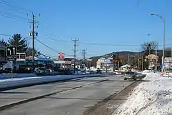 Highway 117 in Prévost | |
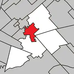 Location within La Rivière-du-Nord RCM | |
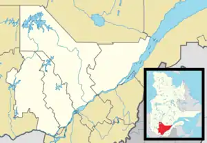 Prévost Location in central Quebec | |
| Coordinates: 45°52′N 74°05′W[1] | |
| Country | |
| Province | |
| Region | Laurentides |
| RCM | La Rivière-du-Nord |
| Settled | 1842 |
| Constituted | January 20, 1973 |
| Government | |
| • Mayor | Paul Germain |
| • Federal riding | Rivière-du-Nord |
| • Prov. riding | Bertrand |
| Area | |
| • Total | 35.10 km2 (13.55 sq mi) |
| • Land | 35.05 km2 (13.53 sq mi) |
| Population | |
| • Total | 12,171 |
| • Density | 347.2/km2 (899/sq mi) |
| • Pop 2006-2011 | |
| Time zone | UTC−5 (EST) |
| • Summer (DST) | UTC−4 (EDT) |
| Postal code(s) | J0R |
| Area code(s) | 450 and 579 |
| Highways | |
| Website | www |
It is known for its cross-country skiing and for the Shawbridge Boys' Farm, a youth detention centre operated by Batshaw Youth Services.[5] Route 117, also known as Curé-Labelle Boulevard, is the town's main street crossing the city from south to north. Autoroute 15, the Laurentian Autoroute, also serves the town. The city's main roads also include chemin du Lac-Écho and rue de la Station which both lead to nearby Saint-Hippolyte, Quebec.
Prévost was formerly known as Shawbridge until 1973.
Police services are provided by the Sûreté du Québec, the provincial police force.
.JPG.webp)
Shawbridge was formerly served by freight and passenger services of the Canadian Pacific Railway. The Prévost railway station is now a community centre and stop on the Parc Linéaire Le P'tit Train du Nord bicycle and hiking trail.
Shawbridge and old Prévost were traditionally linked by the Shaw bridge, built in 1923 as a replacement for William Shaw's wooden bridge, over the Rivière du Nord. The bridge was closed by the Quebec government in late June 2008 as unsafe, forcing pedestrians to walk along the highway, but local residents and the town's mayor, Claude Charbonneau, have asked that the bridge be reopened, at least for pedestrian and bicycle traffic.[6][7] The Quebec Ministry of Transport reopened the bridge on August 28, 2008, but only for pedestrians and bicyclists.
Demographics
Population trend:[8]
- Population in 2011: 11,747 (2006 to 2011 population change: 15.9%)
- Population in 2006: 10,132 (2001 to 2006 population change: 22.4%)
- Population in 2001: 8280
- Population in 1996: 7308
- Population in 1991: 6024
Private dwellings occupied by usual residents: 4,749 (total dwellings: 5,015)
Mother tongue:
- English as first language: 3%
- French as first language: 94%
- English and French as first language: 1%
- Other as first language: 2%
Education
Commission scolaire de la Rivière-du-Nord operates Francophone schools:[9]
- Champ-Fleuri, Val-des-monts, Des Falaises
- École polyvalente Saint-Jérôme in Saint-Jérôme
Sir Wilfrid Laurier School Board operates English-language public schools. Schools serving the town:
- Morin Heights Elementary School in Morin-Heights[10]
- Laurentian Regional High School in Lachute[11]
Previously Batshaw High School was in Prévost.[12]
References
- Reference number 353852 of the Commission de toponymie du Québec (in French)
- Geographic code 75040 in the official Répertoire des municipalités (in French)
- "(Code 2475040) Census Profile". 2011 census. Statistics Canada. 2012.
- "Commission de toponymie du Quebec: former village of Shawbridge". Archived from the original on 2008-09-15. Retrieved 2008-09-04.
- Batshaw
- Valiante, Giuseppe (August 29, 2008). "Prévost residents fight to save bridge". The Gazette (Montreal). Archived from the original on November 5, 2012. Retrieved 2008-09-01.
- RAPPEL/Comité du pont de Shawbridge : Dimanche à 15 heures sur la route 117. 2008-08-17 Accessed 2008-09-04 (in French)
- Statistics Canada: 1996, 2001, 2006, 2011 census
- "Trouver une école ou un centre." Commission scolaire de la Rivière-du-Nord. Retrieved on September 24, 2017. For attendance boundary information, click "Par bassin d'école"
- "MORIN HEIGHTS ELEMENTARY ZONE." Sir Wilfrid Laurier School Board. Retrieved on September 16, 2017.
- "LAURENTIAN REGIONAL HS ZONE." Sir Wilfrid Laurier School Board. Retrieved on September 4, 2017.
- "Schools 2000-2001." Sir Wilfrid Laurier School Board. August 7, 2001. Retrieved on September 18, 2017.
External links
| Wikimedia Commons has media related to Prévost, Quebec. |
Places adjacent to Prévost, Quebec | |
|---|---|
| Towns | |
|---|---|
| Municipalities | |
| |
| Authority control |
|---|