Sainte-Sophie, Quebec
Sainte-Sophie is a municipality in the Laurentides region of Quebec, Canada, part of the La Rivière-du-Nord Regional County Municipality.
Sainte-Sophie | |
|---|---|
 | |
Logo | |
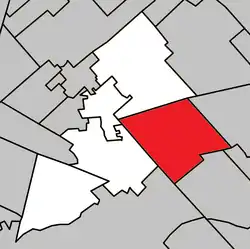 Location within La Rivière-du-Nord RCM | |
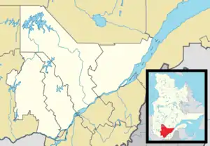 Ste-Sophie Location in central Quebec | |
| Coordinates: 45°49′N 73°54′W[1] | |
| Country | |
| Province | |
| Region | Laurentides |
| RCM | La Rivière-du-Nord |
| Constituted | May 3, 2000 |
| Government | |
| • Mayor | Louise Gallant |
| • Federal riding | Rivière-du-Nord |
| • Prov. riding | Rousseau |
| Area | |
| • Total | 111.50 km2 (43.05 sq mi) |
| • Land | 111.28 km2 (42.97 sq mi) |
| Population (2011)[3] | |
| • Total | 13,375 |
| • Density | 120.2/km2 (311/sq mi) |
| • Pop 2006-2011 | |
| Time zone | UTC−5 (EST) |
| • Summer (DST) | UTC−4 (EDT) |
| Postal code(s) | J5J |
| Area code(s) | 450 and 579 |
| Highways | |
| Website | www |
History
The new Municipality of Sainte-Sophie was created on May 2, 2000, when the old Municipality of Sainte-Sophie was merged with the Village Municipality of New Glasgow.
Demographics
Population trend:[4]
- Population in 2011: 13375 (2006 to 2011 population change: 29.2%)
- Population in 2006: 10,355 (2001 to 2006 population change: 15.5%)
- Population in 2001: 8966
- Population in 1996: 8691
- Sainte-Sophie: 8534
- New Glasgow: 157
- Population in 1991:
- Sainte-Sophie: 7377
- New Glasgow: 167
Private dwellings occupied by usual residents: 5,162 (total dwellings: 5,437)
Education
The Commission scolaire de la Rivière-du-Nord operates French-language public schools.[5]
- École primaire du Joli-Bois
- École primaire Jean-Moreau
- École primaire Sainte-Sophie
- The primary school Sacré-Coeur in Saint-Jérôme serves a section
- École secondaire Cap-Jeunesse and École secondaire des Hauts-Sommets in Saint-Jérôme
Sir Wilfrid Laurier School Board operates English-language public schools. Schools serving the town:
- Laurentia Elementary School in Saint-Jérôme[6]
- Laurentian Regional High School in Lachute[7]
References
- Reference number 56411 of the Commission de toponymie du Québec (in French)
- Geographic code 75028 in the official Répertoire des municipalités (in French)
- "(Code 2475028) Census Profile". 2011 census. Statistics Canada. 2012.
- Statistics Canada: 1996, 2001, 2006, 2011 census
- "Trouver une école ou un centre." Commission scolaire de la Rivière-du-Nord. Retrieved on September 24, 2017. For attendance boundary information, click "Par bassin d'école"
- "LAURENTIA ELEMENTARY ZONE." Sir Wilfrid Laurier School Board. Retrieved on September 4, 2017.
- "LAURENTIAN REGIONAL HS ZONE." Sir Wilfrid Laurier School Board. Retrieved on September 4, 2017.
External links
 Media related to Sainte-Sophie at Wikimedia Commons
Places adjacent to Sainte-Sophie, Quebec | |
|---|---|
| Towns | |
|---|---|
| Municipalities | |
| |
| Authority control |
|---|
This article is issued from Wikipedia. The text is licensed under Creative Commons - Attribution - Sharealike. Additional terms may apply for the media files.