Prince Edward Island Route 1A
Route 1A is a 20-kilometre (12 mi) long provincial highway in central Prince Edward Island. The route is a spur route of the Route 1 which connects the Trans-Canada Highway near Borden-Carleton and the Confederation Bridge with the city of Summerside.[2] It is an uncontrolled access 2-lane highway with a maximum speed limit of 90 km/h (55 mph) and is considered a "Core route" of Canada's National Highway System.[3] Route 1A is unnamed except for the portion within Summerside city limits, where it is known as Read Drive.[2]
| ||||
|---|---|---|---|---|
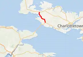
Route 1A highlighted in red. | ||||
| Route information | ||||
| Auxiliary route of Route 1 (TCH) | ||||
| Length | 20.2 km[1] (12.6 mi) | |||
| Major junctions | ||||
| South end | ||||
| North end | ||||
| Location | ||||
| Counties | Prince | |||
| Major cities | Summerside | |||
| Highway system | ||||
Provincial highways in Prince Edward Island
| ||||

Major intersections
The entire route is in Prince County.
| Location | km[1] | mi | Destinations | Notes | |
|---|---|---|---|---|---|
| Albany | 0.0 | 0.0 | Interchange | ||
| 0.7 | 0.43 | ||||
| | 1.3 | 0.81 | |||
| Middletown | 5.0 | 3.1 | |||
| 5.3 | 3.3 | Intersections offset; 50 m (160 ft) concurrency | |||
| | 6.4 | 4.0 | |||
| 9.5 | 5.9 | ||||
| Central Bedeque | 10.1 | 6.3 | |||
| | 12.5 | 7.8 | |||
| 13.0 | 8.1 | ||||
| 16.2 | 10.1 | ||||
| Summerside | 17.1 | 10.6 | |||
| 18.4 | 11.4 | ||||
| Travellers Rest | 20.2 | 12.6 | Roundabout | ||
1.000 mi = 1.609 km; 1.000 km = 0.621 mi
| |||||
References
- Google (August 11, 2019). "PEI Route 1A - Length and route" (Map). Google Maps. Google. Retrieved August 11, 2019.
- Prince Edward Island Transportation and Infrastructure Renewal (2014). Provincial Road Atlas - Prince Edward Island (PDF) (Map). 1:50,000. Government of Prince Edward Island. pp. 15, 19, 20. Retrieved August 11, 2019.
- "Canada's National Highway System Annual Report 2017" (PDF). Council of Ministers Responsible for Transportation and Highway Safety. January 2019. p. 42. Retrieved 11 August 2019.
This article is issued from Wikipedia. The text is licensed under Creative Commons - Attribution - Sharealike. Additional terms may apply for the media files.