Prince Edward Island Route 2
Route 2, also known as Veterans Memorial Highway and the All Weather Highway, is a 216-kilometre (134 mi) two-lane uncontrolled access highway traversing Prince Edward Island, Canada from Tignish to Souris.[2] Route 2 was recognized as the first numbered highway in the province in 1890, when it opened between Charlottetown and Summerside.
| ||||
|---|---|---|---|---|
| All Weather Highway Veterans Memorial Highway | ||||
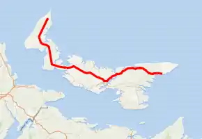
Route 2 highlighted in red. | ||||
 | ||||
| Route information | ||||
| Maintained by Department of Transportation, Infrastructure, and Energy | ||||
| Length | 217.1 km[1] (134.9 mi) | |||
| Existed | 1890–present | |||
| Major junctions | ||||
| West end | ||||
| ||||
| East end | ||||
| Location | ||||
| Counties | Kings, Queens, Prince | |||
| Major cities | Charlottetown, Summerside | |||
| Highway system | ||||
Provincial highways in Prince Edward Island
| ||||

It passes through the cities of Summerside and Charlottetown and roughly parallels the former primary railway line through the province, which was abandoned in 1989.
The highway was first paved in the 1950s with many upgrades in recent decades. A perimeter arterial highway (ring road) across the northern and eastern part of Charlottetown was constructed as part of Route 2 in the 1990s with funding from a $200 million federal adjustment fund for road construction after the railway was abandoned. This section of road was extended to Upton Road and is now signed for Route 1 (the Trans-Canada Highway), although Route 2 uses a small portion of the arterial highway between the Malpeque Road and St. Peter's Highway.
Names
Route 2 is commonly called the "All Weather Highway," as it was one of the first roads in Prince Edward Island to be open for traffic in all seasons. In 2003 the highway was designated "Veterans Memorial Highway", the same year that it qualified for federal infrastructure funding for much-needed capacity upgrades.
Route 2 has several local names:
- Souris Road (Souris to Route 4 at Dingwells Mills)
- St. Peter's Highway (Dingwells Mills to Charlottetown)
- Malpeque Road (Charlottetown to Hunter River); the Malpeque Road alignment continuing thereafter on the Old Princetown Road
- New Annan Road (Kensington to Summerside)
- Western Road (Summerside to Tignish)
Mount Pleasant diversion
The portion of the highway running through the farming hamlet of Mount Pleasant west of Summerside was diverted for several years during the 1940s with the establishment of an air force base named RCAF Station Mount Pleasant.[3] The base was closed following World War II and the "Western Road" was returned to its original alignment which currently runs along the former flight line and tarmac of the air force base. The diversion road constructed around the base is still in use as a local public road.
Major intersections
| County | Location | km[1] | mi | Destinations | Notes |
|---|---|---|---|---|---|
| Prince | | −1.4 | −0.87 | ||
| Tignish | 0.0 | 0.0 | Western terminus | ||
| 1.3 | 0.81 | ||||
| | 2.1 | 1.3 | |||
| St. Peter and St. Paul | 4.5 | 2.8 | |||
| Profits Corner | 11.1 | 6.9 | |||
| Alma | 12.5– 12.6 | 7.8– 7.8 | Intersections offset; 80 m (260 ft) concurrency | ||
| Elmsdale | 16.9 | 10.5 | |||
| Rosebank | 20.1 | 12.5 | |||
| Bloomfield Corner | 24.2 | 15.0 | Roundabout | ||
| | 26.1 | 16.2 | |||
| St. Anthony | 26.8 | 16.7 | |||
| 27.0 | 16.8 | ||||
| Woodstock | 29.2 | 18.1 | Roundabout | ||
| Carleton | 31.9 | 19.8 | |||
| 37.6 | 23.4 | ||||
| West Devon | 35.9 | 22.3 | |||
| | 37.6 | 23.4 | West end of Route 12 concurrency | ||
| Portage | 40.3 | 25.0 | East end of Route 12 concurrency | ||
| Inverness | 42.7 | 26.5 | |||
| | 46.2 | 28.7 | |||
| 49.9 | 31.0 | ||||
| Mount Pleasant | 50.3 | 31.3 | |||
| | 51.0 | 31.7 | |||
| Springhill | 54.4 | 33.8 | |||
| | 55.6 | 34.5 | |||
| 56.5 | 35.1 | ||||
| Richmond | 59.2 | 36.8 | |||
| | 55.6 | 34.5 | |||
| 62.6 | 38.9 | ||||
| Wellington Centre | 63.8 | 39.6 | |||
| | 65.2 | 40.5 | |||
| 68.8 | 42.8 | ||||
| Miscouche | 74.0 | 46.0 | |||
| Summerside | 80.7 | 50.1 | Central Street | Former Route 121 | |
| 81.0 | 50.3 | Granville Street | Roundabout | ||
| 82.0 | 51.0 | ||||
| Travellers Rest | 84.1 | 52.3 | Roundabout | ||
| | 86.4– 86.5 | 53.7– 53.7 | Intersections offset; 120 m (390 ft) concurrency | ||
| New Annan | 88.2 | 54.8 | |||
| | 89.5 | 55.6 | West end of Route 110 concurrency | ||
| 89.8 | 55.8 | East end of Route 110 concurrency | |||
| Kensington | 92.6 | 57.5 | |||
| 93.0 | 57.8 | ||||
| Norboro | 96.2– 96.3 | 59.8– 59.8 | Intersections offset; 90 m (300 ft) concurrency | ||
| | 98.9 | 61.5 | |||
| Prince—Queens county line | | 99.1 | 61.6 | ||
| Queens | Summerfield | 100.4– 100.6 | 62.4– 62.5 | Intersections offset; 160 m (520 ft) concurrency | |
| Springfield | 103.7 | 64.4 | |||
| | 106.1 | 65.9 | |||
| 108.1 | 67.2 | ||||
| Pleasent Valley | 108.6 | 67.5 | |||
| Fredericton | 111.0 | 69.0 | |||
| Hazelgrove | 112.6 | 70.0 | |||
| | 114.6 | 71.2 | |||
| 115.0 | 71.5 | ||||
| Hunter River | 117.4 | 72.9 | |||
| Greenville | 120.5 | 74.9 | |||
| Brookfield | 123.4– 123.5 | 76.7– 76.7 | Intersections offset; 100 m (330 ft) concurrency | ||
| | 124.4 | 77.3 | |||
| Springvale | 126.8 | 78.8 | West end of Route 256 concurrency | ||
| 127.3 | 79.1 | East end of Route 256 concurrency | |||
| Milton Station | 129.3 | 80.3 | |||
| 130.2 | 80.9 | ||||
| | 131.5 | 81.7 | |||
| Charlottetown | 133.2 | 82.8 | |||
| 135.7 | 84.3 | Route 2 branches east onto Perimeter Highway; west end of Route 1 concurrency | |||
| 136.5 | 84.8 | Mount Edward Road | |||
| 137.4 | 85.4 | ||||
| 138.9 | 86.3 | Route 2 branches east onto St. Peters Road; east end of Route 1 concurrency | |||
| Marshfield | 142.2 | 88.4 | |||
| | 145.6 | 90.5 | |||
| 147.5 | 91.7 | ||||
| Bedford Corner | 149.1 | 92.6 | |||
| | 150.2 | 93.3 | West end of Route 260 concurrency | ||
| 150.5 | 93.5 | East end of Route 260 concurrency | |||
| Tenmile House | 151.9 | 94.4 | |||
| Tracadie Cross | 154.5 | 96.0 | |||
| Mount Stewart | 162.0 | 100.7 | |||
| St. Andrews | 163.6 | 101.7 | |||
| Kings | | 165.3 | 102.7 | ||
| Canavoy | 168.5 | 104.7 | |||
| | 172.8 | 107.4 | |||
| Morell | 176.9 | 109.9 | |||
| Morell East | 178.3 | 110.8 | |||
| Marie | 181.5 | 112.8 | |||
| Midgell | 182.8 | 113.6 | |||
| St. Peters Bay | 187.2 | 116.3 | West end of Route 313 concurrency | ||
| 187.5 | 116.5 | East end of Route 313 concurrency | |||
| | 193.2 | 120.0 | |||
| Dingwells Mills | 200.2 | 124.4 | |||
| | 201.5 | 125.2 | |||
| Fortune Bridge | 204.9 | 127.3 | |||
| Rollo Bay West | 206.5 | 128.3 | |||
| 206.8 | 128.5 | ||||
| | 209.2 | 130.0 | |||
| Rollo Bay | 210.9 | 131.0 | |||
| Souris West | 213.5 | 132.7 | |||
| 213.8 | 132.8 | ||||
| Souris | 215.3 | 133.8 | |||
| 217.1 | 134.9 | Eastern terminus; roadway continues as Route 16 | |||
1.000 mi = 1.609 km; 1.000 km = 0.621 mi
| |||||
References
- Google (August 26, 2019). "PEI Route 2" (Map). Google Maps. Google. Retrieved August 26, 2019.
- Prince Edward Island Transportation and Infrastructure Renewal (2014). Provincial Road Atlas - Prince Edward Island (PDF) (Map). 1:50,000. Government of Prince Edward Island. pp. 5–10, 14–15, 18–19, 23–30, 35, 41, 47. Retrieved August 19, 2019.
- Graham, Allan; Graham, Jessie (1981). "Prince County's forgotten military past". Island Magazine. Prince Edward Island Heritage Foundation. 10: 19–22. Retrieved July 12, 2020.