Princeton Junction, New Jersey
Princeton Junction is an unincorporated community and census-designated place (CDP) located within West Windsor Township, in Mercer County, New Jersey, United States.[7][8] As of the 2010 United States Census, the CDP's population was 2,465.[3]
Princeton Junction, New Jersey | |
|---|---|
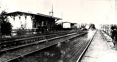
.jpg.webp) Princeton Junction train station | |
 Location in Mercer County and the state of New Jersey. | |
| Coordinates: 40.323294°N 74.621157°W | |
| Country | |
| State | |
| County | Mercer |
| Township | West Windsor |
| Area | |
| • Total | 1.853 sq mi (4.801 km2) |
| • Land | 1.826 sq mi (4.730 km2) |
| • Water | 0.027 sq mi (0.071 km2) 1.48% |
| Elevation | 60 ft (22 m) |
| Population | |
| • Total | 2,465 |
| • Density | 1,349.8/sq mi (521.2/km2) |
| Time zone | UTC-5 (Eastern (EST)) |
| • Summer (DST) | UTC-4 (Eastern (EDT)) |
| ZIP code | 08550[4] |
| Area code(s) | 609 |
| FIPS code | 3460960[1][5] |
| GNIS feature ID | 02389708[1][6] |
History
Following the mid-1860s relocation of the Camden & Amboy rail line from next to the Delaware & Raritan Canal to the present location of the Northeast Corridor, and the subsequent construction of a train station south of the intersection of Washington Road and the new rail line, a community called "Princeton Junction" developed. This community originally featured several farmhouses, a hotel, a general store, a feed mill, and several other businesses centered around the intersection of Station Drive & Washington Road, profiting off of access to other cities provided by the rail line.[9]
The construction of the neighborhood of Berrien City (focused around Scott Avenue, Alexander Road, and Berrien Avenue) represented West Windsor's first planned development. Following the reconstruction of the Washington Road railroad bridge in 1939, the business center of the community shifted to the intersection of Washington Road and Cranbury Road, where a lumber yard, service station, liquor store, strip mall, several gas stations, and several more businesses operated for decades.[9]
Following World War II,, the Princeton Junction population grew with the construction of residential developments such as Sherbrooke Estates, Windsor Chase, and Wellington Estates.[9]
Princeton Junction is currently the proposed site of a "Transit Village" to be built northwest of the train station.[9]
In October 2019, the Historical Society of West Windsor published an online museum exploring the history of West Windsor - including that of Princeton Junction.[9]
Geography

According to the United States Census Bureau, the CDP had a total area of 1.853 square miles (4.801 km2), including 1.826 square miles (4.730 km2) of land and 0.027 square miles (0.071 km2) of water (1.48%).[1][10]
Princeton Junction's name comes from the train station of the same name, now on the Amtrak and New Jersey Transit Northeast Corridor. The station is the junction between this main line and a spur served by the "Dinky" train, run by New Jersey Transit, to Princeton itself.
Demographics
| Historical population | |||
|---|---|---|---|
| Census | Pop. | %± | |
| 1990 | 2,362 | — | |
| 2000 | 2,382 | 0.8% | |
| 2010 | 2,465 | 3.5% | |
| Population sources: 2000[11] 2010[3] | |||
Census 2010
The 2010 United States Census counted 2,465 people, 921 households, and 696 families in the CDP. The population density was 1,349.8 per square mile (521.2/km2). There were 940 housing units at an average density of 514.7 per square mile (198.7/km2). The racial makeup was 74.81% (1,844) White, 2.43% (60) Black or African American, 0.16% (4) Native American, 18.62% (459) Asian, 0.00% (0) Pacific Islander, 1.42% (35) from other races, and 2.56% (63) from two or more races. Hispanic or Latino of any race were 5.44% (134) of the population.[3]
Of the 921 households, 35.0% had children under the age of 18; 68.6% were married couples living together; 5.4% had a female householder with no husband present and 24.4% were non-families. Of all households, 20.8% were made up of individuals and 11.5% had someone living alone who was 65 years of age or older. The average household size was 2.66 and the average family size was 3.08.[3]
25.0% of the population were under the age of 18, 4.6% from 18 to 24, 23.0% from 25 to 44, 30.6% from 45 to 64, and 16.8% who were 65 years of age or older. The median age was 43.3 years. For every 100 females, the population had 95.3 males. For every 100 females ages 18 and older there were 90.2 males.[3]
Census 2000
As of the 2000 United States Census[5] there were 2,382 people, 842 households, and 681 families living in the CDP. The population density was 491.8/km2 (1,276.9/mi2). There were 858 housing units at an average density of 177.2/km2 (460.0/mi2). The racial makeup of the CDP was 86.99% White, 2.02% African American, 0.13% Native American, 8.86% Asian, 0.76% from other races, and 1.26% from two or more races. Hispanic or Latino of any race were 3.06% of the population.[11]
There were 842 households, out of which 41.7% had children under the age of 18 living with them, 71.0% were married couples living together, 7.4% had a female householder with no husband present, and 19.1% were non-families. 15.6% of all households were made up of individuals, and 5.8% had someone living alone who was 65 years of age or older. The average household size was 2.82 and the average family size was 3.14.[11]
In the CDP the population was spread out, with 28.3% under the age of 18, 4.0% from 18 to 24, 27.8% from 25 to 44, 28.9% from 45 to 64, and 11.0% who were 65 years of age or older. The median age was 40 years. For every 100 females, there were 99.2 males. For every 100 females age 18 and over, there were 98.4 males.[11]
The median income for a household in the CDP was $116,668, and the median income for a family was $127,617. Males had a median income of $100,000 versus $58,750 for females. The per capita income for the CDP was $44,113. None of the families and 1.5% of the population were living below the poverty line, including no under eighteens and 5.3% of those over 64.[11]
Business and industry
At the turn of the century two of Princeton Junction's landmark retailers closed. One was Lick-It ice cream, a tiny kiosk-like yellow building that served ice cream to walk-in and drive-through customers, always including a trademark nonpareil in the ice cream. Also, the family-owned Lucar Hardware store shut down due to competition with superstores like Home Depot and Lowe's Hardware. Competition was not the only factor, however. The owners sought to retire, and the land had become more valuable. The site is now occupied by PNC Bank.
In 2008-2009, Princeton Junction saw the further closure of a number of businesses that had been longtime fixtures. Among the most significant is the closure of an Acme Supermarket, which had been an anchor tenant in the Windsor Plaza Shopping Center for 50 years. Other closures (of Chicken Holiday fast food shop, a paint store and an Asian restaurant) were prompted to make way for the construction of a new Rite Aid store.
Some residents blame the 'deterioration' of the central Princeton Junction area on a lack of political consensus.[12]
Notable people
People who were born in, residents of, or otherwise closely associated with Princeton Junction include:
- Kevin Barry (born 1978), baseball player.
- Douglas Forrester (born 1953), former gubernatorial candidate.
- Ethan Hawke (born 1970), actor.[13]
- Matt Lalli (born 1986), professional lacrosse player for the Boston Cannons of Major League Lacrosse.[14]
- Ben H. Love (1930–2010), eighth Chief Scout Executive of the Boy Scouts of America serving from 1985 to 1993.[15]
- James Murphy (born 1970), DJ, electronic musician (as LCD Soundsystem).[16]
- John Forbes Nash, Jr. (1928–2015), mathematician.[17]
- Bryan Singer (born 1965), film director, writer and producer.[18][19]
- Note
- Christopher McQuarrie (born 1968), screenwriter, was born either in Princeton Junction, where he was raised, or in nearby Princeton. Different sources — and in the case of All Movie Guide, the same source — give both places. Note that Princeton Junction has no hospital.[20][21]
References
- Gazetteer of New Jersey Places, United States Census Bureau. Accessed July 21, 2016.
- U.S. Geological Survey Geographic Names Information System: Princeton Junction Census Designated Place, Geographic Names Information System. Accessed November 21, 2012.
- DP-1 - Profile of General Population and Housing Characteristics: 2010 Demographic Profile Data for Princeton Junction CDP, New Jersey Archived 2020-02-12 at Archive.today, United States Census Bureau. Accessed November 20, 2012.
- Look Up a ZIP Code for Hamilton Square, NJ, United States Postal Service. Accessed November 21, 2012.
- U.S. Census website , United States Census Bureau. Accessed September 4, 2014.
- US Board on Geographic Names, United States Geological Survey. Accessed September 4, 2014.
- New Jersey: 2010 - Population and Housing Unit Counts - 2010 Census of Population and Housing (CPH-2-32), United States Census Bureau, August 2012. Accessed November 20, 2012.
- Locality Search, State of New Jersey. Accessed April 19, 2015.
- "Princeton Junction". THE SCHENCK FARMSTEAD. Retrieved 2020-09-29.
- US Gazetteer files: 2010, 2000, and 1990, United States Census Bureau. Accessed September 4, 2014.
- DP-1 - Profile of General Demographic Characteristics: 2000 from the Census 2000 Summary File 1 (SF 1) 100-Percent Data for Princeton Junction CDP, New Jersey Archived 2020-02-12 at Archive.today, United States Census Bureau. Accessed November 20, 2012.
- "WW's Problem: Lots of Talk, Little Action". West Windsor & Plainsboro News. October 23, 2009. Retrieved September 10, 2015.
- Spiegel, Phyllis. "The Sun Rises on Ethan Hawke", U.S. 1, July 5, 2006. Accessed July 22, 2016. "Now 36, Ethan Hawke, who grew up in Princeton Junction, is an Academy Award-nominated movie star, a director, the author of two novels, and he has appeared in several major stage productions."
- Matt Lalli, Colgate Raiders men's lacrosse. Accessed September 21, 2015. "Hometown: Princeton Junction, N.J. High School: West Windsor Plainsboro... Born on March 27, 1986 in Princeton, N.J."
- Staff. "Jersey Man to Head Scouts", The New York Times, October 21, 1984. Accessed November 21, 2012. "Mr. Love, who is 54 years old and lives in Princeton Junction, N.J., has headed the organization's Northeast region, based in Dayton, N.J."
- "LCD Soundsystem's James Murphy on Bringing Back New York's Disco Days -- New York Magazine"
- Blakinger, Mary. "After 30 Years, He Beat A Disease Winner Of Nobel Prize Has Another Amazing Feat.", The Philadelphia Inquirer, October 9, 2000. Accessed November 21, 2012. "These days, Nash, who lives in Princeton Junction, is a senior research mathematician at Princeton University."
- Weinraub, Bernard. "FILM; An Unusual Choice for the Role of Studio Superhero", The New York Times, July 9, 2000. Accessed November 21, 2012. "As a child, Mr. Singer grew up in Princeton Junction, N.J."
- Longsdorf, Amy. "`SUSPECTS' DIRECTOR TWISTS THE TWIST", The Morning Call, September 10, 1995. Accessed November 21, 2012. "Though "Suspects" is set in New York and Los Angeles, Singer is a Jersey boy through and through. He grew up in Princeton Junction, the adopted son of an environmental activist mom and Maidenform exec dad."
- Buchanan, Jason. "Christopher McQuarrie". All Movie Guide / Rovi via The New York Times. Archived from the original on July 14, 2015. Retrieved November 21, 2012.
Birthplace: Princeton, New Jersey, USA ... Born in Princeton Junction, NJ, in 1968...
- "Christopher McQuarrie". Turner Classic Movies. Archived from the original on July 14, 2015. Retrieved July 14, 2015.
Birth Place: Princeton, New Jersey, USA
| Wikimedia Commons has media related to Princeton Junction, New Jersey. |
