Pulilan Regional Road
The Pulilan Regional Road (also known as Pulilan–Calumpit Road) is an 10.95-kilometer (6.80 mi), two-lane national highway that connects the municipalities of Calumpit and Pulilan in Bulacan.[1] It forms part of National Route 115 (N115) of the Philippine highway network.
| ||||
|---|---|---|---|---|
| Pulilan–Calumpit Road | ||||
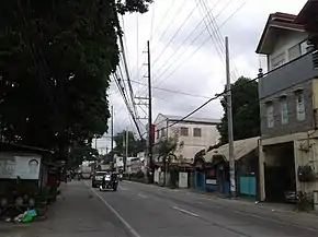 Pulilan Regional Road in Barangay Paltao, Pulilan | ||||
| Route information | ||||
| Maintained by Department of Public Works and Highways (Bulacan 1st District Engineering Office) | ||||
| Length | 11.0 km (6.8 mi) | |||
| Component highways | ||||
| Major junctions | ||||
| West end | ||||
| East end | ||||
| Location | ||||
| Provinces | Bulacan | |||
| Towns | Calumpit, Pulilan | |||
| Highway system | ||||
| ||||
.svg.png.webp)
Route description

The Pulilan Regional Road starts at Caltex in Calumpit and passes through residential areas and establishments of Calumpit and Pulilan. A few meters after it is the Bagbag Bridge. It continues on a straight path until it enters Pulilan through its welcome sign and intersects with the North Luzon Expressway (NLEX). The segment between Caltex and Pulilan Exit was formerly lined by 30 steel poles (284–313) of Hermosa–Duhat–Balintawak transmission line from June 1994 until the relocation of its San Simon–Pulilan section along NLEX in March 2011. After passing NLEX is Barangay Tibag, where a branch of Nestle is located. The road turns eastward, passes through Barangays Dampol I, Lumbac, Poblacion, Paltao, and Cutcot and ends on Pan-Philippine Highway.
References
| Expressways |
| ||||||
|---|---|---|---|---|---|---|---|
| National roads |
| ||||||