Pan-Philippine Highway
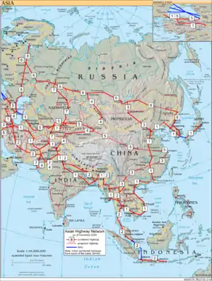
The Pan-Philippine Highway, also known as the Maharlika Highway (Tagalog: Daang Maharlika; Cebuano: Dalang Halangdon) is a 3,517-kilometer (2,185 mi) network of roads, expressways, bridges, and ferry services that connect the islands of Luzon, Samar, Leyte, and Mindanao in the Philippines, serving as the country's principal transport backbone. It is the longest highway in the Philippines that forms the country's north–south backbone component of the National Route 1 (N1) of the Philippine highway network. The entire highway is designated as Asian Highway 26 (AH26) of the Asian Highway Network.[1]
| ||||
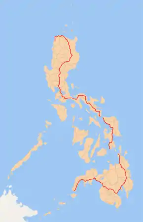 Map of the Philippines showing the route of Pan-Philippine Highway | ||||
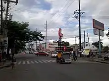
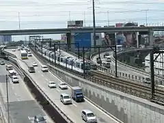
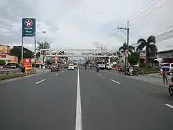 The segment of the highway in Santo Tomas, Batangas | ||||
| Route information | ||||
| Maintained by the Department of Public Works and Highways (DPWH) | ||||
| Length | 3,517 km[1] (2,185 mi) | |||
| Existed | 1960s–present | |||
| Major junctions | ||||
| North end | Laoag, Ilocos Norte, Philippines | |||
| South end | Zamboanga City, Philippines | |||
| Location | ||||
| Provinces |
| |||
| Highway system | ||||
| ||||
The northern terminus of the highway is in Laoag and the southern terminus is in Zamboanga City.[1]
Development
The highway was proposed in 1965, and built under the administration of President Ferdinand Marcos. Government planners believed that the motorway and other connected roads would stimulate agricultural production by reducing transport costs, encourage social and economic development outside existing major urban centers such as Manila, and expand industrial production for domestic and overseas markets. Construction was supported by loans and grants from foreign aid institutions, including the World Bank.
The highway was rehabilitated and improved in 1997, during the administration of President Fidel Ramos, with assistance from the Japanese government, and dubbed the "Philippine-Japan Friendship Highway". In 1998, the Department of Tourism designated 35 sections of the highway as "Scenic Highways", with developed amenities for travelers and tourists.
In March 2018, Public Works and Highways Secretary Mark Villar inaugurated the 24.61-kilometer (15.29 mi) arterial road that will link the North Luzon Expressway (NLEX) with the Maharlika Highway that traverses the central part of Luzon.[2]
Asian Highway Network
The Pan-Philippine Highway is designated as AH26 in the Asian Highway Network, a cooperative project which seeks to improve highway systems and standards across the continent. It is currently the only highway in the system that is isolated from every other highway; island-based sections of the Asian Highway Network in Japan (AH1), Sri Lanka (AH43) and Indonesia (AH2) are all linked to the mainland sections by ferries to South Korea (AH1), India (Dhanushkodi), and Singapore, respectively.
Associated Routes
_(EDSA-North_Triangle%252C_Quezon_City%253B_2017-02-22).jpg.webp)
_marker_(South_Superhighway%252C_Muntinlupa)(2017-05-25).jpg.webp)
AH26 runs along the following thoroughfares:[3]
.svg.png.webp) Manila North Road/Maharlika Highway: Laoag[lower-alpha 1][lower-alpha 2] – Aparri
Manila North Road/Maharlika Highway: Laoag[lower-alpha 1][lower-alpha 2] – Aparri- Bangag-Magapit Road: Aparri – Lal-lo[lower-alpha 3]
- Cagayan Valley Road: Lal-lo – Tuguegarao
- Maharlika Highway:[lower-alpha 4][lower-alpha 5] San Pablo – Ilagan – Santiago – Solano[lower-alpha 6] – Bayombong – San Jose City – Cabanatuan – Gapan – San Miguel – Baliuag – Pulilan – Guiguinto
.svg.png.webp) North Luzon Expressway: Santa Rita Interchange, Guiguinto – Balintawak Interchange, Quezon City (partially signed as AH26)
North Luzon Expressway: Santa Rita Interchange, Guiguinto – Balintawak Interchange, Quezon City (partially signed as AH26)- EDSA (Eastern Route): Balintawak Interchange, Quezon City – Magallanes Interchange, Makati (around Metro Manila)
.svg.png.webp) South Luzon Expressway: Magallanes Interchange, Makati – Calamba Exit, Calamba (partially signed as AH26)
South Luzon Expressway: Magallanes Interchange, Makati – Calamba Exit, Calamba (partially signed as AH26)
- Maharlika Highway: Calamba – Santo Tomas – San Pablo – Tiaong[lower-alpha 7] – Candelaria[lower-alpha 8] – Sariaya[lower-alpha 9] – Lucena
- Lucena Diversion Road: Lucena – Pagbilao
- Maharlika Highway: Pagbilao[lower-alpha 10] – Gumaca[lower-alpha 6][lower-alpha 11] - Calauag[lower-alpha 12] – Daet – Milaor[lower-alpha 13] – Naga City[lower-alpha 14] – Daraga – Sorsogon City[lower-alpha 15] – Matnog
 Matnog–Allen ferry line: Luzon – Visayas (via San Bernardino Strait)
- Maharlika Highway: Allen – Calbayog[lower-alpha 16] – Catbalogan[lower-alpha 17] – Tacloban – Palo – Mahaplag – Liloan
- Liloan–Lipata ferry line: Visayas – Mindanao (via Bohol Sea)
- Maharlika Highway: Surigao City – Kitcharao
- Surigao-Butuan National Highway: Kitcharao – Butuan
- Davao-Agusan National Highway: Butuan – Bayugan – Tagum – Davao City[lower-alpha 18]
- C.M. Recto Avenue: Davao City (one-way street)
- A. Pichon Street: Davao City (one-way street)
- Elpidio Quirino Avenue: Davao City
- MacArthur Highway: Davao City
- Davao-Cotabato Road: Davao City – Digos
- Digos-Makar Road: Digos[lower-alpha 8] – Malungon – General Santos
- Marbel-Makar Road: General Santos – Koronadal
- Cotabato-Marbel Road: Koronadal – Surallah
- Isulan-Surallah Road: Surallah – Norala
- Isulan-Surallah Road: Isulan[lower-alpha 19]
- Marbel-Allah Valley-Cotabato Road: Isulan – Datu Odin Sinsuat
- Marbel-Allah Valley-Cotabato Road: Cotabato City[lower-alpha 20]
- Narciso Ramos Highway: Sultan Kudarat – Parang – Balabagan
- Rizal Avenue: Balabagan – Malabang – Picong
- Maharlika Highway: Sultan Naga Dimaporo – Tukuran[lower-alpha 8][lower-alpha 21] – Pagadian[lower-alpha 1][lower-alpha 21] – Ipil – Tungawan – Zamboanga City[lower-alpha 22]
Auxiliary Routes
Alternatively, AH26 runs along the following thoroughfares:[3]
- Luzon
- EDSA (Western Route): Balintawak Interchange, Quezon City – Caloocan
.svg.png.webp) Samson Road: Caloocan
Samson Road: Caloocan- Gen. San Miguel Street: Caloocan
- C-4 Road: Caloocan – Malabon – Navotas
- R-10: Navotas
- Mel Lopez Boulevard: Manila
- Bonifacio Drive: Manila
- Roxas Boulevard: Manila – Pasay
- EDSA (Western Route): Pasay – Magallanes Interchange, Makati
- Visayas
.svg.png.webp) Palo–Carigara–Ormoc Road:[lower-alpha 23] Palo – Ormoc[lower-alpha 24]
Palo–Carigara–Ormoc Road:[lower-alpha 23] Palo – Ormoc[lower-alpha 24]- Ormoc–Baybay–Southern Leyte Boundary Road:[lower-alpha 23] Ormoc – Albuera[lower-alpha 25] – Baybay[lower-alpha 26]
- Tacloban–Baybay South Road: Baybay – Mahaplag
- Mindanao
Intersections
- Ilocos Norte
.svg.png.webp) N2 in Laoag (northern terminus of AH26)
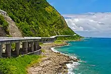
N2 in Laoag (northern terminus of AH26)- Patapat Viaduct
- Cagayan
.svg.png.webp) N223 in Abulug
N223 in Abulug- Magapit Suspension Bridge
.svg.png.webp)
 N101 / N119 in Magapit Interchange, Lal-lo
N101 / N119 in Magapit Interchange, Lal-lo.svg.png.webp) N104 in Tuguegarao
N104 in Tuguegarao.svg.png.webp)
 N105 in Tuguegarao
.svg.png.webp)
 N51 / N106 in Tuguegarao
N51 / N106 in Tuguegarao- N104 in Tuguegarao
- Isabela
- Nueva Vizcaya
- Nueva Ecija
.svg.png.webp)
 N56 / N111 in San Jose
N56 / N111 in San Jose.svg.png.webp) N113 in Santo Domingo
N113 in Santo Domingo.svg.png.webp) N114 in Santo Domingo
N114 in Santo Domingo- N111 in Cabanatuan
.svg.png.webp) N58 in Santa Rosa
N58 in Santa Rosa.svg.png.webp) N3 in Gapan
N3 in Gapan
- Bulacan
- Metro Manila
.svg.png.webp) N118 in Valenzuela
N118 in Valenzuela.svg.png.webp) E5 in Valenzuela
E5 in Valenzuela.svg.png.webp) N127 in Unang Sigaw, Quezon City
N127 in Unang Sigaw, Quezon City.svg.png.webp) N1 / N160 in Balintawak, Quezon City
N1 / N160 in Balintawak, Quezon City- N127 in Unang Sigaw, Quezon City
.svg.png.webp) N129 in Muñoz, Quezon City
N129 in Muñoz, Quezon City.svg.png.webp)
 N171 / N173 in Diliman, Quezon City
N171 / N173 in Diliman, Quezon City.svg.png.webp) N170 in Diliman, Quezon City
N170 in Diliman, Quezon City.svg.png.webp)
 N172 / N174 in Diliman, Quezon City
N172 / N174 in Diliman, Quezon City.svg.png.webp)
 N180 / N59 in Cubao, Quezon City
N180 / N59 in Cubao, Quezon City.svg.png.webp) N185 near Camp Aguinaldo, Quezon City
N185 near Camp Aguinaldo, Quezon City.svg.png.webp)
 N184 / N60 in Quezon City and Mandaluyong
N184 / N60 in Quezon City and Mandaluyong.svg.png.webp) N141 in Mandaluyong
N141 in Mandaluyong- Guadalupe Bridge
.svg.png.webp) N190 in Makati
N190 in Makati.svg.png.webp) N191 in Makati
N191 in Makati- N190 in Makati
.svg.png.webp) N1 / N145 in Magallanes, Makati
N1 / N145 in Magallanes, Makati.svg.png.webp) E6 in Taguig
E6 in Taguig.svg.png.webp) N11 in Taguig
N11 in Taguig.svg.png.webp) N63 in Parañaque and Muntinlupa
N63 in Parañaque and Muntinlupa- N1 in Alabang, Muntinlupa
- E2 in Tunasan, Muntinlupa
- Cavite
- Laguna (2nd segment)
.svg.png.webp) N420 in Santa Rosa
N420 in Santa Rosa- E2 / N1 in Calamba
- Batangas
- E2 in Santo Tomas
.svg.png.webp) N4 in Santo Tomas
N4 in Santo Tomas
- Laguna (3rd segment)
- Quezon
.svg.png.webp) N608 in Tiaong (northern terminus)
N608 in Tiaong (northern terminus).svg.png.webp) N435 in Tiaong
N435 in Tiaong- N608 in Tiaong (southern terminus)
.svg.png.webp) N609 in Candelaria (western & eastern termini)
N609 in Candelaria (western & eastern termini).svg.png.webp) N606 in Isabang, Lucena
N606 in Isabang, Lucena.svg.png.webp) N422 in Isabang, Lucena
N422 in Isabang, Lucena.svg.png.webp) N603 in Gulang-Gulang, Lucena
N603 in Gulang-Gulang, Lucena- N606 in Talipan, Pagbilao
.svg.png.webp) N610 in Padre Burgos
N610 in Padre Burgos.svg.png.webp) N613 in Gumaca
N613 in Gumaca.svg.png.webp) N612 in Lopez
N612 in Lopez.svg.png.webp) N657 in Lopez
N657 in Lopez
- Camarines Norte
.svg.png.webp) N68 in Santa Elena
N68 in Santa Elena.svg.png.webp) N620 in Labo
N620 in Labo.svg.png.webp) N621 in Daet (northern & southern termini)
N621 in Daet (northern & southern termini)
- Camarines Sur
- N68 in Sipocot
.svg.png.webp) N623 in Pamplona
N623 in Pamplona.svg.png.webp) N672 in Pili
N672 in Pili.svg.png.webp) N673 in Pili
N673 in Pili.svg.png.webp) N630 in Pili
N630 in Pili.svg.png.webp) N634 in Baao
N634 in Baao- N634 in Nabua
.svg.png.webp) N635 in Bato
N635 in Bato
- Albay
- Sorsogon
.svg.png.webp) N642 in Pilar
N642 in Pilar.svg.png.webp) N641 in Castilla
N641 in Castilla.svg.png.webp) N643 in Sorsogon City (western terminus)
N643 in Sorsogon City (western terminus).svg.png.webp) N644 in Sorsogon City
N644 in Sorsogon City- N643 in Sorsogon City (eastern terminus)
.svg.png.webp) N645 in Bulan
N645 in Bulan
- Northern Samar
.svg.png.webp) N670 in Allen
N670 in Allen
- Samar
- N672 in Calbayog
- N673 in Calbayog
.svg.png.webp) N677 in Gandara (northern & southern termini)
N677 in Gandara (northern & southern termini).svg.png.webp) N675 in Catbalogan
N675 in Catbalogan.svg.png.webp) N674 in Paranas
N674 in Paranas- N670 in Basey
- N670 in Santa Rita
- Samar–Leyte boundary
- Leyte
- Southern Leyte
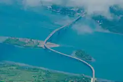
- Agas-Agas Bridge
.svg.png.webp) N692 in Sogod
N692 in Sogod.svg.png.webp) N690 in Liloan
N690 in Liloan.svg.png.webp) N691 in Liloan
N691 in Liloan- Wawa Bridge
- Surigao del Norte
.svg.png.webp) N901 in Surigao City
N901 in Surigao City.svg.png.webp) N902 in Placer
N902 in Placer
- Agusan del Norte
- Agusan del Sur
.svg.png.webp) N903 in Prosperidad
N903 in Prosperidad.svg.png.webp) N904 in Prosperidad
N904 in Prosperidad.svg.png.webp) N905 in San Francisco
N905 in San Francisco.svg.png.webp) N904 / N73 in Trento
N904 / N73 in Trento
- Davao de Oro
.svg.png.webp) N906 in Montevista
N906 in Montevista.svg.png.webp) N907 in Nabunturan
N907 in Nabunturan
- Davao del Norte
.svg.png.webp) N908 in Tagum (northern terminus)
N908 in Tagum (northern terminus).svg.png.webp)
 N909 / N74 in Tagum
N909 / N74 in Tagum- N908 in Tagum (southern terminus)
.svg.png.webp) N910 in Carmen
N910 in Carmen- N909 in Panabo
- Davao Del Sur
.svg.png.webp) N913 in Buhawan, Davao City (eastern terminus)
N913 in Buhawan, Davao City (eastern terminus).svg.png.webp) N915 in Buhangin, Davao City
N915 in Buhangin, Davao City.svg.png.webp) N916 in Agdao, Davao City (eastern terminus)
N916 in Agdao, Davao City (eastern terminus).svg.png.webp) N917 in Agdao, Davao City
N917 in Agdao, Davao City.svg.png.webp) N918 in Agdao & Buhangin, Davao City
N918 in Agdao & Buhangin, Davao City.svg.png.webp)
 N919 / N920 in Poblacion, Davao City
N919 / N920 in Poblacion, Davao City- N919 in Poblacion, Davao City
- N920 in Poblacion, Davao City
.svg.png.webp) N921 in Talomo, Davao City
N921 in Talomo, Davao City- N916 in Talomo, Davao City (western terminus)
- N913 in Talomo, Davao City (western terminus)
.svg.png.webp) N10 in Talomo, Davao City
N10 in Talomo, Davao City.svg.png.webp) N923 in Digos (northern terminus)
N923 in Digos (northern terminus).svg.png.webp) N75 in Digos
N75 in Digos.svg.png.webp) N924 in Digos
N924 in Digos- N923 in Digos (southern terminus)
.svg.png.webp) N930 in Sulop
N930 in Sulop
- South Cotabato
.svg.png.webp) N931 in General Santos (eastern terminus)
N931 in General Santos (eastern terminus)- N930 in General Santos
.svg.png.webp) N935 in General Santos
N935 in General Santos- N931 in General Santos
- Sultan Kudarat
- Maguindanao
- Lanao del Sur
- Zamboanga del Sur
- Zamboanga Sibugay
- Zamboanga City
.svg.png.webp) N968
N968.svg.png.webp)
.svg.png.webp)
 N966 / N970 / N971 (southern terminus of AH26)
N966 / N970 / N971 (southern terminus of AH26)
Auxiliary routes
.jpg.webp)
- N1 / N160 in Balintawak, Quezon City
.svg.png.webp) N1 / N150 in Caloocan
N1 / N150 in Caloocan.svg.png.webp) N130 in Navotas
N130 in Navotas- E5 in Navotas
.svg.png.webp) N140 in Tondo, Manila
N140 in Tondo, Manila- N145 in Tondo and San Nicolas, Manila
- N150 in Ermita and Intramuros, Manila
.svg.png.webp) N155 in Ermita, Manila
N155 in Ermita, Manila.svg.png.webp) N156 in Ermita, Manila
N156 in Ermita, Manila- N140 in Malate, Manila
- N190 in Pasay
.svg.png.webp) N61 in Pasay
N61 in Pasay- N170 in Pasay
- N171 in Pasay
- N145 / E2 in Magallanes, Makati
- Visayas (western route) – part of N70
- Mindanao – part of N10
- N1 in Davao City
.svg.png.webp) N942 in Arakan
N942 in Arakan.svg.png.webp) N943 in Maramag
N943 in Maramag.svg.png.webp) N912 in Valencia
N912 in Valencia.svg.png.webp) N9 in Cagayan de Oro
N9 in Cagayan de Oro
See also
Notes
Pan-Philippine Highway also has alternative names, especially locally within the poblacion of respective town and cities.
- A segment of Pan-Philippine Highway in Laoag and Pagadian is locally known as J.P. Rizal Avenue, respectively.
- A segment of Pan-Philippine Highway stretching north out of Laoag is known as Gen. Segundo Avenue.
- A segment of Bangag-Magapit Road is also known as Logac-Magapit Road in Lal-lo, Cagayan.
- The segment of Maharlika Highway from Isabela to Bulacan is also known as Cagayan Valley Road.
- Pan-Philippine Highway is also known as Doña Remedios Trinidad Highway from San Rafael to Pulilan in Bulacan, bypassing the respective municipal centers of Baliuag and Bustos.
- A segment of Pan-Philippine Highway at the town proper is locally known as J.P. Rizal Street.
- A segment of Pan-Philippine Highway at the town proper of Tiaong, Quezon is locally known as Doña Tating Street and Don V. Robles Street, respectively.
- A segment of Pan-Philippine Highway at the town proper is locally known as Rizal Avenue.
- A segment of Pan-Philippine Highway at the town proper of Sariaya, Quezon is locally known as General Luna Street.
- A segment of Pan-Philippine Highway at the town proper of Pagbilao, Quezon is locally known as Recto Street and Figueroa Street, respectively.
- A segment of Pan-Philippine Highway at the town proper of Gumaca, Quezon is locally known as Bonifacio Street.
- An alternative route to Pan-Philippine Highway is the Highway 68 or Quirino Highway that will bypass Camarines Norte entirely and will shorten the route by four hours.
- A segment of Pan-Philippine Highway at the town proper of Milaor, Camarines Sur is locally known as Mabolo Road.
- A segment of Pan-Philippine Highway at the city proper of Naga, Camarines Sur is locally known as Roxas Avenue.
- A segment of Pan-Philippine Highway at the city proper of Sorsogon City is locally known as Rizal Street and Magsaysay Avenue, respectively
- A segment of Pan-Philippine Highway at the city proper of Calbayog, Samar is locally known as Jose D. Avelino Street.
- A segment of Pan-Philippine Highway at the city proper of Catbalogan, Samar is locally known as Del Rosario Street, Curry Avenue, San Roque Street, and Rizal Avenue Extension, respectively.
- The segment of Davao-Agusan National Highway from Lanang towards the city proper of Davao City is also known as J.P. Laurel Avenue.
- A segment of Isulan-Surallah Road in Isulan is locally known as Sen. Ninoy Aquino Avenue.
- A segment of Marbel-Allah Valley-Cotabato Road at the city proper of Cotabato City is locally known as Sinsuat Avenue and Quezon Avenue, respectively.
- A segment of Pan-Philippine Highway here is locally known as National Highway.
- A segment of Pan-Philippine Highway in Zamboanga City is locally known as Maria Clara L. Lobregat Highway, Veterans Avenue, Governor Lim Avenue, and Don Pablo Lorenzo Street, respectively.
- Alternative name varies, according to its segments between towns/cities. For example, Palo–Carigara–Ormoc Road is also known as Palo–Santa Fe Road from Palo to Santa Fe, Leyte.
- A segment of Palo–Carigara–Ormoc Road at the town proper of Ormoc is locally known as Real Street and Aviles Street, respectively.
- Ormoc–Baybay–Southern Leyte Boundary Road at the town proper of Albuera, Leyte is locally known as Lawis Street and Rizal Street, respectively.
- A segment of Ormoc–Baybay–Southern Leyte Boundary Road at the town proper of Baybay, Leyte is locally known as Apolinario Mabini Street and Ramon Magsaysay Avenue, respectively.
References
- "Department Order No. 15, Series of 2009" (PDF). Department of Public Works and Highways. 27 February 2015. Archived from the original (PDF) on 27 February 2015. Retrieved 24 March 2009.
- "North Luzon expressway, Maharlika highway linked". Manila Bulletin. Retrieved October 9, 2018.
- "Road and Bridge Inventory". Department of Public Works and Highways. Retrieved June 16, 2020.
External links
| Wikimedia Commons has media related to Pan-Philippine Highway. |
| Wikivoyage has a travel guide for Asian Highway 26. |
| ||||||||||||||||||||||||||||||||||||||||||||||||||||||||||||||||||||||||||||||||||||||||||||||||||||||||||||||||||||||||||||||||||||||||||||||||||