Pyin Oo Lwin District
Pyin Oo Lwin District (Burmese: ပြင်ဦးလွင်ခရိုင်; MLCTS: ) is a district of the Mandalay Region in central Burma. It lies northeast of Mandalay, with the Myitnge River as its southern boundary.[1] To the east it is bordered by Shan State and in part by the Chaung Magyi (Chaung means stream). It goes north as far as the town of Dakaung where it adjoins Htigyaing Township, Katha District in Sagaing Region. Its western boundary, is for the most part the Irrawaddy, but a very small portion of Thabeikkyin Township is west of the Irrawaddy, near the town of Baw in Sagaing Region. To the southwest it borders Mandalay District.[1]
Pyin Oo Lwin District
ပြင်ဦးလွင်ခရိုင် Maymyo, Meimyu, Pyin U Lwin, Pyinoolwin | |
|---|---|
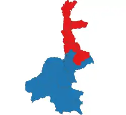 Location in Mandalay region | |
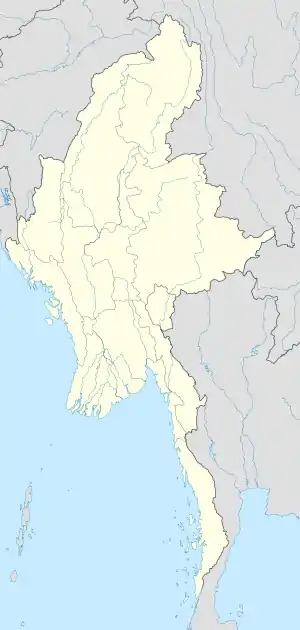 Location in Myanmar | |
| Coordinates: 22°02′N 96°27′E | |
| Country | |
| Region | Mandalay |
| No. of Townships | 5 |
| Capital | Pyin U Lwin (Maymyo) |
| Time zone | UTC+6.30 (MST) |
Townships
Notes
- Map of Mandalay Division Myanmars.net
- "Myanmar States/Divisions & Townships Overview Map" Myanmar Information Management Unit (MIMU)
Capital: Mandalay | ||
| Kyaukse District |   | |
| Mandalay District | ||
| Meiktila District | ||
| Myingyan District | ||
| Nyaung-U District |
| |
| Pyinoolwin District | ||
| Yamethin District | ||
| Main cities and towns | ||
This article is issued from Wikipedia. The text is licensed under Creative Commons - Attribution - Sharealike. Additional terms may apply for the media files.