Quebec Route 289
Route 289 is a two-lane north/south highway on the south shore of the Saint Lawrence River in the Bas-Saint-Laurent region of eastern Quebec, Canada. Its northern terminus is in Saint-André at the junction of Route 132 and the southern terminus is at the border of New Brunswick where it continues as Route 120.
| ||||
|---|---|---|---|---|
 | ||||
| Route information | ||||
| Maintained by Transports Québec | ||||
| Length | 94.8 km[1] (58.9 mi) | |||
| Major junctions | ||||
| South end | ||||
| North end | ||||
| Location | ||||
| Major cities | Pohénégamook | |||
| Highway system | ||||
| ||||

Route 289 is also designated as the "route des Frontières" tourism highway.[2]
List of towns along Route 289
- Saint-Marc-du-Lac-Long
- Riviere-Bleue
- Pohénégamook
- Saint-Alexandre-de-Kamouraska
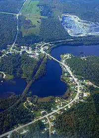 Route 289 meanders through Saint-Marc-du-Lac-Long.
.jpg.webp) Quebec Route 289 at Pohénégamook
Quebec Route 289 at Pohénégamook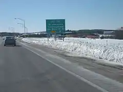 Interchange with Autoroute 20 in Saint-Alexandre.
See also
References
- Ministère des transports, "Distances routières", page 93, Les Publications du Québec, 2005
- "Corporation touristique de la Route des Frontières". Retrieved 2009-01-18.
External links
- Provincial Route Map (Courtesy of the Quebec Ministry of Transportation) (in French)
- Route 289 on Google Maps
This article is issued from Wikipedia. The text is licensed under Creative Commons - Attribution - Sharealike. Additional terms may apply for the media files.