Radibor
Radibor, in Sorbian Radwor, is a municipality in Saxony in Germany. It is situated in Upper Lusatia about 10 km north of Bautzen, which is also the main city of the District of Bautzen to which Radibor belongs.
Radibor/Radwor | |
|---|---|
 | |
Location of Radibor/Radwor within Bautzen district 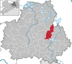 | |
 Radibor/Radwor  Radibor/Radwor | |
| Coordinates: 51°15′N 14°24′E | |
| Country | Germany |
| State | Saxony |
| District | Bautzen |
| Government | |
| • Mayor | Vinzenz Baberschke (CDU) |
| Area | |
| • Total | 61.93 km2 (23.91 sq mi) |
| Elevation | 165 m (541 ft) |
| Population (2019-12-31)[1] | |
| • Total | 3,119 |
| • Density | 50/km2 (130/sq mi) |
| Time zone | UTC+01:00 (CET) |
| • Summer (DST) | UTC+02:00 (CEST) |
| Postal codes | 02627 |
| Dialling codes | 035935 |
| Vehicle registration | BZ, BIW, HY, KM |
| Website | radibor.de |
Radibor was first mentioned in a written source in 1359. Its name is of Sorbian origin and generally means "place of the council". The municipality belongs to the central settlement area of the Sorbs.
Following villages belong to the municipality of Radibor:
- Bornitz (Boranecy), 125 inh.
- Brohna (Bronjo), 73 inh.
- Camina (Kamjenej), 119 inh.
- Cölln (Chelno), 356 inh.
- Droben (Droby), 89 inh.
- Großbrösern (Wulki Přezdrěń), 46 inh.
- Lippitsch (Lipič), 193 inh.
- Lomske (Łomsk), 205 inh.
- Luppa (Łupoj), 205 inh.
- Luppedubrau (Łupjanska Dubrawka), 79 inh.
- Luttowitz (Lutobč), 162 inh.
- Merka (Měrkow), 139 inh.
- Milkel (Minakał), 420 inh.
- Milkwitz (Miłkecy), 113 inh.
- Neu-Bornitz (Nowe Boranecy), 61 inh.
- Neu-Brohna (Nowe Bronjo), 20 inh.
- Quoos (Chasow), 156 inh.
- Radibor (Radwor), 704 inh.
- Schwarzadler (Čorny Hodler), 37 inh.
- Teicha (Hat), 75 inh.
- Wessel (Wjesel), 99 inh.
People
- Wolf Heinrich von Baudissin (1549-1646), Prussian field marshal during the Thirty Years' War
References
- "Bevölkerung des Freistaates Sachsen nach Gemeinden am 31. Dezember 2019". Statistisches Landesamt des Freistaates Sachsen (in German). July 2020.
| Authority control |
|---|
This article is issued from Wikipedia. The text is licensed under Creative Commons - Attribution - Sharealike. Additional terms may apply for the media files.