Ragged Top
Ragged Top is a 3,907-foot-elevation (1,191 m) mountain summit located within Ironwood Forest National Monument, in Pima County of southern Arizona.[3] It is situated 35 miles northwest of Tucson, in the Silver Bell Mountains, where it rises over 1,700 feet (520 m) above the surrounding terrain as a landmark of the area. Ragged Top is the biological and geological crown jewel of the monument for sightseeing and wildlife viewing, such as the Desert bighorn sheep and the desert tortoise. Ragged Top contains the greatest richness of species within the Sonoran Desert, including 401 plant species.[5] Cathestecum erectum (common name false grama) is only found on Ragged Top in the state of Arizona. Saguaro and ironwood forests cover the bajadas surrounding this mountain. This geographical feature lies within the Gila River drainage basin. Four small arches are located on this mountain.[6]
| Ragged Top | |
|---|---|
 Northeast aspect | |
| Highest point | |
| Elevation | 3,907 ft (1,191 m) [1] |
| Prominence | 1,347 ft (411 m) [1] |
| Parent peak | Silver Bell Benchmark[2] |
| Isolation | 2.40 mi (3.86 km) [2] |
| Coordinates | 32°26′58″N 111°29′24″W [3] |
| Geography | |
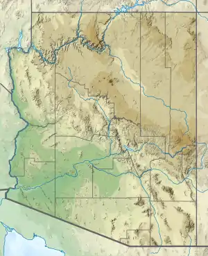 Ragged Top Location in Arizona  Ragged Top Ragged Top (the United States) | |
| Location | Ironwood Forest National Monument Pima County, Arizona, U.S. |
| Parent range | Silver Bell Mountains |
| Topo map | USGS Silver Bell East |
| Geology | |
| Age of rock | Cretaceous to Tertiary |
| Mountain type | volcanic plug[4] |
| Type of rock | Rhyolite |
| Climbing | |
| Easiest route | class 3 scrambling[2] |
Gallery

 West aspect
 North aspect
Climate
According to the Köppen climate classification system, Ragged Top is located in a hot arid climate zone.[7]
| Climate data for Silver Bell Mountains | |||||||||||||
|---|---|---|---|---|---|---|---|---|---|---|---|---|---|
| Month | Jan | Feb | Mar | Apr | May | Jun | Jul | Aug | Sep | Oct | Nov | Dec | Year |
| Average high °F (°C) | 63 (17) |
66 (19) |
71 (22) |
79 (26) |
88 (31) |
98 (37) |
98 (37) |
96 (36) |
93 (34) |
84 (29) |
72 (22) |
62 (17) |
81 (27) |
| Average low °F (°C) | 43 (6) |
46 (8) |
49 (9) |
55 (13) |
63 (17) |
72 (22) |
74 (23) |
72 (22) |
70 (21) |
61 (16) |
51 (11) |
43 (6) |
58 (14) |
| Average precipitation inches (mm) | 0.9 (23) |
0.9 (23) |
0.8 (20) |
0.2 (5.1) |
0.2 (5.1) |
0.3 (7.6) |
2.5 (64) |
2.5 (64) |
1.3 (33) |
1 (25) |
0.8 (20) |
1.3 (33) |
12.8 (330) |
| Source: Weatherbase [8] | |||||||||||||
References
- "Ragged Top, Arizona". Peakbagger.com. Retrieved 2020-12-15.
- "Ragged Top - 3,907' AZ". Lists of John. Retrieved December 15, 2020.
- "Ragged Top". Geographic Names Information System. United States Geological Survey. Retrieved December 15, 2020.
- Ironwood Forest National Monument Proposed Resource Management Plan and Final Environmental Impact Statement, US Department of the Interior Bureau of Land Management, September 2011.
- Ironwood Forest National Monument Proposed Resource Management Plan and Final Environmental Impact Statement, US Department of the Interior Bureau of Land Management, September 2011.
- Ironwood Forest National Monument Proposed Resource Management Plan and Final Environmental Impact Statement, US Department of the Interior Bureau of Land Management, September 2011.
- Peel, M. C.; Finlayson, B. L.; McMahon, T. A. (2007). "Updated world map of the Köppen−Geiger climate classification". Hydrol. Earth Syst. Sci. 11. ISSN 1027-5606.
- "Weatherbase.com". Weatherbase. 2013. Retrieved on July 30, 2013.
External links
| Wikimedia Commons has media related to Ragged Top. |
- Weather forecast: National Weather Service