Ramkot, Nepal
Ramkot is a village and former Village Development Committee that is now part of Nagarjun Municipality in Province No. 3 of central Nepal. At the time of the 1991 Nepal census it had a population of 5327 and had 972 households in it.[1] Ramkot is almost isolated area of Kathmandu when it comes to publicity. Ramkot was named to signify that Lord Ram was here during his exile.According to legends,Lord Ram left his coat here. Another legends defines the Lord Ram built a building to keep his weapons ( Kot- house of keeping weapons) Sitapaila, an attached VDC is named to show Lordess Sita, wife of Lord Ram was here too. Presently,there is one temple of goddess Sita which contains her footprints.
Ramkot
रामकोट | |
|---|---|
Village of Nagarjun Municipality | |
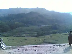 Paddy field in Ramkot below a hill | |
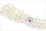
 Ramkot Location in Nepal | |
| Coordinates: 27°43′N 85°15′E | |
| Country | |
| Province | Province No. 3 |
| District | Kathmandu |
| Population (1991) | |
| • Total | 5,327 |
| Time zone | UTC+5:45 (Nepal Time) |
Location and Area
Ramkot is a place situated at Nagarjun municipality.Druk Amitabh mountain with biggest Buddha stupa all over Nepal is one of its center of attraction. Switzerland park in Dahachowk is famous for emerging picnic spot. Kalu Pandey Grave, Bindhyabasini temple and Manakamana temple are amazing place to observe. It is a historical hill station related with King Prithvi Narayan Shah. It is suitable place to observe 3 major cities of Kathamndu Valley. It is election centre 9 of Kathmandu.
Dandapauwa
Dandapauwa डाँडापौवा (27°43′N 85°16′E) is a ward of Ramkot, Nepal. It borders Taufical, Fasku, Puldol, JayantiGaun and Gotamthok. The Manamati and Kolpini rivers flow through Dandapauwa.
School and colleges
Shishu Nikunja School, Mahamanju Shree School, Gajurmukhee Secondary Boarding School,Daisy Educational Academy, Nabin Jyoti school, Ratna RAjya Madhyamic Bidhyala and Shree Sitaram Higher Secondary School are the only schools in this area.
Sitaram and Ratna Rajya is a government high school. Another government owned primary school is Jyothi Primary school is on toufical.
Demographics
Dandapauwa is inhabited by Newar, Sanyasi Brahmin Chhetrie tamang Muslims make up the rest.it is really amazing place.
Economy
most of the people are engaged in agriculture where local tunnel are built for farm. One grain factory, one chow-mien factory, one bitumen factory, and medical pharma operate there. The tobacco factory was closed in 2013 due to extreme pollution emission.
Small-scale industry and companies are there. The finances are Kotasya Bhairab and Shyameshwor, named after local temples. Rupesh Computers, Inc., is there[2][3] later known as Rupesh Inc.[4]
Temples
Mahankal, Shyameshwor, mahadev mandir of Gothamthok, Kaudu Bhagwati, Panchakanya mandir in purigaun, Kallabari,Chundevi,Bhimsen mandir Indradaha, Manakamana at top of Dahachowk and Radha - Krishna Mandir are famous temples there. Shyameshwor is notable for Shivaratri and Radha Krishna Mandir is famous for Shree Krishna Janma Asthami.
Jothishwor Mahadev mandir is located on the heart of Toufical.
Infrastructures
It has many high school i.e. Sitaram Higher Secondary School, Sishu nikunja higher secondary school The Schools in this area are Gajurmukhee Secondary Boarding School and Ratna Rajya School. Wonders academy is only pre-primary school and Jyoti Academy is only lower secondary school of this area. It has one playground . Part of Padma Colony, sitapaila lies on it. Brihat housing is one popular colony in Fasku. Temples in this area are Mahankal,Radha-Krishna Mandir and Shyameshwor Mandir. Dandapauwa has one Bitumen factory, one chow mein factory and one grain factory. It also has one Party palace i.e. Ramkot Party Palace.
Politics
Recently held national election of 2070 BS i.e. 2013 Nepalese Constituent Assembly election has favoured Nepali Congress as victor. Dhyan Govinda Ranjit of Nepali Congress was elected as a Member of Nepalese Constituent Assembly/Member of Parliament from this area. National election held in 2074 B.S was in favour of UML where Krishna Gopal Shrestha was elected at parliament member.
References
- "Nepal Census 2001". Nepal's Village Development Committees. Digital Himalaya. Retrieved 2014-01-13.
- "Innovation Cup". Rupesh-inc.tk. Retrieved 2014-02-21.
- "Rupesh Inc". Rupeshinc.wix.com. Retrieved 2014-01-17.
- Poudel, Rupesh (2013-12-27). "Rupesh Inc". Rupesh-inc.blogspot.com. Retrieved 2014-02-21.