Daanchhi
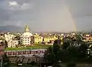
Danchhi is a village and former Village Development Committee that is now part of Kageshwari-Manohara Municipality in Kathmandu District in Province No. 3 of central Nepal. At the time of the 2011 Nepal census, it had a population of 11246 and had 2,593 households in it.[1] Danchhi is now included in Kageswori Manohara Municipality. Danchhi/Thali is bounded by Bagmati and Manohara river. The major places include Thali/थली, Nayapati, Bhadrawas, Hariyalinagar, Dumakhal, and Gajarkot. The major government schools are Shree Sahid Aadarsha Uchha MaVi, Shree Kanti Bhairab MaVi, and Shree Chaulanarayan PraVi. Private schools include Miniland English High School, Mount Everest Secondary School, Pragya Sadan School, Alpine Academy, and Hindu Vidhya Peeth.
Danchhi
डाँछी | |
|---|---|
Village of Kageshwari-Manohara Municipality | |
| Nickname(s): Thali, Danchhi | |
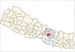
 Danchhi Location in Nepal | |
| Coordinates: 27.73°N 85.41°E | |
| Country | |
| Province | No. 3 |
| District | Kathmandu |
| Government Local Government | |
| • Type | Municipality |
| • Member of Parliament | Madhav Kumar Nepal |
| • Mayor | Krishna Hari Thapa |
| Population (2011) | |
| • Total | 11,246 |
| Time zone | UTC+5:45 (Nepal Time) |
| Postal code | 44600 |
| Area code(s) | 01 |
| Website | http://www.kageshworimanoharamun.gov.np/en |
In recent local election Krishna Hari Thapa was elected as the Mayor of the Municipality. He garnered 8,969 votes. He edged Nepali Congress’ Upendra Karki by 482 vote margin. Likwise, UML Bindu Simkhada was elected to the pose to deputy mayor of the same municipality. She received 9,182 votes. Meanwhile, UML clinched victory in ward number 1, 3, 5, 6, 8 and 9 while Nepali Congress won in ward numbers 2, 4 and 7 in the municipality.
Kathmandu valley outer ringroad will pass through this place.
Industries and Economy
- Korean Company
- Gokarna Forest Resort
- Kumari Bank
- NIC Asia Bank
- Kanti Bhairab Hume Pipe Pvt Ltd
Hindu temples
- Ganesh Temple, Nayagaun
- Kolmateswor Temple, Simkhadagaun
- RadhaKrishna Temple, Thali
- Vimadevi Temple, Thali
- Dumadevi Temple, Dumakhal
- KANTI BHAIRAB TEMPLE, DANCHHI
Tourist attractions
- Bhimbadi Danda
- Gokarna Forest Golf Resort http://gokarna.com/
- Sahid Bann Batika
- Firfire Danda
- Simkhadagaun Pani Tanki
- Danchhi Pani Tanki
References
- "National Population and Housing Census 2011" (PDF). Government of Nepal, National Planning Commission Secretariat, Central Bureau of Statistics. Archived from the original (PDF) on 2013-01-24. Retrieved November 1, 2012.
External links
- UML wins mayor and deputy of Kageswari Manohara Municipality
- Govt gives final push for outer ring road project