Ranch to Market Road 1832
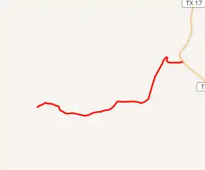
Ranch to Market Road 1832 (RM 1832) is a 10.9-mile (17.5 km) route maintained by the Texas Department of Transportation (TxDOT) that connects the Boy Scouts of America's Buffalo Trails Scout Ranch to State Highway 17 about 25.1 miles (40.4 km) north of Fort Davis.[2] The road is part of the state's Farm and Ranch to Market Road System.
| ||||
|---|---|---|---|---|
| ||||
| Route information | ||||
| Maintained by TxDOT | ||||
| Length | 10.859 mi[1] (17.476 km) | |||
| Existed | 1953–present | |||
| History | Formerly a route in Callahan County | |||
| Major junctions | ||||
| West end | Buffalo Trails Scout Ranch | |||
| East end | ||||
| Location | ||||
| Counties | Jeff Davis | |||
| Highway system | ||||
| ||||

RM 1832 is located entirely within Jeff Davis County. The route number, however, was previously assigned to a road in Callahan County from 1951 to 1953.[1]
The rural road does not pass through any cities or towns but instead winds through ranch land along its length with no highway intersections beyond its terminus at SH 17.
History
Callahan County

On November 20, 1951, Farm to Market Road 1832 (FM 1832) was originally designated as a 6.0-mile (9.7 km) road linking the former U.S. Route 80 (now Interstate 20) 1.0 mile (1.6 km) east of Putnam to a road intersection in eastern Callahan County. On December 17, 1952, FM 1832 was extended to US 380 near Moran. That designation was dropped on January 28, 1953 when the road was assigned as an extension of FM 880.[1]
Jeff Davis County
On March 26, 1953, FM 1832 was re-designated as the present route in Jeff Davis County. This was to be cancelled and given to Jeff Davis County when construction is completed.[3] When this route was constructed by September 20, 1954, FM 1832 was cancelled. On September 20, 1955, the state again assumed control over the road and its designation was restored. On October 27, 1959, the road was given its current ranch to market designation.[1]
Route description
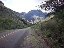
Ranch to Market Road 1832 is an isolated road with no major intersections west of its terminus at SH 17 and passes through no cities or towns. The road has narrow lanes and unpaved, grassy shoulders. The route often curves tightly over the contours of the terrain and relies on low-water crossings subject to flooding at streams. The speed limit on RM 1832 is 70 miles per hour (113 km/h) daytime and 65 miles per hour (105 km/h) at night.
The route passes through ranch land along its length. Cattle guards cross the road between pastures, and much of the road is not fenced. Loose livestock pose a hazard to motorists. The land adjoining the road's right of way including unfenced portions is private property.
Major intersections
The entire route is in Jeff Davis County.
| Location | mi[1] | km | Destinations | Notes | |
|---|---|---|---|---|---|
| | 0.000 | 0.000 | Western terminus at Buffalo Trail Scout Ranch | ||
| 10.859 | 17.476 | Eastern terminus | |||
| 1.000 mi = 1.609 km; 1.000 km = 0.621 mi | |||||
References
- Transportation Planning and Programming Division (n.d.). "Ranch to Market Road No. 1832". Highway Designation Files. Texas Department of Transportation. Retrieved 2009-12-07.
- Google (2009-12-06). "SH 17 between Fort Davis and RM 1832" (Map). Google Maps. Google. Retrieved 2009-12-06.
- (PDF) https://publicdocs.txdot.gov/minord/MinuteOrderDocLib/003676444.pdf. Missing or empty
|title=(help)
External links
![]() Geographic data related to Ranch to Market Road 1832 at OpenStreetMap
Geographic data related to Ranch to Market Road 1832 at OpenStreetMap