Ranganadi River
The Ranganadi River (also known as Paniyor River) is a sub-tributary of the Brahmaputra River in the Indian state of Assam. The river originates from Nilam, Marta and Tapo mountain ranges of Himalayan foothills of Arunachal Pradesh. The Ranganadi river then enters Assam at Johing of Lakhimpur district and flows 60 km through Lakhimpur district before its confluence with the Subansiri River at Pokoniaghat of Lakhimpur district.
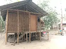
House (Chang Ghar) of Mising people on the bank of Ranganadi River in Lakhimpur district
| Ranganadi River Paniyor River | |
|---|---|
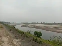 Ranganadi River in Lakhimpur district | |
  | |
| Native name | ৰঙানদী (Assamese) |
| Location | |
| State | Arunachal Pradesh & Assam |
| District | Lakhimpur District |
| Physical characteristics | |
| Source | Nilam, Marta and Tapo mountain ranges of Himalayan foothills |
| • location | Arunachal Pradesh |
| • coordinates | 27°25′48.7″N 93°43′31.3″E |
| Mouth | Subansiri River |
• location | Pokoniaghat, Lakhimpur district, Assam |
• coordinates | 27°01′27.72″N 94°03′05″E |
| Basin features | |
| Progression | Ranganadi River - Subansiri River- Brahmaputra River |
Ranganadi Dam
The Ranganadi Dam is a concrete-gravity diversion dam on the Ranganadi River located at Lower Subansiri district of Arunachal Pradesh. [1]
References
- "Reservoir of dams". India Environmental Portal. May 2008. Archived from the original on 24 January 2010. Retrieved 28 August 2010.
This article is issued from Wikipedia. The text is licensed under Creative Commons - Attribution - Sharealike. Additional terms may apply for the media files.