Red Sea (state)
Red Sea (Arabic: البحر الأحمر Wilayat Al Baḥr al Aḥmar) is one of the 18 wilayat or states of Sudan.[3] It has an area of 212,800 km²[4] and an estimated population of 1,482,053 (2018). Port Sudan is the capital of the state.[4] Sudan claims, but does not control, the Halayib Triangle, a region disputed between Sudan and Egypt. The original inhabitants of the State are the Beja people, who constitute above 65% of the current population with lower wealth and power in the region.
Red Sea
البحر الأحمر Wilayat al-Bahr al-Ahmar | |
|---|---|
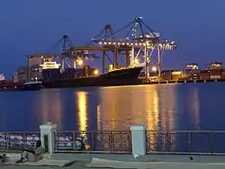 Port Sudan | |
 Seal | |
_(Kafia_Kingi_disputed).svg.png.webp) Location in Sudan. | |
| Coordinates: 19°35′N 35°37′E | |
| Country | |
| Region | Eastern Sudan States Coordinating Council |
| Capital | Port Sudan |
| Government | |
| • Governor | Vacant |
| Area | |
| • Total | 218,887 km2 (84,513 sq mi) |
| Population (2018 (est.)) | |
| • Total | 1,482,053[1] |
| • Density | 6.6/km2 (17/sq mi) |
| Time zone | UTC+2 (CAT) |
| HDI (2017) | 0.518[2] low |
Geography
Overview
Geographically, in the east, bordering the state, is the Red Sea. Inland, mountains run from north to south, which are interrupted by arid plains. To the northwest is the Nubian Desert. The Siyal Islands are located in the disputed area between Egypt and Sudan in the northeast.
The Sudanese state is divided into the eight administrative areas: Bur Sudan (Port Sudan), Gebiet Elma'din, Halayib, Haya, Sawakin, Sinkat, Gunob Awlieb, Derodieb, Tokar and Ageeg.
Localities
- Port Sudan (Capital)
- Gebiet Elmadin
- Halayib
- Haya
- Sawakin
- Sinkat
- Gunob Awlieb
- Derodieb
- Tokar
- Ageeg
References
- Sub-national Population Projections of Sudan and Age-Sex Composition. gov.sd
- "Sub-national HDI - Area Database - Global Data Lab". hdi.globaldatalab.org. Retrieved 2018-09-13.
- States of Sudan. statoids.com
- "Red Sea State" on the Republic of Sudan website
|