Sennar (state)
Sennar (Arabic: سنار Sannār) is one of the 18 wilayat or states of Sudan. It has an area of 37,844 km² and a population of approximately 1,100,000 (2000).
Sennar
سنار Sinnar | |
|---|---|
 Seal | |
.svg.png.webp) Location in Sudan. | |
| Coordinates: 12°58′N 34°3′E | |
| Country | |
| Region | Sennar Province |
| Governor | 2015 |
| Capital | Singa |
| Government | |
| • Type | State Government |
| • Governor | Aldaw Almahi |
| Area | |
| • Total | 37,844 km2 (14,612 sq mi) |
| Population (2006 (est.)) | |
| • Total | 1,532,085 |
| Time zone | UTC+2 (CAT) |
| HDI (2017) | 0.493[1] low |
Location
Sinar State is delimited by Al-Gazira State in the north, The Blue Nile State in the south, Al-Gedaref State and the Sudanese Ethiopian borders in the east, and the White Nile State & the Upper Nile State of South Sudan in the west. Singa is the capital of Sennar State; another significant town is Sennar (or Mukwar), the largest city in the state. Other commercial towns include El-Suki and El-Dinder.
Population and livelihood
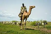
The main economic activity is agriculture, with the irrigated scheme of Suki, the sugar factory of Sennar, and a number of fruit growers (including bananas and mangoes) located on the banks of the Blue Nile. In terms of education The University Of Sennar is the only higher education university throughout all the state, attended by all its residents.
Tourism
The state is famous for its Dinder National Park.
See also
|
References
- "Sub-national HDI - Area Database - Global Data Lab". hdi.globaldatalab.org. Retrieved 2018-09-13.
- UNDP, NSDDRC-SC (27–29 April 2010). "Socio-economic and opportunity mapping Assessment report for Sinnar State Joint mission (NSDDRC-SC/ UNDP)" (PDF). Socio-economic and opportunity mapping Assessment report for Sinnar State Joint mission (NSDDRC-SC/ UNDP).