South Kordofan
South Kordofan (Arabic: جنوب كردفان Ǧanūb Kurdufān) is one of the 18 wilayat or provinces of Sudan. It has an area of 158,355 km²[2] and an estimated population of approximately 1,100,000 people (2000).[3] Kaduqli is the capital of the state. It is centered on the Nuba Hills. At one time it was supposed that South Kordofan was the only state in (North) Sudan suitable for producing oil, but oil has also been discovered in neighboring White Nile State in larger quantities.[4]
South Kordofan
جنوب كردفان Ǧanūb Kurdufān | |
|---|---|
 Seal | |
.svg.png.webp) | |
| Coordinates: 11°8′N 29°53′E | |
| Country | |
| Region | Nuba Mountains |
| Capital | Kaduqli |
| Government | |
| • Governor | Adam Al-Faki Mohamed al-Tayeb |
| Area | |
| • Total | 79,470 km2 (30,680 sq mi) |
| Population (2006 (est.)) | |
| • Total | 1,111,859 |
| Time zone | UTC+2 (CAT) |
| HDI (2017) | 0.431[1] low |
Under the Comprehensive Peace Agreement, residents of South Kordofan were to hold popular consultations in 2011 to determine the constitutional future of the state. However, South Kordofan governor Ahmed Haroun suspended the process and violence followed.[5] Haroun had previously been charged with war crimes against civilians and crime against humanity by the International Criminal Court. However, many African Countries have exited the ICC as a consequence of perceived unfair attention towards Africa by the ICC, as nine of the court’s ten full-fledged investigations involve African politicians and warlords.
History
Although South Kordofan is part of Sudan, it is home to many pro-South Sudan communities, especially in the Nuba Mountains, some of whom fought alongside southern rebels during the long civil war.[6]
In 2009 and 2010, a series of conflicts between rival nomadic tribes in South Kordofan caused a large number of casualties and displaced thousands.
On June 6, 2011 armed conflict broke out between the forces of Northern and Southern Sudan, ahead of the scheduled independence of the South on July 9. This followed an agreement for both sides to withdraw from Abyei.[7][8] On June 20, the parties agreed to demilitarize the contested area of Abyei where Ethiopian peacekeepers were deployed.[9] Abyei is currently controlled by the United Nations Interim Security Force for Abyei.[10]
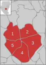
Districts of Southern Kordofan
Cities and towns of Southern Kordofan
- Kaduqli (capital)
See also
- Kordofan - overall region
- Eyes and Ears Of God – Video surveillance of Sudan - documentary film
- Nuba Mountains
- Languages of the Nuba Mountains
- Ghulfan people
References
- "Sub-national HDI - Area Database - Global Data Lab". hdi.globaldatalab.org. Retrieved 2018-09-13.
- Sources disagree on the size of the state. The government of Sudan lists the area as 970,470 km², Statoids as 158,355 and the International Crisis Group as ""about 120,000 sq. km"" (PDF). Archived from the original (PDF) on 2008-12-11. (1.19 MB) (p. 1)
- South Kordofan State Archived 2011-05-26 at the Wayback Machine, Sudan Ministry of the Cabinet Affairs, 22 July 2008
- Interview with Abdel Aziz Adam Al Hilu (commander of SPLA in Nuba mountains), 18 June 2011, by Tomo Križnar
- Martell, Peter (2011-06-20). "BBC News - Is Sudan heading for an acrimonious divorce?". Bbc.co.uk. Retrieved 2014-02-10.
- "BBC News - Sudan's South Kordofan: 'Huge suffering from bombs'". Bbc.co.uk. 2011-06-14. Retrieved 2014-02-10.
- Archived June 29, 2011, at the Wayback Machine
- "BBC News - Sudan: Barack Obama calls for ceasefire". Bbc.co.uk. 2011-06-15. Retrieved 2014-02-10.
- Archived June 29, 2011, at the Wayback Machine
- https://foreignpolicy.com/2018/06/06/conflict-in-abyei-could-reignite-south-sudans-civil-war/
| Wikimedia Commons has media related to South Kurdufan state. |
External links
|