Reefton
Reefton is a small town in the West Coast region of New Zealand, some 80 km northeast of Greymouth, in the Inangahua River valley. State Highway 7 passes through the southern part of the town, and State Highway 69 runs north to connect to State Highway 6. Ahaura is 44 km south-west of Reefton, Inangahua Junction is 34 km to the north, Maruia is 63 km to the east, and the Lewis Pass is 66 km to the south-east.[2][3]
Reefton | |
|---|---|
 Broadway | |

| |
| Coordinates: 42°6′55″S 171°51′47″E | |
| Country | New Zealand |
| Region | West Coast |
| District | Buller District |
| Ward | Inangahua |
| Electorates | West Coast-Tasman Te Tai Tonga |
| Population (2018)[1] | |
| • Total | 927 |
In 1888 Reefton became the first town in New Zealand and the Southern Hemisphere to receive electricity,[4] the work of Walter Prince,[5] and its streets were lit by commercial electricity generated by the Reefton Power Station. The Reefton Power House Charitable Trust Inc has raised $4.5 million for a restructure project and work started on buildings and a 1.8 kilometres (1.1 mi) water race in 2019.[6]
Reefton is home to the Inangahua County Library.[7]
Name
The rich veins of gold found in a quartz reef near the town led to its name, originally spelled "Reef Town". Two nicknames in use soon after it was founded were "Rest Town" and "Quartzopolis".[8] The main street, Broadway, was named after West Coast magistrate Charles Broad. The nearby Wealth of Nations mine was named after Adam Smith's book because the gold been discovered by another Adam Smith (no relation).[8]

(U.S. English, Stamp mill)
Demographics
| Year | Pop. | ±% p.a. |
|---|---|---|
| 1996[9] | 1,044 | — |
| 2001[9] | 987 | −1.12% |
| 2006[1] | 981 | −0.12% |
| 2013[1] | 1,056 | +1.06% |
| 2018[1] | 927 | −2.57% |
| Population counts from the New Zealand census. Populations before 2006 may use slightly different boundaries. | ||
Reefton had a population of 927 at the 2018 New Zealand census, a decrease of 129 people (-12.2%) since the 2013 census, and a decrease of 54 people (-5.5%) since the 2006 census. There were 447 households. There were 471 males and 456 females, giving a sex ratio of 1.03 males per female. The median age was 51.9 years (compared with 37.4 years nationally), with 132 people (14.2%) aged under 15 years, 120 (12.9%) aged 15 to 29, 453 (48.9%) aged 30 to 64, and 222 (23.9%) aged 65 or older.
Ethnicities were 90.0% European/Pākehā, 13.3% Māori, 1.0% Pacific peoples, 2.9% Asian, and 2.6% other ethnicities (totals add to more than 100% since people could identify with multiple ethnicities).
The proportion of people born overseas was 11.3%, compared with 27.1% nationally.
Although some people objected to giving their religion, 53.1% had no religion, 32.0% were Christian, 0.3% were Muslim and 1.9% had other religions.
Of those at least 15 years old, 63 (7.9%) people had a bachelor or higher degree, and 246 (30.9%) people had no formal qualifications. The median income was $22,900, compared with $31,800 nationally. The employment status of those at least 15 was that 306 (38.5%) people were employed full-time, 117 (14.7%) were part-time, and 24 (3.0%) were unemployed.[1]
Mining
Gold was first discovered near the town in 1866, although the major discovery was made in 1870. An earlier settlement, known as Ross Town, had been established on the opposite bank of the Inangahua River around 1870, but most businesses shifted across the river in 1871 to be nearer the quartz mining.[8] Soon after, the town briefly boasted a population of several thousand. This later dwindled to less than a thousand. Other industries in the town are coal mining, forestry, tourism and angling. A new gold mine is planned to open in 2024, it is expected to employ 100 people.[10]
Broadcast and print media
Locally received radio stations include repeaters of both The Hits from Greymouth and Coast FM from Westport. The Greymouth Star newspaper is also received daily in the town.
Railways
Reefton is located on the Stillwater–Westport Line railway, which diverges from the Midland Line in Stillwater. On 29 February 1892, the line was opened to Reefton, but it terminated on the southern bank of the Inangahua River opposite the town. Early in the 20th century, a bridge was built across the river and the present-day station established in Reefton. The line was opened beyond Reefton to Cronadun in 1908, but it was not until 5 December 1943 that the line officially became a through route to Westport, though trains had been operating the length of the line since July 1942. On 3 August 1936, a railcar passenger service began operating in the morning between Hokitika and Reefton utilising small Leyland diesel railcars, but low patronage meant this service ceased to operate all the way to Reefton in August 1938. In the early 1940s, much larger Vulcan railcars were introduced to New Zealand and they provided two services to Reefton: one local service from Greymouth that terminated in Reefton, and a service that ran between Westport and Stillwater to connect with the West Coast Express. In 1967, all passenger services through Reefton ceased. Today, the primary traffic on the railway is coal, with multiple coal trains operating daily.
Climate
Located in the Inangahua Valley at an altitude of 194m, Reefton falls under the Köppen-Geiger climate classification of Cfb (Oceanic). At an average temperature of 15.9 °C, February is the warmest month. July is the coldest month, at 6.8 °C. Reefton's average annual temperature is 11.4 °C. On average, snowfall occurs on 1.4 days annually, and an average of 22.1 days per year will exceed 26.7°C (80°F). During an average winter, Reefton can expect to see 47 days of frost.
| Climate data for Reefton, 194 m | |||||||||||||
|---|---|---|---|---|---|---|---|---|---|---|---|---|---|
| Month | Jan | Feb | Mar | Apr | May | Jun | Jul | Aug | Sep | Oct | Nov | Dec | Year |
| Average high °C (°F) | 21.4 (70.5) |
21.6 (70.9) |
19.8 (67.6) |
16.8 (62.2) |
13.5 (56.3) |
10.8 (51.4) |
10.5 (50.9) |
12.0 (53.6) |
14.0 (57.2) |
15.7 (60.3) |
17.8 (64.0) |
19.6 (67.3) |
16.1 (61.0) |
| Daily mean °C (°F) | 16.3 (61.3) |
16.5 (61.7) |
14.8 (58.6) |
12.0 (53.6) |
9.0 (48.2) |
6.6 (43.9) |
6.0 (42.8) |
7.4 (45.3) |
9.4 (48.9) |
11.1 (52.0) |
13.0 (55.4) |
14.9 (58.8) |
11.4 (52.5) |
| Average low °C (°F) | 11.2 (52.2) |
11.4 (52.5) |
9.8 (49.6) |
7.3 (45.1) |
4.7 (40.5) |
2.5 (36.5) |
1.6 (34.9) |
2.8 (37.0) |
4.8 (40.6) |
6.6 (43.9) |
8.3 (46.9) |
10.2 (50.4) |
6.7 (44.1) |
| Average rainfall mm (inches) | 98.8 (3.89) |
70.3 (2.77) |
81.2 (3.20) |
105.3 (4.15) |
118.7 (4.67) |
115.3 (4.54) |
115.9 (4.56) |
110.0 (4.33) |
122.6 (4.83) |
127.7 (5.03) |
116.5 (4.59) |
116.2 (4.57) |
1,298.4 (51.12) |
| Source 1: Climate-data.org[11] | |||||||||||||
| Source 2: weatherbase.com[12] | |||||||||||||
History timeline
- 1866 – Gold discovered
- 1888 – Town electricity supply commenced
- 1892 – Railway line opened
- 1908 – Rail line to Cronadun opened
- 1912 – Mine workers locked out[13]
- 1967 – Rail passenger services ceased
Education
The first state school in Reefton was founded in 1878, and there were once 24 schools in the area.[14]
Reefton Area School is a composite (years 1–13) school with a roll of 150 as of March 2020.[15][16] It was formed by the merger of Reefton School and Inangahua College (earlier called Reefton District High School)[14] in 2004.[17]
Sacred Heart School is a full primary (years 1–8) school with a roll of 39.[18] It is a state integrated Catholic school.[19] Both schools are coeducational.
Notable people
- Marty Banks – rugby union player, born and grew up in Reefton
- Amy Castle – museum curator and entomologist, born in Reefton
- Elisabeth Croll – anthropologist, born in Reefton
- Phill Jones – basketball player, grew up in Reefton
- Edward Smyrk – cricketer, born in Reefton
Gallery
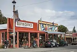
 Broadway
 Reefton Court House
 Reefton Oddfellows Hall
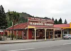 Broadway Tearooms & Bakery
 Reefton Roman Catholic Church
 Old Knox Church
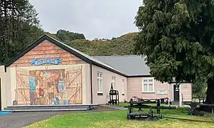 Blacks Point Museum
 Reefton Masonic building
- Reefton Oddfellows Hall

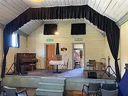
 Roll of members
References
- "Statistical area 1 dataset for 2018 Census". Statistics New Zealand. March 2020. Reefton (309800). 2018 Census place summary: Reefton
- Peter Dowling, ed. (2004). Reed New Zealand Atlas. Reed Books. map 64. ISBN 0-7900-0952-8.
- Roger Smith, GeographX (2005). The Geographic Atlas of New Zealand. Robbie Burton. map 149. ISBN 1-877333-20-4.
- McKinnon, Malcolm, ed. (1997). New Zealand Historical Atlas. David Bateman. Plate 88.
- "Reefton Power Station". Engineering Heritage New Zealand. Retrieved 29 June 2016.
- "Power to the People". RNZ. 15 November 2019. Retrieved 12 September 2020.
- "Buller District Council, New Zealand » Library locations & opening hours". Retrieved 23 September 2020.
- Reed, A. W. (1979). The Reed dictionary of New Zealand place names (2002 ed.). Auckland [N.Z.]: Reed. p. 433. ISBN 0-7900-0761-4. OCLC 49290681.
- http://www2.stats.govt.nz/domino/external/web/commprofiles.nsf/htmldocs/Reefton+Urban+Area+Community+Profile
- "New Reefton gold mine promises to provide 'many opportunities' for locals". Stuff. 7 August 2020. Retrieved 10 August 2020.
- | "Climate-data.org – Climate Data for Cities Worldwide". openstreetmap.org. Retrieved 17 December 2019.
- /ref> "Weatherbase". CantyMedia. Retrieved 28 November 2020.
- "The Reefton lockout," Maoriland Worker, 14 June 1912. Archived at paperspast.natlib.govt.nz. Retrieved 29 March 2018.
- "District School Reunion" (PDF). 2003. Archived from the original (PDF) on 26 May 2010.
- "New Zealand Schools Directory". New Zealand Ministry of Education. Retrieved 26 April 2020.
- Education Counts: Reefton Area School
- "School Mergers, Closures and New Schools" (XLS). Education Counts. 2004.
- Education Counts: Sacred Heart School
- "Education Review Report: Sacred Heart School". Education Review Office. December 2007.
External links
| Wikimedia Commons has media related to Reefton, New Zealand. |
| Wikivoyage has a travel guide for Reefton. |
- Reefton i-SITE Visitor Centre
- Department of Conservation – Reefton short walks
- Reefton Area School