Hokitika
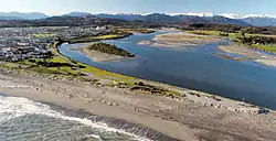
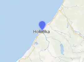
Hokitika is a town in the West Coast region of New Zealand's South Island, 40 kilometres (25 mi) south of Greymouth, and close to the mouth of the Hokitika River. It is the seat and largest town in the Westland District. The town's estimated population is 2,920 as of June 2020.[1]
Hokitika | |
|---|---|
 Hokitika township | |
| |
| Coordinates: 42°42′56″S 170°58′5″E | |
| Country | New Zealand |
| Region | West Coast |
| District | Westland District |
| Ward | Hokitika |
| Settled by Europeans | 1864 |
| Electorates | West Coast-Tasman Te Tai Tonga |
| Population (June 2020)[1] | |
| • Total | 2,920 |
| Time zone | UTC+12 (NZST) |
| • Summer (DST) | UTC+13 (NZDT) |
| Postcode(s) | 7810 |
| Area code(s) | 03 |
| Local iwi | Ngāi Tahu |
On a clear day Aoraki / Mount Cook can clearly be seen from Hokitika's main street.
History
The land where Hokitika stands was purchased in 1860 from Māori when Poutini Ngāi Tahu chiefs signed the Arahura Deed. This was the sale of the whole of the West Coast region, apart from small areas reserved for Māori. It was almost 3 million hectares and sold to the Crown for £300.[2][3][4]
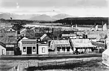
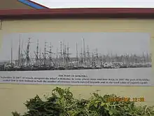
Founded on gold mining in 1864, it was a centre of the West Coast Gold Rush and grew very quickly.[2] By late 1866, it was one of New Zealand's most populous centres. On 16 September 1867, there were 41 vessels alongside the wharf at Hokitika, in some places three and four deep. In 1867, the port of Hokitika ranked first in New Zealand in both the number of vessels entered inwards and in the total value of exports; principally gold.
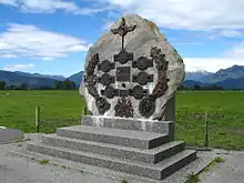
On 8 March 1868 a mock funeral was held in protest about the conviction and hanging of three Irish Fenians in Manchester – the Manchester Martyrs. The funeral was led by Roman Catholic Father William Larkin and a Celtic Cross was erected in the cemetery. Larkin was later arrested, charged, and convicted of riot and seditious libel.[5]
In 1873 Hokitika became the capital of the short-lived Westland Province which lasted from 1873 until the abolition of provinces in 1876.
In October 1941, three Hokitika police officers (and a policeman stationed in the neighbouring locality of Kaniere), along with a field instructor for the Canterbury education board, were killed when a local farmer, Stanley Graham, went on a shooting rampage and killed seven people, including two armed Home guard personnel.
In the ensuing manhunt, the biggest in New Zealand history, overseen by the Commissioner of Police, Denis Cummings, more than 100 New Zealand Police and several hundred New Zealand Army & Home Guard searched the area for the gunman for 12 days, with orders to shoot him on sight if found still armed. On 20 October, after being spotted by two police constables and a local civilian carrying his rifle and ammunition belts, Graham was fatally wounded by a police constable and died the next day.[6]
The population has declined greatly since that time but the population of the Westland District is now on the rise thanks to "lifestyle inhabitants". Almost 30% of the district's rate-payers live outside of Hokitika.
Geography
Climate
Hokitika has an oceanic climate, with mild summers, cool winters, and rainfall evenly distributed across the year. It is one of the wettest places in New Zealand, with over 2,800 mm (110 in) of rainfall per year.
| Climate data for Hokitika Airport (1936–2015, Humidity 1961–2015, Sunshine 1964–2015) | |||||||||||||
|---|---|---|---|---|---|---|---|---|---|---|---|---|---|
| Month | Jan | Feb | Mar | Apr | May | Jun | Jul | Aug | Sep | Oct | Nov | Dec | Year |
| Record high °C (°F) | 29.7 (85.5) |
28.4 (83.1) |
26.7 (80.1) |
24.5 (76.1) |
26.7 (80.1) |
18.6 (65.5) |
18.8 (65.8) |
19.8 (67.6) |
22.8 (73.0) |
24.0 (75.2) |
27.4 (81.3) |
27.1 (80.8) |
29.7 (85.5) |
| Average high °C (°F) | 19.4 (66.9) |
19.8 (67.6) |
18.8 (65.8) |
16.6 (61.9) |
14.3 (57.7) |
12.3 (54.1) |
11.9 (53.4) |
12.6 (54.7) |
13.8 (56.8) |
14.9 (58.8) |
16.4 (61.5) |
18.2 (64.8) |
15.7 (60.3) |
| Daily mean °C (°F) | 15.5 (59.9) |
15.9 (60.6) |
14.7 (58.5) |
12.6 (54.7) |
10.1 (50.2) |
8.1 (46.6) |
7.4 (45.3) |
8.3 (46.9) |
9.8 (49.6) |
11.1 (52.0) |
12.6 (54.7) |
14.4 (57.9) |
11.7 (53.1) |
| Average low °C (°F) | 11.7 (53.1) |
11.9 (53.4) |
10.7 (51.3) |
8.5 (47.3) |
6.0 (42.8) |
3.8 (38.8) |
2.9 (37.2) |
4.0 (39.2) |
5.8 (42.4) |
7.3 (45.1) |
8.7 (47.7) |
10.7 (51.3) |
7.7 (45.9) |
| Record low °C (°F) | 4.7 (40.5) |
3.5 (38.3) |
−0.4 (31.3) |
−0.7 (30.7) |
−2.2 (28.0) |
−3.2 (26.2) |
−4 (25) |
−2.9 (26.8) |
−2.1 (28.2) |
−1.3 (29.7) |
−0.6 (30.9) |
2.9 (37.2) |
−4 (25) |
| Average rainfall mm (inches) | 242.3 (9.54) |
178.9 (7.04) |
215.0 (8.46) |
235.8 (9.28) |
242.1 (9.53) |
249.3 (9.81) |
219.3 (8.63) |
231.9 (9.13) |
256.5 (10.10) |
276.3 (10.88) |
239.6 (9.43) |
268.5 (10.57) |
2,849.7 (112.19) |
| Average rainy days (≥ 1.0 mm) | 12.4 | 10.4 | 12.6 | 13.3 | 14.7 | 13.8 | 13.5 | 14.8 | 16.8 | 17.3 | 15.0 | 15.8 | 170.5 |
| Average relative humidity (%) (at 9am) | 83.1 | 85.9 | 85.5 | 86.0 | 87.5 | 87.1 | 85.5 | 84.2 | 82.3 | 81.9 | 80.6 | 81.9 | 84.3 |
| Mean monthly sunshine hours | 209.5 | 186.8 | 171.9 | 139.9 | 119.2 | 104.0 | 124.3 | 138.9 | 142.8 | 164.1 | 181.1 | 194.6 | 1,877 |
| Source: CliFlo[7] | |||||||||||||
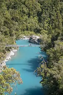
Hokitika Gorge
Nearby Hokitika Gorge is a popular short tourist walk, with vibrant blue water and a "swing" (metal rope suspension) bridge.[8][9]
Demographics
The Hokitika urban area, as defined by Statistics New Zealand, covers 3.91 km2 (1.51 sq mi) and is coterminous with the Hokitika statistical area. The urban area has an estimated population of 2,920 as of June 2020.[1]
| Year | Pop. | ±% p.a. |
|---|---|---|
| 2006 | 3,078 | — |
| 2013 | 2,967 | −0.52% |
| 2018 | 2,892 | −0.51% |
| Source: [10] | ||
Hokitika had a population of 2,892 at the 2018 New Zealand census, a decrease of 75 people (-2.5%) since the 2013 census, and a decrease of 186 people (-6.0%) since the 2006 census. There were 1,305 households. There were 1,374 males and 1,521 females, giving a sex ratio of 0.9 males per female. The median age was 47.5 years (compared with 37.4 years nationally), with 459 people (15.9%) aged under 15 years, 474 (16.4%) aged 15 to 29, 1,278 (44.2%) aged 30 to 64, and 687 (23.8%) aged 65 or older.
Ethnicities were 86.4% European/Pākehā, 20.1% Māori, 1.7% Pacific peoples, 4.9% Asian, and 1.3% other ethnicities (totals add to more than 100% since people could identify with multiple ethnicities).
The proportion of people born overseas was 11.6%, compared with 27.1% nationally.
Although some people objected to giving their religion, 47.7% had no religion, 41.3% were Christian, 0.8% were Hindu, 0.4% were Muslim, 0.3% were Buddhist and 1.8% had other religions.
Of those at least 15 years old, 330 (13.6%) people had a bachelor or higher degree, and 654 (26.9%) people had no formal qualifications. The median income was $27,300, compared with $31,800 nationally. The employment status of those at least 15 was that 1,146 (47.1%) people were employed full-time, 408 (16.8%) were part-time, and 57 (2.3%) were unemployed.[10]
Economy and culture
The major industries of greenstone (pounamu), gold, coal, and forestry have all dwindled over the last century, but a growing ecotourism industry has grown up and the town is starting to show signs of recovery. It has become a major tourist stop on the West Coast's main highway route, with carving of greenstone an important local industry. It is also gaining a reputation for its annual wild food festival which has been running since 1990.[11]
Seaview Asylum was once the town's biggest employer.[12]
Another important industry is dairying, with Westland Milk Products being based in the town. A co-operative that has been producing dairy products for many years, Westland is increasing its production at about 10% annually, and in recent years has installed plants to produce new products such as different types of proteins, anhydrous milk fat (AMF) and others. The vast majority of its production is exported.
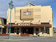
Hokitika has a 3D digital cinema,[13] the Regent Theatre,[14] due to volunteer hours[15] and grants from the Lions foundation, Lottery's commission, Development West Coast through the Major District Initiative[16] and pub charity. The Art Deco theatre is a heritage building and narrowly avoided being demolished, thanks to a last-minute coup in the management committee.[17] Community performances are also held there. Hokitika has a drama group which produce plays. It is also on the circuit for Arts on Tour and well known artists from many countries as well as New Zealand perform at the Old Lodge Theatre.
Every January, Hokitika beach hosts the Driftwood and Sand Festival. The festival involves members of the public and a sponsored artist constructing sculptures out of beach debris. Driftwood and Sand originated in beach festival run by Hokitika artist Donald Buglass in November 2002, and it has been run as an annual festival since 2003.[18]
The Hokitika Museum is housed in the town's Carnegie library building. The Hokitika Sock Machine Museum in Revell Street has on display a collection of antique sock-knitting machines. Visitors are invited to knit their own socks.[19] Hokitika also has a modern library, thriving community groups and many excellent artists.
Marae
Arahura Marae is located near Hokitika. It is a marae (tribal meeting ground) of Ngāi Tahu and its Te Rūnanga o Ngāti Waewae branch, and includes the Tūhuru wharenui (meeting house).[20][21]
In October 2020, the Government committed $161,131 from the Provincial Growth Fund to upgrade the marae, and create four jobs.[22]
Transport
State Highway 6 passes through the town.
Air New Zealand provides two flights a day to Christchurch. The Hokitika Airport is adjacent to the town, immediately to the north-east in the suburb of Seaview.
The Hokitika Branch line runs to the town from Greymouth, connecting there with the Midland Line to Christchurch.
Rail
The first rail transport was the Hokitika & Kanieri Tramway laid with wooden rails was established in 1868, with cars drawn by horses.[23] A road followed in 1873.[24]
A branch line railway known as the Hokitika Branch was established to the town from Greymouth in 1893, and an extension to Ross was open from 1909 to 1980.
Passengers to Hokitika were initially served by mixed trains that carried both goods and passengers. In 1936, these services were augmented by a Leyland diesel railbus service that ran from Hokitika to Greymouth, Christchurch, and briefly Reefton. In the early 1940s, the Vulcan railcars were introduced and they provided a twice-daily service between Ross and Christchurch via Hokitika. The mixed trains continued to operate until 1967, and all passenger services to Hokitika ceased when the Vulcan railcars stopped running past Greymouth in 1972.
Since then, the line to Hokitika has been freight only with traffic primarily coming from Westland Milk Products.
Shipping
In 1865, after the discovery of gold in the area, the town became the official port of entry of the West Coast. A boom period ensued when Hokitika was second only to Auckland, with reports of over 40 ships in the harbour at one time, with more waiting offshore.
It was a dangerous port, however, with 108 strandings and 32 ships lost from 1865 to 1867. The lack of nearby coal meant that the port declined rapidly along with the gold, though Hokitika remained an official entry port until the 1950s.[25]

ZK ADI, Air Travel's first aircraft
Airline
Hokitika's Southside airfield was the base of Air Travel, New Zealand's first airline. Air Travel carried passengers, mail and freight south from Hokitika to the glaciers and remote landing strips beyond Haast and north up to Westport. Its first scheduled flight was in December 1934. Directors were Hokitika residents: Bert Mercer, Paul Renton and Harry Newman.
After the second world war Air Travel was nationalised and became part of NAC.
Education
A school was described as "recently opened" in Hokitika in 1875, and had nearly 350 students.[26] The Hokitika District High School provided both primary and secondary education for the area for many years. Its name was changed in 1963 to Westland High School, which caters for years 7 to 13 and has a roll of 351.[27]
Hokitika School is a contributing primary (years 1–6) school with a roll of 163.[28]
St Mary's School is a full primary (years 1–8) school with a roll of 138.[29] It is a state integrated Catholic school[30] and is connected with St Mary's Catholic Church.
All these schools are coeducational. Rolls are as of March 2020.[31]
Notable people
- Agnes Addison (c.1842–1903), Scottish draper who was one of Hokitika's early businesswomen.
- Margaret Andrews Alcorn (1868–1967) and her sister Mary Alcorn (1866–1928) were interior designers and business owners
- John Urquhart Cropp (1927–2016), Olympic yachtsman
- Edward St John Daniel (1837–1868), Victoria Cross recipient, died and is buried in Hokitika
- Charlie Douglas (1840–1916), explorer and surveyor
- Alice Eyton (1874–1929), journalist, screenwriter, playwright, and novelist in Hollywood
- Stanley Graham (1900–1941), a farmer who killed seven people and was the target of New Zealand's biggest manhunt
- Bess Hudson (1875–1961), early nurse, for Dr Teichelmann
- Al Hunter (born 1950), musician, singer-songwriter
- John Lazar (1840–1916), actor, town clerk, mason
- Sharlotte Lucas (born 1991), road cyclist
- Fayne Robinson (born 1964), Māori carver
- Holly Robinson (born 1994), athlete born in Hokitika
- John Rutherford Ryley (1837–1884), who introduced antiseptic technique to New Zealand, was surgeon at Hokitika Hospital at the time
- Richard Seddon (1845–1906), New Zealand politician and Premier
Notable buildings
- Hokitika Customhouse, built 1897, a Category I historic place
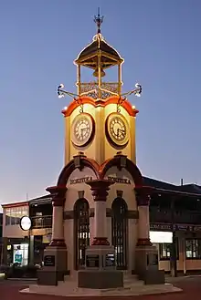
- The Hokitika Clock Tower, built 1902/3, the most prominent landmark in Hokitika
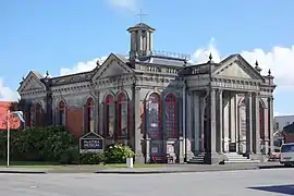
- Hokitika Museum, housed in the former Carnegie Library, built 1908
- Seaview Asylum, founded 1872 and once the town's biggest employer
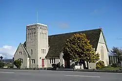
- All Saints' Church, a prominent landmark and early unfaced concrete church
- St Andrew's United Church, built in 1935, a good example of a small Gothic parish church
- Renton Hardware building (also known as the Okitiki building), completed in 1908, a Category 2 historic place
- Government Buildings (also known as Seddon House), completed in 1913, a Category 1 historic place
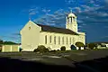
- St Mary's Catholic Church, a Category 1 historic place
 Hokitika Museum, the former Carnegie Library
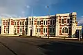 Seddon House, the former Government Buildings.
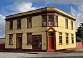 The former Bank of New South Wales building
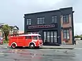 The former Fire Station building
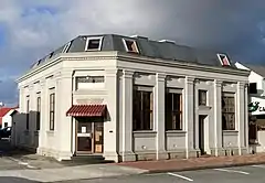

In popular culture
The events of The Luminaries, by Eleanor Catton, take place within Hokitika. The book won the Man Booker Prize in 2013.
The novel Hokitika Town, by Charlotte Randall, is set in Hokitika.
The 2004 historical novel The Colour by Rose Tremain is partially set in 1860s' Hokitika.
The 1999 movie Magik and Rose was set in Hokitika.[32]
See also
References
- "Population estimate tables - NZ.Stat". Statistics New Zealand. Retrieved 22 October 2020.
- Nathan, Simon (1 September 2016). "West Coast region – European arrival and settlement". Te Ara – the Encyclopedia of New Zealand.
- Bateman New Zealand historical atlas : ko papatuanuku e takoto nei, McKinnon, Malcolm., Bradley, Barry., Kirkpatrick, Russell., New Zealand. Department of Internal Affairs. Historical Branch., Terralink NZ Limited., Auckland, N.Z.: David Bateman in association with Historical Branch, Dept. of Internal Affairs, 1997, ISBN 1-86953-335-6, OCLC 39014539, retrieved 16 September 2020CS1 maint: others (link)
- "The Arahura Deed, 1860". Ngāi Tahu. Retrieved 23 December 2020.
- What is Truth, Newsletter – Friends of the Cathedral, Number 71, September 2007, Cathedral House, Christchurch
- H. A. Willis (1979), Manhunt : the story of Stanley Graham, Whitcoulls, ISBN 978-0-7233-0629-0
- "CliFlo – National Climate Database". NIWA. Retrieved 13 December 2015.
- https://www.backpackerguide.nz/23-unforgettable-walks-hokitika/ "Arguably the most scenic swingbridge in New Zealand!"
- "Hokitika Gorge Walk". www.doc.govt.nz. Retrieved 17 October 2020.
- "Statistical area 1 dataset for 2018 Census". Statistics New Zealand. March 2020. Hokitika (311500). 2018 Census place summary: Hokitika
- "The story so far..." Archived from the original on 3 March 2007.
- "Greymouth unit open". The Press. 1 January 2009. Retrieved 23 August 2011.
- Xpand news Archived 9 February 2013 at Archive.today
- "Hokitika's Regent Theatre - movie times & tickets". www.hokitikaregent.com. Retrieved 17 October 2020.
- "Regent Theatre in Hokitika, NZ - Cinema Treasures". cinematreasures.org. Retrieved 17 October 2020.
- "$340k funding". Archived from the original on 25 May 2010. Retrieved 12 May 2010.
- "today 3d article". Archived from the original on 3 March 2016. Retrieved 12 May 2010.
- Carroll, Joanne (24 January 2017). "Driftwood becomes art in Hokitika Beach festival". Stuff. Retrieved 31 January 2021.
- Hokitika Activity Guide.
- "Te Kāhui Māngai directory". tkm.govt.nz. Te Puni Kōkiri.
- "Māori Maps". maorimaps.com. Te Potiki National Trust.
- "Marae Announcements" (Excel). growregions.govt.nz. Provincial Growth Fund. 9 October 2020.
- Rogers, p 63
- Rogers, Anna (2005). Illustrated History of the West Coast. p. 63. ISBN 0-7900-1022-4.
- "Hokitika Customhouse". Register of Historic Places. Heritage New Zealand. Retrieved 2 May 2009.
- "Hokitika School" (3129). West Coast Times. 15 October 1875. p. 2.
- Education Counts: Westland High School
- Education Counts: Hokitika School
- Education Counts: St Mary's School
- "Education Review Report: St Mary's School Hokitika". Education Review Office. May 2008.
- "New Zealand Schools Directory". New Zealand Ministry of Education. Retrieved 26 April 2020.
- "Magik and Rose". NZ On Screen. Retrieved 18 September 2020.
External links
| Wikivoyage has a travel guide for Hokitika. |
| Wikimedia Commons has media related to Hokitika. |