Regions of the Northern Territory
Federal and territory government agencies divide the Northern Territory of Australia into different administrative regions of the Northern Territory, though the names and boundaries vary. The federal Bureau of Statistics defines nine 'level 3' statistical areas (SA3s) within the Territory.[1] Four of these – Darwin City, Darwin Suburbs, Palmerston and Litchfield – make up the Darwin metropolitan area and together account for more than half the Territory's population. Outside of the capital are the SA3s of Daly–Tiwi–West Arnhem, East Arnhem, Katherine, Barkly and Alice Springs.
Metropolitan Darwin, Daly–Tiwi–West Arnhem and East Arnhem are sometimes grouped informally as the "Top End". For tourism purposes, the Top End is then divided into Darwin (including the Tiwi Islands), Kakadu National Park (including West Arnhem) and East Arnhem.[2]
Daly–Tiwi–West Arnhem
The Daly–Tiwi–West Arnhem statistical area surrounds metropolitan Darwin on all sides and is made up of four regional councils: Tiwi Islands, West Daly, part of the Victoria Daly Region and West Arnhem.[3] The region is predominantly tropical savannah.
Daly–Tiwi–West Arnhem is represented in the Territory's Legislative Assembly by the members for Arafura, Arnhem and Daly.[4]
East Arnhem
East Arnhem, centred on the town of Nhulunbuy, is a level-3 statistical region, local government region and tourism region.[3][2] East Arnhem is represented in the Legislative Assembly by the member for Nhulunbuy.[4] The region is predominantly tropical savannah.
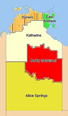
Katherine
The Katherine region is centred on the outback town of Katherine and forms one of the Territory's tourism regions.[2] The region is predominantly tropical savannah and semi-arid land. For local government purposes, it is further divided into the southern Victoria Daly and Roper Gulf regions.[3]
The Katherine region is represented in the Legislative Assembly by the members for Barkly, Katherine and Stuart.[4]
Barkly
The Barkly local government region is roughly coterminous with the Barkly Tableland and the "Tennant Creek and surrounds" tourist region.[2] The region is predominantly tropical savannah and semi-arid land. The Barkly region is represented in the Legislative Assembly by the member for Barkly.[4]
Alice Springs
Composed largely of desert, this area is divided into a northern, Central Desert, and a southern, MacDonnell Ranges, region.[3] For tourism purposes, the area is grouped into a single region centred on Alice Springs, with a smaller Uluru region excised in the south-west.[2] The region is often referred to informally as the "Red Centre", after the colour of the soil.
The Alice Springs region is represented in the Legislative Assembly by the members for Araluen, Braitling, Namatjira and Stuart.[4]
References
- "Australian Statistical Geography". Australian Bureau of Statistics.
- "Regional profiles". Tourism NT.
- "Council boundaries map" (PDF). Northern Territory Government.
- "Northern Territory of Australia: Boundaries of electoral divisions 2015" (PDF). Northern Territory Electoral Commission.
| Topics | ||
|---|---|---|
| Regions | ||
| Major settlements | ||
