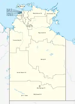
Local government areas of the Northern Territory
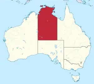
The Northern Territory is a federal Australian territory in the central and central northern regions of Australia. It is the third largest Australian federal division with an area of 1,348,094.3 square kilometres (520,502 sq mi) but the least populous with 245,929 inhabitants as at June 2019.[1] The Northern Territory is divided administratively into 17 Local government areas (LGAs) generally known as Councils who are responsible for providing local government services.[2]
Area types
As of 1 July 2008, there were two classifications of local government in the Northern Territory:
- Municipalities (predominantly inner-city suburban areas and smaller rural towns), of which there were five; and
- Shires or Regions (predominantly rural or outer suburban areas), of which there were eleven shire councils
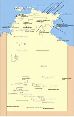
The Northern Territory was unusual as a comparatively large share of the territory's population lived in unincorporated areas. In 2006, prior to the reorganisation of local government areas in the territory, 92 percent of the land area (1,237,999 km2 (477,994 sq mi) out of 1,349,130 km2 (520,900 sq mi)) with 16 percent of the population (30,523 out of 192,898), was unincorporated.
Most of the unincorporated areas disappeared as a result of local government reform in 2008. The area remaining unincorporated is 19,790 km2 (7,640 sq mi), 1.47 percent of the total,[3][1] and contains 3.0 percent of the population in June 2019.[1]
By comparison, in the only other states or territories in Australia with unincorporated areas, only 0.02% of the population of New South Wales, 0.002% of Victoria's population and 0.6% of the population of South Australia, live in unincorporated areas.
Current local government areas
| Local government area | Council seat | Region | Type | Year est. | Land area[1] | Population | Notes | ||
|---|---|---|---|---|---|---|---|---|---|
| km² | sq mi | 2014[4] | 2019[4][1] | ||||||
| Alice Springs Town Council | Alice Springs | Central Australia | Municipality | 1 July 1971 | 328 | 127 | 27,486 | 26,390 | |
| Alyangula | Alyangula | Arnhem Land | Unincorporated area | 1960s | 2 | 1 | 986[5] | 873[6] | |
| Barkly Regional Council | Tennant Creek | Barkly Tableland | Region | 1 July 2008 | 322,713 | 124,600 | 7,663 | 7,369 | |
| Belyuen Community Government Council | Belyuen | Greater Darwin | Shire | 1 July 2008 | 41 | 16 | 188 | 175 | |
| Central Desert Regional Council | Alice Springs | Central Australia | Region | 1 July 2008 | 281,312 | 108,615 | 4,316 | 4,231 | |
| Coomalie Community Government Council | Batchelor | Greater Darwin | Shire | 7 December 1990 | 2,056 | 794 | 1,374 | 1,370 | |
| Darwin, City of | Darwin | Greater Darwin | City | 1959 (as a city) | 111 | 43 | 83,098 | 82,886 |
|
| Northern Territory Rates Act Area (East Arm) | Greater Darwin | Unincorporated area | 52 | 20 | |||||
| East Arnhem Regional Council | Nhulunbuy | Arnhem Land | Region | 1 July 2008 | 33,310 | 12,861 | 10,469 | 10,344 | |
| Katherine Town Council | Katherine | Katherine | Municipality | 3 March 1978 | 7,417 | 2,864 | 10,744 | 10,623 | |
| Litchfield Council | Freds Pass | Greater Darwin | Municipality | 6 September 1985 | 2,903 | 1,121 | 23,256 | 25,561 | |
| MacDonnell Regional Council | Alice Springs | Central Australia | Region | 1 July 2008 | 268,329 | 103,602 | 6,875 | 6,917 | |
| Nhulunbuy Corporation | Nhulunbuy | Arnhem Land | Unincorporated area | 7 | 3 | 4,072[7] | 3,240[8] | ||
| Palmerston, City of | Palmerston | Greater Darwin | City | 2000 (as a city) | 53 | 20 | 34,001 | 38,270 | |
| Roper Gulf Regional Council | Katherine | Katherine | Region | 1 July 2008 | 185,210 | 71,510 | 7,272 | 7,428 | |
| Tiwi Islands Regional Council | Darwin | Greater Darwin | Region | 1 July 2008 | 7,483 | 2,889 | 2,902 | 2,741 | |
| Unincorporated Top End Region (Finnis-Mary) | Greater Darwin | Unincorporated area | 19,263 | 7,437 | |||||
| Victoria Daly Regional Council | Katherine | Katherine | Region | 1 July 2008 | 153,287 | 59,184 | 3,269 | 3,155 | De-amalgamated in 2014 into Victoria Daly and West Daly Regional Councils |
| Wagait Shire Council | Wagait Beach | Greater Darwin | Shire | 1 July 2008 | 6 | 2 | 467 | 519 | Formerly the Cox Peninsula Community Government Council, established on 28 April 1995. |
| West Arnhem Regional Council | Jabiru | Arnhem Land | Region | 1 July 2008 | 49,675 | 19,180 | 7,157 | 6,881 | |
| West Daly Regional Council | Wadeye | Katherine | Region | 1 July 2014[9] | 14,070 | 5,432 | 3,587 | 3,693 | Part of Victoria Daly Regional Council from 2008 until 2014 de-amalgamation |
| Yulara | Yulara | Central Australia | Unincorporated area | 103 | 40 | 986[10] | 1099[11] | ||
Former local government areas
Prior to 1 July 2008, local government areas in the Northern Territory were classified as either :
- Community Government Councils of which 51 existed,
- Incorporated Associations (Commonwealth) of which three existed,
- Municipalities of which six existed and
- Special Purpose Towns of which there is only one example.
Towns
- Town of Jabiru (special purpose town)
- Town of Tennant Creek
Community Government Councils
- Alpurrurulam CGC
- Angurugu CGC
- Anmatjere CGC
- Arltarlpilta CGC
- Belyuen CGC (now Belyuen Shire)
- Binjari CGC
- Borroloola CGC
- Coomalie CGC (now Coomalie Shire)
- Cox Peninsula CGC (now Wagait Shire)
- Daguragu CGC
- Elliott District CGC
- Jilkminggan CGC
- Kunbarllanjnja CGC
- Lajamanu CGC
- Ltyentye Apurte CGC
- Marngarr CGC
- Mataranka CGC
- Nauiyu Nambiyu CGC
- Numbulwar Numburindi CGC
- Nyirranggulung Mardrulk Ngadberre Regional Council
- Pine Creek CGC
- Tapatjatjaka CGC
- Thamarrurr Regional Council
- Timber Creek CGC
- Tiwi Islands CGC (now Tiwi Islands Region)
- Walangeri Ngumpinku CGC
- Wallace Rockhole CGC
- Watiyawanu CGC
- Yuendumu CGC
- Yugul Mangi CGC
Incorporated Communities
- Aherrenge Community
- Ali Curung Community
- Amoonguna Community
- Aputula Community
- Areyonga Community
- Galiwin'ku Community
- Gapuwiyak Community
- Ikuntji Community
- Imanpa Community
- Kaltukatjara Community
- Maningrida Community
- Milingimbi Community
- Milyakburra Community
- Minjilang Community
- Mutitjulu Community
- Nganmarriyanga Community
- Ntaria Community (Hermannsburg)
- Nyirrpi Community
- Papunya Community
- Peppimenarti Community
- Ramingining Community
- Umbakumba Community
- Urapuntja Aboriginal Corporation
- Walungurru Community
- Warruwi Community
- Yuelamu Community
Unincorporated Area
- Unincorporated Area: A contiguous 92 percent of the area did not belong to any local government area. The LGAs were enclaves within unincorporated territory.
See also
References
- "3218.0 – Regional Population Growth, Australia, 2018-19: Population Estimates by Local Government Area , 2018 to 2019". Australian Bureau of Statistics. Australian Bureau of Statistics. 25 March 2020. Retrieved 23 August 2020. Estimated resident population, 30 June 2019.
- Northern Territory LGA History Archived 26 October 2004 at the Wayback Machine
- "Archived copy". Archived from the original on 11 July 2009. Retrieved 24 July 2009.CS1 maint: archived copy as title (link) and "Archived copy". Archived from the original on 11 July 2009. Retrieved 24 July 2009.CS1 maint: archived copy as title (link)
- "People: Population: ERP by LGA (ASGS 2019), 2001 to 2019". ABS.Stat. Australian Bureau of Statistics. Retrieved 24 September 2020.
- Australian Bureau of Statistics (31 October 2012). "Alyangula (SLA)". 2011 Census QuickStats. Retrieved 31 May 2016.

- Australian Bureau of Statistics (27 June 2017). "Alyangula (State Suburb)". 2016 Census QuickStats. Retrieved 11 April 2018.
- Australian Bureau of Statistics (27 June 2017). "Nhulunbuy (State Suburb)". 2016 Census QuickStats. Retrieved 11 April 2018.
- Australian Bureau of Statistics (27 June 2017). "Nhulunbuy (State Suburb)". 2016 Census QuickStats. Retrieved 11 April 2018.
- https://dhcd.nt.gov.au/__data/assets/pdf_file/0006/155922/West_Daly_Restructure_Order_2014.pdf
- Australian Bureau of Statistics (31 October 2012). "Yulara (State Suburb)". 2011 Census QuickStats. Retrieved 16 February 2014.
- Australian Bureau of Statistics (27 June 2017). "Yulara (State Suburb)". 2016 Census QuickStats. Retrieved 11 April 2018.
Sources
- "Shires of Australia". Statoids.
| Topics | ||
|---|---|---|
| Regions | ||
| Major settlements | ||