Richard B. Russell Airport
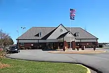
Richard B. Russell Airport[1] (IATA: RMG, ICAO: KRMG, FAA LID: RMG) is a county-owned public-use airport in Floyd County, Georgia, United States. The airport is located six nautical miles (11 km) north of the central business district of Rome, Georgia.[1] It is also known as Richard B. Russell Regional Airport.[2]
Richard B. Russell Airport | |||||||||||||||
|---|---|---|---|---|---|---|---|---|---|---|---|---|---|---|---|
 | |||||||||||||||
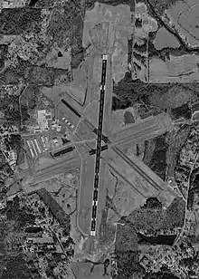
 USGS aerial image - 8 February 1999 | |||||||||||||||
| Summary | |||||||||||||||
| Airport type | Public | ||||||||||||||
| Owner | Floyd County | ||||||||||||||
| Serves | Rome, Georgia | ||||||||||||||
| Elevation AMSL | 644 ft / 196 m | ||||||||||||||
| Coordinates | 34°21′03″N 085°09′31″W | ||||||||||||||
| Website | https://russellregionalairport.com/ | ||||||||||||||
| Runways | |||||||||||||||
| |||||||||||||||
| Statistics (2007) | |||||||||||||||
| |||||||||||||||
This airport is included in the FAA's National Plan of Integrated Airport Systems (2009-2013), which categorizes it as a general aviation facility.[3]
The Rome Composite Squadron of the Civil Air Patrol is located at the airport. Stationed at the squadron are a Maule MT-7-235 tow plane and three Blanik gliders.[4]
On the first Saturday of each month, the Experimental Aircraft Association hosts a fly-in breakfast at the EAA campgrounds located off the Old Dalton Road.[2]
History
Floyd County purchased 670 acres (271 ha) of land for the airport in 1942. The county turned the land over to the U.S. Navy which built three asphalt runways for a Naval Auxiliary Air Station. It was deeded back to the county in 1945, after the Navy discontinued its use of the site.[5] The airport was then named for Richard B. Russell, Jr.,[5] who represented Georgia in the U.S. Senate from 1933 until his death in 1971.
Eastern Airlines served the airport with scheduled passenger service until the late 1960s. Eastern operated Convair 440 propliners with service to Atlanta, Nashville and St. Louis.[6] [7]
Facilities and aircraft

The airport covers an area of 985 acres (399 ha) at an elevation of 644 feet (196 m) above mean sea level. It has two asphalt paved runways: 1/19 measures 6,006 by 143 feet (1,831 x 44 m) and 7/25 is 4,497 by 100 feet (1,371 x 30 m).[1] A former third runway which was designated 14/32 is closed.
For the 12-month period ending August 31, 2007, the airport had 36,703 aircraft operations, an average of 100 per day: 98% general aviation and 2% military. At that time there were 775 aircraft based at this airport: 88% military, 9% single-engine, 1% multi-engine, 1% ultralight, <1% glider, <1% jet and <1% helicopter.[1]
References
- FAA Airport Form 5010 for RMG PDF. Federal Aviation Administration. Effective 27 August 2009.
- "Richard B. Russell Airport". Floyd County, Georgia. Archived from the original on May 4, 2009. Retrieved 27 October 2009.
- FAA National Plan of Integrated Airport Systems: 2009-2013 Archived August 6, 2011, at the Wayback Machine. Federal Aviation Administration. Published 1 October 2008.
- "Rome Composite Squadron". Civil Air Patrol. Archived from the original on 5 September 2009. Retrieved 27 October 2009.
- "History of Russell Airport". Floyd County, Georgia. Archived from the original on July 23, 2008. Retrieved 27 October 2009.
- http://www.60sairlineantiques.net/timetables/Eastern-1965
- http://www.timetableimages.com, June 17, 1967 Eastern Airlines system timetable
External links
| Wikimedia Commons has media related to Richard B. Russell Airport. |
- "Richard B. Russell Regional Airport: 2008 Annual Report" (PDF). (266 KB)
- Richard B. Russell Airport (RMG) at Georgia DOT website
- FAA Airport Diagram for Richard B. Russell (RMG) (PDF), effective January 28, 2021
- FAA Terminal Procedures for Richard B. Russell (RMG), effective January 28, 2021
- Resources for this airport:
- FAA airport information for RMG
- AirNav airport information for KRMG
- ASN accident history for RMG
- FlightAware airport information and live flight tracker
- NOAA/NWS weather observations: current, past three days
- SkyVector aeronautical chart, Terminal Procedures
