Riggs Peak
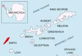
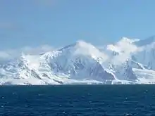
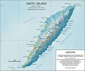
Riggs Peak (Bulgarian: връх Ригс, romanized: vrah Riggs, IPA: [ˈvrɤx ˈriks]) is a peak rising to 1690 m in Imeon Range on Smith Island, South Shetland Islands. Situated 2.38 km southwest of Neofit Peak, 5.4 km southwest of the summit Mount Foster, and 8.6 km northeast of Cape James. Overlooking Letnitsa Glacier to the south, and Gramada Glacier to the east. Bulgarian early mapping in 2009. Named after the American missionary and linguist Elias Riggs (1810–1901) who contributed greatly to the Bulgarian National Revival, and organized the first translation (by Neofit Rilski), printing and dissemination of the Bible in modern Bulgarian language.
Maps
- Chart of South Shetland including Coronation Island, &c. from the exploration of the sloop Dove in the years 1821 and 1822 by George Powell Commander of the same. Scale ca. 1:200000. London: Laurie, 1822.
- L.L. Ivanov. Antarctica: Livingston Island and Greenwich, Robert, Snow and Smith Islands. Scale 1:120000 topographic map. Troyan: Manfred Wörner Foundation, 2010. ISBN 978-954-92032-9-5 (First edition 2009. ISBN 978-954-92032-6-4)
- South Shetland Islands: Smith and Low Islands. Scale 1:150000 topographic map No. 13677. British Antarctic Survey, 2009.
- Antarctic Digital Database (ADD). Scale 1:250000 topographic map of Antarctica. Scientific Committee on Antarctic Research (SCAR). Since 1993, regularly upgraded and updated.
- L.L. Ivanov. Antarctica: Livingston Island and Smith Island. Scale 1:100000 topographic map. Manfred Wörner Foundation, 2017. ISBN 978-619-90008-3-0
References
- Riggs Peak. SCAR Composite Antarctic Gazetteer
- Bulgarian Antarctic Gazetteer. Antarctic Place-names Commission. (details in Bulgarian, basic data in English)
External links
- Riggs Peak. Copernix satellite image
This article includes information from the Antarctic Place-names Commission of Bulgaria which is used with permission.
