Smith Island (South Shetland Islands)
Smith Island is 20 miles (32 km) long and 5 miles (8.0 kilometres) wide, lying 45 miles (72 km) west of Deception Island in the South Shetland Islands of the British Antarctic Territory. Surface area 148 square kilometres (57 sq mi).[1]
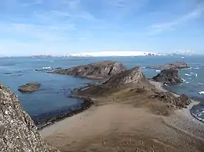 Smith Island on the horizon on the right, seen from Lucifer Crags on Byers Peninsula, Livingston Island, with Devils Point and Hell Gates in the foreground and Morton Strait and Snow Island in the background | |
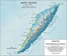 Topographic map of Smith Island | |
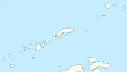 Smith Island Location of in the South Shetland Islands  Smith Island Location in Antarctica | |
| Geography | |
|---|---|
| Location | Antarctica |
| Coordinates | 63°00′S 62°30′W |
| Archipelago | South Shetland Islands |
| Area | 148 km2 (57 sq mi) |
| Length | 20 mi (30 km) |
| Width | 5 mi (8 km) |
| Highest elevation | 2,105 m (6906 ft) |
| Highest point | Mount Foster |
| Administration | |
| Administered under the Antarctic Treaty System | |
| Demographics | |
| Population | 0 |
The discovery of the South Shetland Islands was first reported in 1819 by Capt. William Smith, for whom the island is named. This island was known to both American and British sealers as early as 1820, and the name Smith has been well established in international usage for over 100 years, although in Russian literature it is often referred to as Borodino Island, sometimes marked as Borodino (Smith) Island.
The island hosts no research stations or camps, and is seldom visited by scientists or mountaineers. Its interior is entirely occupied by Imeon Range rising to 2,105 m (6,906 ft) (Mount Foster). The first detailed topographic mapping of the island was made by the Antarctic Place-names Commission and the Military Geographic Service of the Bulgarian Army and published in 2009[1] in both English and Bulgarian.
Maps
- Chart of South Shetland including Coronation Island, &c. from the exploration of the sloop Dove in the years 1821 and 1822 by George Powell Commander of the same. Scale ca. 1:200000. London: Laurie, 1822.
- L.L. Ivanov. Antarctica: Livingston Island and Greenwich, Robert, Snow and Smith Islands. Scale 1:120000 topographic map. Troyan: Manfred Wörner Foundation, 2010. ISBN 978-954-92032-9-5 (First edition 2009. ISBN 978-954-92032-6-4)
- South Shetland Islands: Smith and Low Islands. Scale 1:150000 topographic map No. 13677. British Antarctic Survey, 2009.
- Antarctic Digital Database (ADD). Scale 1:250000 topographic map of Antarctica. Scientific Committee on Antarctic Research (SCAR). Since 1993, regularly upgraded and updated.
- L.L. Ivanov. Antarctica: Livingston Island and Smith Island. Scale 1:100000 topographic map. Manfred Wörner Foundation, 2017. ISBN 978-619-90008-3-0
See also
- Composite Antarctic Gazetteer
- Imeon Range
- List of Antarctic islands south of 60° S
- SCAR
- South Shetland Islands
- Territorial claims in Antarctica
References
- L.L. Ivanov. Antarctica: Livingston Island and Greenwich, Robert, Snow and Smith Islands. Scale 1:120000 topographic map. Troyan: Manfred Wörner Foundation, 2010. ISBN 978-954-92032-9-5 (First edition 2009. ISBN 978-954-92032-6-4)
External links
![]() This article incorporates public domain material from the United States Geological Survey document: "Smith Island (South Shetland Islands)". (content from the Geographic Names Information System)
This article incorporates public domain material from the United States Geological Survey document: "Smith Island (South Shetland Islands)". (content from the Geographic Names Information System)
| General |
| .svg.png.webp) |
|---|---|---|
| Regions | ||
| Waterways | ||
| Famous explorers | ||