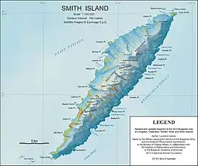
Imeon Range
Imeon Range (Bulgarian: Хребет Имеон, ‘Hrebet Imeon’ \'hre-bet i-me-'on\) (62°58′30″S 62°30′20″W) is a mountain range occupying the interior of Smith Island in the South Shetland Islands, Antarctica. Extending 30 km in southwest-northeast direction between Cape James and Cape Smith, and 6.8 km wide. Its summit Mount Foster – summit of the South Shetlands archipelago too – is a double peak, the higher south height of which (2105 m) was first climbed on January 30, 1996 by a New Zealand team led by Greg Landreth. Other prominent peaks include Evlogi Peak (2090 m), Antim Peak (2080 m), Mount Pisgah (1860 m), Slaveykov Peak (1760 m), Neofit Peak (1750 m), Drinov Peak (1630 m), Riggs Peak (1690 m) and Mount Christi (1280 m).
| Imeon Range | |
|---|---|
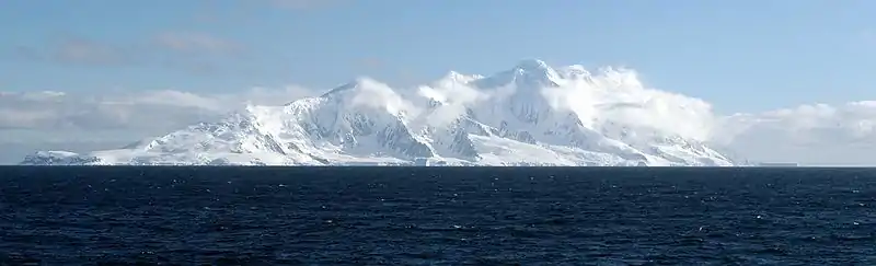
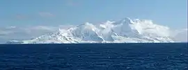 Southern Imeon Range from Osmar Strait | |
| Highest point | |
| Peak | Mount Foster |
| Elevation | 2,105 m (6,906 ft) |
| Dimensions | |
| Length | 30 km (19 mi) |
| Width | 6.8 km (4.2 mi) |
| Geography | |
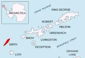 Location of Smith Island in the South Shetland Islands
| |
| Country | Antarctica |
| Region | South Shetland Islands |
| Range coordinates | 62°58′30″S 62°30′20″W |
The range is named after Mount Imeon (present day Pamir, Hindu Kush, and Tian Shan), whose highlands and valleys around upper Oxus River (Amu Darya) were described as the ancient homeland of Bulgars by the seventh century Armenian geography index ‘Ashharatsuyts’ by Anania Shirakatsi.
History
The first ascent of the summit Mount Foster was made by Greg Landreth and team on 29 January 1996.[1] Antim Peak was first ascended by the French mountaineers Mathieu Cortial, Lionel Daudet and Patrick Wagnon on 12 January 2010. Their route called Le vol du sérac (Flight of the Serac) followed the western spur of the peak.[2][3]
Maps
- Chart of South Shetland including Coronation Island, &c. from the exploration of the sloop Dove in the years 1821 and 1822 by George Powell Commander of the same. Scale ca. 1:200000. London: Laurie, 1822.
- L.L. Ivanov. Antarctica: Livingston Island and Greenwich, Robert, Snow and Smith Islands. Scale 1:120000 topographic map. Troyan: Manfred Wörner Foundation, 2010. ISBN 978-954-92032-9-5 (First edition 2009. ISBN 978-954-92032-6-4)
- South Shetland Islands: Smith and Low Islands. Scale 1:150000 topographic map No. 13677. British Antarctic Survey, 2009.
- Antarctic Digital Database (ADD). Scale 1:250000 topographic map of Antarctica. Scientific Committee on Antarctic Research (SCAR). Since 1993, regularly upgraded and updated.
- L.L. Ivanov. Antarctica: Livingston Island and Smith Island. Scale 1:100000 topographic map. Manfred Wörner Foundation, 2017. ISBN 978-619-90008-3-0
Notes
- News from Antarctica: Mount Foster’s first ascent. Archived 2001-01-16 at the Wayback Machine
- No Man’s Land Project 2010. (Ascent)
- D. Gildea. 2009–10 Antarctic Peninsula summary. The American Alpine Journal 2010. pp. 193–198.
External links
- J. Stewart. Antarctica: An Encyclopedia. Jefferson, N.C. and London: McFarland, 2011. 1771 pp. ISBN 978-0-7864-3590-6
- Imeon Range. SCAR Composite Gazetteer of Antarctica.
- Bulgarian Antarctic Gazetteer. Antarctic Place-names Commission. (details in Bulgarian, basic data in English)
- Smith Island Expedition 2007/08
- Imeon Range. Copernix satellite image