Rivière-aux-Outardes, Quebec
Rivière-aux-Outardes is an unorganized territory in the Côte-Nord region of Quebec, Canada. It makes up almost 95% of the Manicouagan Regional County Municipality.
Rivière-aux-Outardes | |
|---|---|
 | |
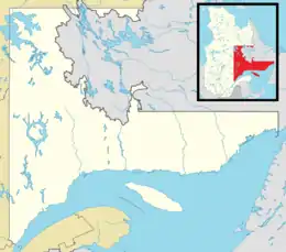 Rivière-aux-Outardes Location in Côte-Nord region of Quebec | |
| Coordinates: 50°15′N 69°00′W[1] | |
| Country | |
| Province | |
| Region | Côte-Nord |
| RCM | Manicouagan |
| Constituted | January 1, 1986 |
| Government | |
| • Federal riding | Manicouagan |
| • Prov. riding | René-Lévesque |
| Area | |
| • Total | 37,103.60 km2 (14,325.78 sq mi) |
| • Land | 33,726.44 km2 (13,021.85 sq mi) |
| Population (2011)[3] | |
| • Total | 86 |
| • Density | 0.0/km2 (0/sq mi) |
| • Pop 2006-2011 | |
| • Dwellings | 57 |
| Time zone | UTC−5 (EST) |
| • Summer (DST) | UTC−4 (EDT) |
| Area code(s) | 418 and 581 |
| Highways | |
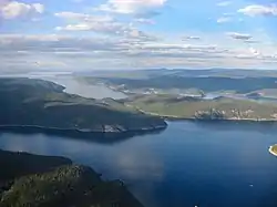
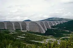
The eponymous Outardes River is nearly 400 kilometres (250 mi) long, and flows through the territory in a north-south direction before draining into Outardes Bay at Ragueneau. The other major river in the territory is the Manicouagan River that flows parallel and east of the Outardes River. Both these rivers are developed with large-scale hydroelectric installations, part of the Manic-Outardes Project.
The Manicouagan Reservoir, a circular lake that covers the Manicouagan crater, is almost entirely located within the territory.
Quebec Route 389, running for a large part between the Outardes and Manicouagan Rivers, provides access to the territory and the hydroelectric installations along these rivers. It is an isolated highway with few roadside services that are great distances apart.
Demographics
Population trend:[4]
- Population in 2011: 86 (2006 to 2011 population change: -35.8%)
- Population in 2006: 134
- Population in 2001: 48
- Population in 1996: 59
- Population in 1991: 32
Private dwellings occupied by usual residents: 48 (total dwellings: 57)
See also
References
- Reference number 149764 of the Commission de toponymie du Québec (in French)
- "Rivière-aux-Outardes". Répertoire des municipalités (in French). Ministère des Affaires municipales, des Régions et de l'Occupation du territoire. Retrieved 2012-05-11.
- "Rivière-aux-Outardes census profile". 2011 Census of Population. Statistics Canada. Retrieved 2012-05-11.
- Statistics Canada: 1996, 2001, 2006, 2011 census
External links
 Media related to Rivière-aux-Outardes, Quebec at Wikimedia Commons
Places adjacent to Rivière-aux-Outardes, Quebec | ||||||||||
|---|---|---|---|---|---|---|---|---|---|---|
| ||||||||||
| Cities & Towns | |
|---|---|
| Municipalities | |
| Parishes | |
| Villages | |
| Unorganized Territories | |
| Native reserves (Unassociated with RCM) | |
| |