Sept-Rivières Regional County Municipality
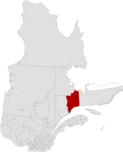
Sept-Rivières (French for "Seven-Rivers") is a regional county municipality of Quebec, Canada, in the Côte-Nord region. Its county seat is Sept-Îles.
Sept-Rivières | |
|---|---|
 | |
| Coordinates: 50°08′N 66°37′W[1] | |
| Country | |
| Province | |
| Region | Côte-Nord |
| Effective | March 18, 1981 |
| County seat | Sept-Îles |
| Government | |
| • Type | Prefecture |
| • Prefect | Serge Lévesque |
| Area | |
| • Total | 32,571.60 km2 (12,575.97 sq mi) |
| • Land | 30,469.17 km2 (11,764.21 sq mi) |
| Population | |
| • Total | 35,240 |
| • Density | 1.2/km2 (3/sq mi) |
| • Pop 2006-2011 | |
| • Dwellings | 16,065 |
| Time zone | UTC−5 (EST) |
| • Summer (DST) | UTC−4 (EDT) |
| Area code(s) | 418 and 581 |
| Website | www |
The census groups Sept-Rivières RCM with neighbouring Caniapiscau Regional County Municipality RCM into the single census division of Sept-Rivières—Caniapiscau. In the Canada 2011 Census, the combined population was 39,500. The population of Sept-Rivières RCM itself was 35,240,[4] of whom the vast majority live in the city of Sept-Îles.
Geography
Sept-Rivières is located in the central part of Côte-Nord. It is bordered by the regional county municipalities of Manicouagan, Caniapiscau, and Minganie, as well as by the southwest corner of Labrador and by the Gulf of Saint Lawrence. It is mostly covered by the Laurentian mountains. It is a very sparsely populated and undeveloped region with its population highly concentrated along the coast, mostly at Sept-Îles (about three-fourths of the population).
It allegedly takes its name from seven major rivers that join the Saint Lawrence within the territory: Moisie, Sainte-Marguerite, Trinité, Pentecôte, aux Rochers, Pigou and Manitou. But neither the Trinité River nor the Manitou River reaches the Saint Lawrence within the limits of the regional county municipality, and many other rivers could be amongst those "seven rivers".
Subdivisions
There are four subdivisions and two native reserves within the RCM:[2]
|
|
|
Transportation
River basins
There are a number of large rivers that flow in a generally north-south direction through Sept-Rivières to enter the Gulf. Near the coast the river basins tend to narrow in towards the river mouth, and between their mouths are areas that drain into the Gulf through smaller streams. From west to east, the larger river basins, which may cover parts of neighboring regions, are:[6]
| River | Basin size | Mouth coordinates | Map link | |
|---|---|---|---|---|
| km2 | sq. mile | |||
| Pentecôte | 1,986 | 767 | 49.7800000°N 67.1644444°W | EHOZH |
| Riverin | 221 | 85 | 49.7855556°N 67.1563889°W | EHWEN |
| Aux Rochers | 4,161 | 1,607 | 50.0194444°N 66.8686111°W | EHWSX |
| Dominique | 263 | 102 | 50.0263889°N 66.8680556°W | EGEDF |
| Sainte-Marguerite | 6,213 | 2,399 | 50.1427778°N 66.5966667°W | EJGWT |
| Rapides | 573 | 221 | 50.2686111°N 66.4572222°W | EHURW |
| Moisie | 19,273 | 7,441 | 50.2000000°N 66.067500°W | EHHGN |
| Matamec | 679 | 262 | 50.2836111°N 65.9666667°W | EHEPE |
| Loups Marins | 186 | 72 | 50.259167°N 65.744444°W | EHBME |
| Pigou | 169 | 65 | 50.2702778°N 65.6272222°W | EHQOC |
References
- Reference number 141179 of the Commission de toponymie du Québec (in French)
- Geographic code 971 in the official Répertoire des municipalités (in French)
- "(Code 2497) Census Profile". 2011 census. Statistics Canada. 2012.
- Derived indirectly from Sept-Rivières—Caniapiscau census division Hierarchy data, by summing up data for Lac-Walker, Maliotenam, Port-Cartier, Rivière-Nipissis, Sept-Îles and Uashat census subdivisions.
- Official Transport Quebec Road Map
- Portrait préliminaire de la zone de gestion intégrée de l'eau par bassin versant Duplessis (PDF) (in French), OBV Duplessis, April 2015, p. 20, retrieved 2019-09-29
Adjacent Counties & Equivalent Territories | |
|---|---|
| Administrative units |
| ||||
|---|---|---|---|---|---|
| Protected areas |
| ||||
| Major river basins | |||||
| Significant lakes | |||||
| Transport infrastructure | |||||
| |||||
| Regional county municipalities and equivalent territories | |
|---|---|
| Municipalities | |