Rock Hall, Maryland
Rock Hall, "The Pearl of the Chesapeake",[1] is a waterfront town located directly on the National Chesapeake Scenic Byway in Kent County, Maryland, United States. It is located less than two hours away from large metropolitan areas such as Philadelphia, Baltimore and Washington, D.C. The population was 1,310 at the 2010 census.
Rock Hall, Maryland | |
|---|---|
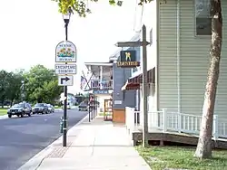 Main St. Rock Hall | |
| Nickname(s): Rock City | |
| Motto(s): "Pearl of the Chesapeake"[1] | |
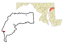 Location of Rock Hall, Maryland | |
| Coordinates: 39°8′12″N 76°14′31″W | |
| Country | |
| State | |
| County | |
| Founded | 1707 |
| Incorporated | 1908[2] |
| Government | |
| • Type | Mayor-Council-Manager |
| • Mayor | Hon. Dawn Jacobs |
| Area | |
| • Total | 1.55 sq mi (4.02 km2) |
| • Land | 1.34 sq mi (3.47 km2) |
| • Water | 0.21 sq mi (0.55 km2) |
| Elevation | 10 ft (3 m) |
| Population | |
| • Total | 1,310 |
| • Estimate (2019)[5] | 1,274 |
| • Density | 952.17/sq mi (367.53/km2) |
| Time zone | UTC-5 (Eastern (EST)) |
| • Summer (DST) | UTC-4 (EDT) |
| ZIP code | 21661 |
| Area code(s) | 410 |
| FIPS code | 24-67400 |
| GNIS feature ID | 0586872 |
| Website | Town of Rock Hall, Maryland |
History
Originally called Rock Hall Crossroads, the city is now a quaint fishing, sailing and recreational boating town situated picturesquely on the upper Eastern Shore of the Chesapeake Bay. It is the center of Kent County's maritime industries and is also a popular destination for art, music, culture and wildlife enthusiasts. Even before the establishment in 1707,[1] the Chesapeake Bay and its tributaries have shaped the economic and cultural development of the Town. In the early years, the Bay served as a commercial link to other populated areas on the western shore, such as Baltimore, Annapolis and Virginia, as well as northern areas such as Philadelphia and New York.
The city was named for a mansion made of white sandstone,[6] and was incorporated in 1908.[7]
Rock Hall served as a shipping point for tobacco, seafood and other agricultural products, as well as a passenger transport connection for travelers during the Colonial era. Famous Americans, such as George Washington, James Madison and others have passed through Rock Hall numerous times traversing between Virginia and their northbound destinations. Later, fishing and seafood processing became the Town's largest industry, providing an economic base for commerce and town community life. Maryland blue crabs, oysters, striped bass, and more, although less plentiful today, have comprised the bountiful seasonal harvests of the Upper Chesapeake Bay.
The town just missed out on receiving a railroad connection in 1872, when the Kent County Railroad set out to build from Massey via Chestertown and connect with a ferry to Baltimore for both passengers and freight. The company went bankrupt in 1877, having only built a stub from Chestertown to a place called Belair or Parsons and abandoning the rest unfinished.[8][9]
Rock Hall Harbor continues to be a working harbor with an active fleet of commercial watermen who leave the dock each day. Rock Hall has three museums including a Waterman's museum. This is presently located in the Town Hall with many artifacts to preserve the heritage of the iconic way of life associated with the Chesapeake Bay waterman. In recent years, recreational interests, shopping and tourism have emerged as a strong economic transformation with Rock Hall serving as one of the larger charter boat fishing and sailing centers on the Eastern Shore.
Hinchingham and Trumpington are listed on the National Register of Historic Places.[10]
Geography
According to the United States Census Bureau, the town has a total area of 1.55 square miles (4.01 km2), of which 1.34 square miles (3.47 km2) is land and 0.21 square miles (0.54 km2) is water.[11]


Demographics
| Historical population | |||
|---|---|---|---|
| Census | Pop. | %± | |
| 1880 | 221 | — | |
| 1910 | 781 | — | |
| 1930 | 405 | — | |
| 1940 | 781 | 92.8% | |
| 1950 | 786 | 0.6% | |
| 1960 | 1,073 | 36.5% | |
| 1970 | 1,125 | 4.8% | |
| 1980 | 1,511 | 34.3% | |
| 1990 | 1,584 | 4.8% | |
| 2000 | 1,396 | −11.9% | |
| 2010 | 1,310 | −6.2% | |
| 2019 (est.) | 1,274 | [5] | −2.7% |
| U.S. Decennial Census[12] | |||
2010 census
As of the census[4] of 2010, there were 1,310 people, 630 households, and 374 families residing in the town. The population density was 977.6 inhabitants per square mile (377.5/km2). There were 930 housing units at an average density of 694.0 per square mile (268.0/km2). The racial makeup of the town was 92.0% White, 5.8% African American, 0.2% Asian, 0.1% from other races, and 1.9% from two or more races. Hispanic or Latino of any race were 1.5% of the population.
There were 630 households, of which 19.2% had children under the age of 18 living with them, 43.5% were married couples living together, 11.4% had a female householder with no husband present, 4.4% had a male householder with no wife present, and 40.6% were non-families. 35.9% of all households were made up of individuals, and 19.7% had someone living alone who was 65 years of age or older. The average household size was 2.05 and the average family size was 2.57.
The median age in the town was 54.3 years. 15.2% of residents were under the age of 18; 5.3% were between the ages of 18 and 24; 16.4% were from 25 to 44; 33% were from 45 to 64; and 30% were 65 years of age or older. The gender makeup of the town was 47.2% male and 52.8% female.
2000 census
As of the census[13] of 2000, there were 1,396 people, 654 households, and 408 families residing in the town. The population density was 1,050.3 people per square mile (405.3/km2). There were 834 housing units at an average density of 627.5 per square mile (242.1/km2). The racial makeup of the town was 92.91% White, 5.52% African American, 0.07% Native American, 0.14% Asian, 0.07% Pacific Islander, 0.14% from other races, and 1.15% from two or more races. Hispanic or Latino of any race were 0.86% of the population.
There were 654 households, out of which 23.1% had children under the age of 18 living with them, 47.6% were married couples living together, 11.9% had a female householder with no husband present, and 37.5% were non-families. 32.4% of all households were made up of individuals, and 19.7% had someone living alone who was 65 years of age or older. The average household size was 2.13 and the average family size was 2.67.
In the town, the population was spread out, with 19.8% under the age of 18, 5.5% from 18 to 24, 21.3% from 25 to 44, 29.5% from 45 to 64, and 23.9% who were 65 years of age or older. The median age was 47 years. For every 100 females, there were 87.1 males. For every 100 females age 18 and over, there were 84.2 males.
The median income for a household in the town was $32,833, and the median income for a family was $38,672. Males had a median income of $29,375 versus $21,429 for females. The per capita income for the town was $20,521. About 10.5% of families and 13.2% of the population were below the poverty line, including 22.4% of those under age 18 and 10.0% of those age 65 or over.
Economy
A variety of retail shops are located on Main Street. Oyster collection, crabbing and fishing contribute to the economy as do charter boats for fishing trips. Tourism is also a source of income, particularly over the summer months and on special events weekends such as the Pirates and Wenches Weekend. It is also a center in the area for July 4 celebrations.


Government
The town has a Weak Mayor-Council-Manager form of government.[14] As of 2016, the mayor is Dawn Jacobs.[15] [16][17]
Notable person
- Lambert Wickes (1735–1777)
References
- "Town of Rock Hall, Maryland". Town of Rock Hall, Maryland. Retrieved August 24, 2012.
- "Rock Hall". Maryland Manual. Retrieved 27 June 2017.
- "2019 U.S. Gazetteer Files". United States Census Bureau. Retrieved July 25, 2020.
- "U.S. Census website". United States Census Bureau. Retrieved 2013-01-25.
- "Population and Housing Unit Estimates". United States Census Bureau. May 24, 2020. Retrieved May 27, 2020.
- "Profile for Rock Hall Maryland, MD". ePodunk. Retrieved August 25, 2012.
- "Rock Hall, Maryland". Town City-Data.com. Retrieved August 24, 2012.
- Railway World, Volume 21 1877 p. 613
- Walker, M: SPV's Comprehensive Railroad Atlas, Northeast 1993 p. 12
- "National Register Information System". National Register of Historic Places. National Park Service. July 9, 2010.
- "US Gazetteer files 2010". United States Census Bureau. Archived from the original on 2012-01-25. Retrieved 2013-01-25.
- "Census of Population and Housing". Census.gov. Retrieved June 4, 2015.
- "U.S. Census website". United States Census Bureau. Retrieved 2008-01-31.
- Divilio, Daniel (December 4, 2014). "Charter change approved as mayor continues lawsuit". The Star Democrat. Easton, Maryland: TownNews.com. Retrieved 27 March 2016.
- "KENT COUNTY, MARYLAND: Rock Hall". Maryland State Archives. Retrieved 27 March 2016.
- "Brian Jones: Mayor". Town of Rock Hall, Maryland.
- Mitchell, Dorian (May 7, 2015). "New mayor elected in Rock Hall". The Star Democrat. Easton, Maryland: TownNews.com. Retrieved 27 March 2016.
External links
- Town website
- Map and directory of Rock Hall, from 1876 Atlas by Lake, Griffing and Stevenson
Municipalities and communities of Kent County, Maryland, United States | ||
|---|---|---|
| Towns |  | |
| CDPs | ||
| Unincorporated communities | ||
| Footnotes | ‡This populated place also has portions in an adjacent county or counties | |
| ||
| Authority control |
|---|