Rolleston, Queensland
Rolleston is a small town and locality in the Central Highlands Region, Queensland, Australia.[1][2]
| Rolleston Queensland | |||||||||||||||
|---|---|---|---|---|---|---|---|---|---|---|---|---|---|---|---|
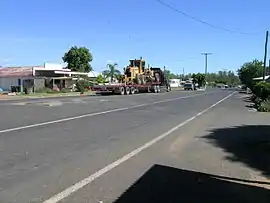 The main street of Rolleston | |||||||||||||||
 Rolleston | |||||||||||||||
| Coordinates | 24°28′S 148°36′E | ||||||||||||||
| Population | 309 (2016 census) | ||||||||||||||
| Postcode(s) | 4702 | ||||||||||||||
| Location |
| ||||||||||||||
| LGA(s) | Central Highlands Region | ||||||||||||||
| State electorate(s) | Gregory | ||||||||||||||
| Federal Division(s) | Flynn | ||||||||||||||
| |||||||||||||||
| |||||||||||||||
History
Rolleston was built on Kanolu land.
Wadja (also known as Wadjigu, Wadia, Wadjainngo, Mandalgu, and Wadjigun) is an Australian Aboriginal language in Central Queensland. The language region includes the local government areas of the Aboriginal Shire of Woorabinda and Central Highlands Region, including the Blackdown Tablelands. the Comet River, and the Expedition Range, and the towns of Woorabinda, Springsure and Rolleston.[3]
The town is named after Christopher Rolleston, a pastoralist who was involved in leasing a number of pastoral runs in the area in the 1860s.[1][2]
At the 2006 census, Rolleston and the surrounding area had a population of 123.
In the 2011 census, Rolleston had a population of 129 people.[4]
Geography
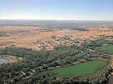
It is located on the Comet River, 335 kilometres (208 mi) west of Gladstone, 263 kilometres (163 mi) north of Roma and 694 kilometres (431 mi) northwest of Brisbane. Springsure, the nearest town lies 71 kilometres (44 mi) to the north-west. Rolleston lies on the junction of the Carnarvon, Gregory and Dawson highways.
Bushrangers
Queensland's last legendary cattle thieves and bushrangers, the notorious Patrick and James Kenniff, frequently lived within the nearby now-Carnarvon National Park, at Lethbridge Pocket. It was here in March 1903 they murdered Constable George Doyle and cattle station manager Albert Dahlke.
Mining
There is a large coal mine 13 kilometres (8.1 mi) west called the Rolleston coal mine. Mining began in October 2005 and is expected to last more than 20 years.[5]
Facilities
The Central Highlands Regional Council operates a public library on Planet Street.[6]
Education
Rolleston State School opened on 9 October 1871.[7]
Gallery
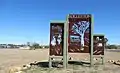 Entrance sign for Rolleston, Queensland.
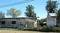 Rolleston State School, Queensland, Australia. Established 9 October 1871.
See also
References
- "Rolleson – town (entry 28948)". Queensland Place Names. Queensland Government. Retrieved 10 March 2017.
- "Rolleson – locality (entry 46975)". Queensland Place Names. Queensland Government. Retrieved 10 March 2017.
-
 This Wikipedia article incorporates CC-BY-4.0 licensed text from: "Wadja". Queensland Aboriginal and Torres Strait Islander languages map. State Library of Queensland. Retrieved 5 February 2020.
- Australian Bureau of Statistics (31 October 2012). "Rolleston (SSC)". 2011 Census QuickStats. Retrieved 10 March 2017.

- Department of Infrastructure and Planning. "Rolleston Coal Project". Government of Queensland. Archived from the original on 29 June 2009. Retrieved 30 June 2009.
- "Rolleston Library". Public Libraries Connect. State Library of Queensland. 31 March 2017. Archived from the original on 29 January 2018. Retrieved 29 January 2018.
- "Opening and closing dates of Queensland Schools". Queensland Government. Retrieved 18 April 2019.